
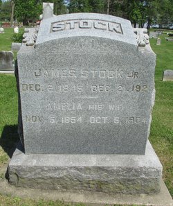
James A. Stock Jr.
| Birth | : | 2 Dec 1845 |
| Death | : | 21 Dec 1921 Jasper County, Iowa, USA |
| Burial | : | Coral Cemetery, Coral, Montcalm County, USA |
| Coordinate | : | 43.3671989, -85.4060974 |
frequently asked questions (FAQ):
-
Where is James A. Stock Jr.'s memorial?
James A. Stock Jr.'s memorial is located at: Coral Cemetery, Coral, Montcalm County, USA.
-
When did James A. Stock Jr. death?
James A. Stock Jr. death on 21 Dec 1921 in Jasper County, Iowa, USA
-
Where are the coordinates of the James A. Stock Jr.'s memorial?
Latitude: 43.3671989
Longitude: -85.4060974
Family Members:
Parent
Spouse

Siblings

Children
Flowers:


Nearby Cemetories:
1. Coral Cemetery
Coral, Montcalm County, USA
Coordinate: 43.3671989, -85.4060974
2. Coady Cemetery
Maple Valley Township, Montcalm County, USA
Coordinate: 43.3540520, -85.3825890
3. Maple Valley Cemetery
Maple Valley Township, Montcalm County, USA
Coordinate: 43.3358002, -85.3724976
4. West Pine Cemetery
Coral, Montcalm County, USA
Coordinate: 43.3669014, -85.3227997
5. Trufant Cemetery
Maple Valley Township, Montcalm County, USA
Coordinate: 43.3083000, -85.3653030
6. Reynolds Township Cemetery
Howard City, Montcalm County, USA
Coordinate: 43.4101300, -85.4767100
7. Amble Cemetery
Amble, Montcalm County, USA
Coordinate: 43.4352989, -85.4024963
8. Pierson Township Cemetery
Pierson, Montcalm County, USA
Coordinate: 43.3381004, -85.5006027
9. Dickerson-Whitsell Cemetery
Lakeview, Montcalm County, USA
Coordinate: 43.4533005, -85.3227997
10. Boyd Cemetery
Morley, Mecosta County, USA
Coordinate: 43.4796982, -85.3818970
11. Saint Mary's Cemetery
Sand Lake, Kent County, USA
Coordinate: 43.2717018, -85.4969025
12. Sand Lake Cemetery
Sand Lake, Kent County, USA
Coordinate: 43.2861480, -85.5313380
13. Saint Apollonia Cemetery
Morley, Mecosta County, USA
Coordinate: 43.4907990, -85.4278030
14. Lakeview Cemetery
Lakeview, Montcalm County, USA
Coordinate: 43.4467010, -85.2739029
15. Bouton Family Farm Burial Site
Reynolds Township, Montcalm County, USA
Coordinate: 43.4294960, -85.5555570
16. Little Denmark Cemetery
Gowen, Montcalm County, USA
Coordinate: 43.2677994, -85.3013992
17. Cato Cemetery
Lakeview, Montcalm County, USA
Coordinate: 43.4171982, -85.2472000
18. Aetna Township Cemetery
Morley, Mecosta County, USA
Coordinate: 43.4906006, -85.4597015
19. Riverside Cemetery
Langston, Montcalm County, USA
Coordinate: 43.3136400, -85.2400300
20. North Ensley Cemetery
Ensley Center, Newaygo County, USA
Coordinate: 43.3671989, -85.5935974
21. East Nelson Cemetery
Cedar Springs, Kent County, USA
Coordinate: 43.2355995, -85.4561005
22. Rustford Cemetery
Morley, Mecosta County, USA
Coordinate: 43.4972916, -85.3432999
23. Saint Johns Catholic Cemetery
Ensley Center, Newaygo County, USA
Coordinate: 43.3664017, -85.5969009
24. Amish Greenville Church District Cemetery
Stanton, Montcalm County, USA
Coordinate: 43.3060570, -85.2311130