
| Birth | : | 31 Jul 1883 Pawnee County, Nebraska, USA |
| Death | : | 7 Nov 1948 Pomona, Franklin County, Kansas, USA |
| Burial | : | Mission Creek Cemetery, Pawnee County, USA |
| Coordinate | : | 40.0149994, -96.4263992 |
| Plot | : | Row 11 |
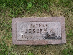
| Description | : | J.A. Eastwood of Pomona Dead James Abram Eastwood, 65 formerly principal of Pomona school, died yesterday at 9:10 a.m. at the home, death resulting from carcinoma. He was born July 30, 1883 at Liberty, Nebr., son of Henry Houtz and Mary Lucas (Kirkendall) Eastwood. He was married to Verna Margaret Aitken, August 14, 1906 at Winchester. The family moved to Pomona two years ago from Parker, and he was principal two years of the Pomona school. He had taught school in Kansas and Nebraska 45 years. He had an emeritus membership in Phi Delta Kappa chapter No. 523, and... Read More |
frequently asked questions (FAQ):
-
Where is James Abram Eastwood's memorial?
James Abram Eastwood's memorial is located at: Mission Creek Cemetery, Pawnee County, USA.
-
When did James Abram Eastwood death?
James Abram Eastwood death on 7 Nov 1948 in Pomona, Franklin County, Kansas, USA
-
Where are the coordinates of the James Abram Eastwood's memorial?
Latitude: 40.0149994
Longitude: -96.4263992
Family Members:
Parent

Spouse
Siblings
Children
Flowers:


Nearby Cemetories:
1. Mission Creek Cemetery
Pawnee County, USA
Coordinate: 40.0149994, -96.4263992
2. Tanner Cemetery
Pawnee County, USA
Coordinate: 40.0238991, -96.4143982
3. Mission Creek Cemetery
Marshall County, USA
Coordinate: 39.9866982, -96.4649963
4. Evangelical Lutheran Cemetery
Liberty, Gage County, USA
Coordinate: 40.0083300, -96.4825100
5. Richland Center Cemetery
Marshall County, USA
Coordinate: 39.9584000, -96.4073700
6. Summerfield Cemetery
Summerfield, Marshall County, USA
Coordinate: 40.0005989, -96.3422012
7. Holy Family Cemetery
Summerfield, Marshall County, USA
Coordinate: 39.9994011, -96.3414001
8. Liberty Cemetery
Liberty, Gage County, USA
Coordinate: 40.0772018, -96.4982986
9. Guittard Cemetery
Beattie, Marshall County, USA
Coordinate: 39.9094009, -96.4152985
10. North Elm Cemetery
Marshall County, USA
Coordinate: 39.9431000, -96.5325012
11. Saint Josephs Cemetery
Barneston, Gage County, USA
Coordinate: 40.0653000, -96.5757980
12. Barneston Cemetery
Barneston, Gage County, USA
Coordinate: 40.0661011, -96.5755997
13. West Branch Cemetery
Pawnee County, USA
Coordinate: 40.0787940, -96.2797160
14. Pleasant Hill Cemetery
Gage County, USA
Coordinate: 40.1462250, -96.4676820
15. Burchard Cemetery
Burchard, Pawnee County, USA
Coordinate: 40.1383018, -96.3538971
16. Shockleys Fairland Cemetery
Marshall County, USA
Coordinate: 39.9284500, -96.2866500
17. Johnson Creek Cemetery
Pawnee City, Pawnee County, USA
Coordinate: 40.0270000, -96.2465000
18. Sacred Heart Cemetery
Burchard, Pawnee County, USA
Coordinate: 40.1460991, -96.3683014
19. Madden Cemetery
Axtell, Marshall County, USA
Coordinate: 39.9866800, -96.2490300
20. Kinney Cemetery
Gage County, USA
Coordinate: 40.1102100, -96.5588800
21. Saint Bridget Cemetery
Axtell, Marshall County, USA
Coordinate: 39.9572000, -96.2578000
22. Oketo Cemetery
Oketo, Marshall County, USA
Coordinate: 39.9571991, -96.5950012
23. Beattie Union Cemetery
Beattie, Marshall County, USA
Coordinate: 39.8717003, -96.4207993
24. Saint Patricks Cemetery
Beattie, Marshall County, USA
Coordinate: 39.8703003, -96.4231033