
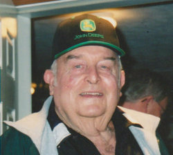
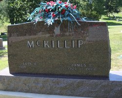
James Douglas McKillip
| Birth | : | 25 Dec 1925 Wabash County, Indiana, USA |
| Death | : | 26 Jun 2008 Wabash, Wabash County, Indiana, USA |
| Burial | : | Hokitika Municipal Cemetery, Hokitika, Westland District, New Zealand |
| Coordinate | : | -42.7102940, 170.9759800 |
| Plot | : | Sec 200, lot 796, sp 1 |
| Description | : | OBITUARY - Plain Dealer, Wabash (IN) James Douglas McKillip, 82, rural Wabash, died at 11:25 a.m. Thursday, June 26, 2008, at his home. He was born Dec. 25, 1925, in Wabash County to Alvin J. and Amanda (Shinn) McKillip. He married Lois Tomson in Wabash on Oct. 21, 1945, and she survives. He was a 1943 graduate of Chippewa High School and was a retired co-owner and co-founder of McKillip Seeds Inc., Wabash. Jim was a member of Bachelor Creek Church of Christ, the Hanna Masonic Lodge and the Shrine Club, all of Wabash, and the Fort... Read More |
frequently asked questions (FAQ):
-
Where is James Douglas McKillip's memorial?
James Douglas McKillip's memorial is located at: Hokitika Municipal Cemetery, Hokitika, Westland District, New Zealand.
-
When did James Douglas McKillip death?
James Douglas McKillip death on 26 Jun 2008 in Wabash, Wabash County, Indiana, USA
-
Where are the coordinates of the James Douglas McKillip's memorial?
Latitude: -42.7102940
Longitude: 170.9759800
Family Members:
Parent

Spouse

Siblings


Nearby Cemetories:
1. Hokitika Municipal Cemetery
Hokitika, Westland District, New Zealand
Coordinate: -42.7102940, 170.9759800
2. Old Stafford Cemetery
Hokitika, Westland District, New Zealand
Coordinate: -42.6662370, 171.0893140
3. Kumara Cemetery
Kumara, Westland District, New Zealand
Coordinate: -42.6464650, 171.1721970
4. Ross Cemetery
Ross, Westland District, New Zealand
Coordinate: -42.8898440, 170.8226160
5. Gladstone Cemetery
Greymouth, Grey District, New Zealand
Coordinate: -42.5381220, 171.1522540
6. Ross Historic Cemetery
Ross, Westland District, New Zealand
Coordinate: -42.9023200, 170.8113230
7. Greenstone Cemetery
Kumara, Westland District, New Zealand
Coordinate: -42.6361450, 171.2751350
8. Karoro Cemetery
Greymouth, Grey District, New Zealand
Coordinate: -42.4678260, 171.1893800
9. St Pauls Methodist Church (Defunct)
Greymouth, Grey District, New Zealand
Coordinate: -42.4500880, 171.2114610
10. Cobden Cemetery
Greymouth, Grey District, New Zealand
Coordinate: -42.4371700, 171.2019000
11. Stillwater Cemetery
Greymouth, Grey District, New Zealand
Coordinate: -42.4394820, 171.3494380
12. Notown Cemetery
Dobson, Grey District, New Zealand
Coordinate: -42.4514530, 171.4465670
13. Blackball Cemetery
Greymouth, Grey District, New Zealand
Coordinate: -42.3757410, 171.4135760
14. Evans Grave
Arthurs Pass, Selwyn District, New Zealand
Coordinate: -42.7723610, 171.6249940
15. Nelson Creek Cemetery
Ngahere, Grey District, New Zealand
Coordinate: -42.3865620, 171.4595500
16. Barrytown Cemetery
Barrytown, Grey District, New Zealand
Coordinate: -42.2455150, 171.3166710
17. Hari Hari Cemetery
Hari Hari, Westland District, New Zealand
Coordinate: -43.1501430, 170.5576110
18. Ahaura Cemetery
Ahaura, Grey District, New Zealand
Coordinate: -42.3516790, 171.5581700
19. Whataroa Cemetery
Whataroa, Westland District, New Zealand
Coordinate: -43.2530190, 170.3587130
20. Lake Coleridge Cemetery
Lake Coleridge, Selwyn District, New Zealand
Coordinate: -43.3695530, 171.5264300
21. Charleston Catholic Cemetery
Charleston, Buller District, New Zealand
Coordinate: -41.9093390, 171.4359110
22. Nile Hill Cemetery
Charleston, Buller District, New Zealand
Coordinate: -41.8991610, 171.4394080
23. Old Reefton Cemetery
Reefton, Buller District, New Zealand
Coordinate: -42.1115220, 171.8590850
24. Reefton Cemetery
Reefton, Buller District, New Zealand
Coordinate: -42.0856940, 171.8470730