
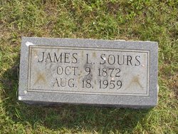
James Lester Sours
| Birth | : | 4 Oct 1872 Page County, Virginia, USA |
| Death | : | 18 Aug 1959 Frederick County, Virginia, USA |
| Burial | : | Alpine Center Cemetery, Comstock Park, Kent County, USA |
| Coordinate | : | 43.0724983, -85.7285995 |
frequently asked questions (FAQ):
-
Where is James Lester Sours's memorial?
James Lester Sours's memorial is located at: Alpine Center Cemetery, Comstock Park, Kent County, USA.
-
When did James Lester Sours death?
James Lester Sours death on 18 Aug 1959 in Frederick County, Virginia, USA
-
Where are the coordinates of the James Lester Sours's memorial?
Latitude: 43.0724983
Longitude: -85.7285995
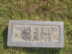
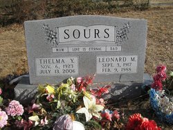
Family Members:
Parent

Spouse
Siblings
Children
Flowers:


Nearby Cemetories:
1. Alpine Center Cemetery
Comstock Park, Kent County, USA
Coordinate: 43.0724983, -85.7285995
2. Saur-Cross Cemetery
Walker, Kent County, USA
Coordinate: 43.0738890, -85.7569440
3. Holy Trinity Cemetery
Alpine Township, Kent County, USA
Coordinate: 43.0511017, -85.6992035
4. Pine Grove Cemetery
Comstock Park, Kent County, USA
Coordinate: 43.0757700, -85.6827600
5. Brooklawn Cemetery
Walker, Kent County, USA
Coordinate: 43.0280991, -85.7300034
6. Englishville Cemetery
Comstock Park, Kent County, USA
Coordinate: 43.1041985, -85.6800003
7. United Church of Christ Cemetery
Comstock Park, Kent County, USA
Coordinate: 43.0359210, -85.6684260
8. Mill Creek Cemetery
Walker, Kent County, USA
Coordinate: 43.0288890, -85.6705560
9. Saint Joseph Cemetery
Marne, Ottawa County, USA
Coordinate: 43.1107900, -85.8080400
10. Wells Cemetery
Wright Township, Ottawa County, USA
Coordinate: 43.0736008, -85.8266983
11. Grand Rapids Veterans Home Cemetery
Grand Rapids, Kent County, USA
Coordinate: 43.0182915, -85.6588898
12. Holy Cross Cemetery
Grand Rapids, Kent County, USA
Coordinate: 42.9953003, -85.7153015
13. Saints Peter and Paul Cemetery
Grand Rapids, Kent County, USA
Coordinate: 42.9963890, -85.6997220
14. Achim Cemetery
Grand Rapids, Kent County, USA
Coordinate: 42.9961014, -85.6994019
15. Garden of the Pines
Grand Rapids, Kent County, USA
Coordinate: 43.0422710, -85.6279260
16. Lithuanian Freedom Cemetery
Grand Rapids, Kent County, USA
Coordinate: 42.9956430, -85.6991170
17. Washington Park Memorial Gardens
Grand Rapids, Kent County, USA
Coordinate: 42.9944000, -85.7007980
18. Marne Cemetery
Marne, Ottawa County, USA
Coordinate: 43.0309810, -85.8238630
19. Lisbon Cemetery
Sparta, Kent County, USA
Coordinate: 43.1469002, -85.7791977
20. Fairplains Cemetery
Sparta, Kent County, USA
Coordinate: 43.1528015, -85.6988983
21. Greenwood Cemetery
Grand Rapids, Kent County, USA
Coordinate: 42.9892006, -85.7055969
22. Saint Andrews Episcopal Gardens
Grand Rapids, Kent County, USA
Coordinate: 43.0142030, -85.6430840
23. Assumption Cemetery
Belmont, Kent County, USA
Coordinate: 43.0783330, -85.6097220
24. Second Congregational UCC Memorial Garden
Grand Rapids, Kent County, USA
Coordinate: 43.0032900, -85.6549900