
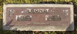
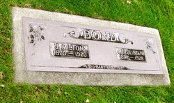
James Milton Bond
| Birth | : | 19 Jun 1876 Graham, Nodaway County, Missouri, USA |
| Death | : | 29 Jan 1920 Denver, Denver County, Colorado, USA |
| Burial | : | Ross Historic Cemetery, Ross, Westland District, New Zealand |
| Coordinate | : | -42.9023200, 170.8113230 |
| Plot | : | Block 23 |
frequently asked questions (FAQ):
-
Where is James Milton Bond's memorial?
James Milton Bond's memorial is located at: Ross Historic Cemetery, Ross, Westland District, New Zealand.
-
When did James Milton Bond death?
James Milton Bond death on 29 Jan 1920 in Denver, Denver County, Colorado, USA
-
Where are the coordinates of the James Milton Bond's memorial?
Latitude: -42.9023200
Longitude: 170.8113230
Family Members:
Parent

Spouse

Siblings
Children
Flowers:


Nearby Cemetories:
1. Ross Historic Cemetery
Ross, Westland District, New Zealand
Coordinate: -42.9023200, 170.8113230
2. Ross Cemetery
Ross, Westland District, New Zealand
Coordinate: -42.8898440, 170.8226160
3. Hokitika Municipal Cemetery
Hokitika, Westland District, New Zealand
Coordinate: -42.7102940, 170.9759800
4. Hari Hari Cemetery
Hari Hari, Westland District, New Zealand
Coordinate: -43.1501430, 170.5576110
5. Old Stafford Cemetery
Hokitika, Westland District, New Zealand
Coordinate: -42.6662370, 171.0893140
6. Kumara Cemetery
Kumara, Westland District, New Zealand
Coordinate: -42.6464650, 171.1721970
7. Greenstone Cemetery
Kumara, Westland District, New Zealand
Coordinate: -42.6361450, 171.2751350
8. Gladstone Cemetery
Greymouth, Grey District, New Zealand
Coordinate: -42.5381220, 171.1522540
9. Whataroa Cemetery
Whataroa, Westland District, New Zealand
Coordinate: -43.2530190, 170.3587130
10. Karoro Cemetery
Greymouth, Grey District, New Zealand
Coordinate: -42.4678260, 171.1893800
11. St Pauls Methodist Church (Defunct)
Greymouth, Grey District, New Zealand
Coordinate: -42.4500880, 171.2114610
12. Cobden Cemetery
Greymouth, Grey District, New Zealand
Coordinate: -42.4371700, 171.2019000
13. Stillwater Cemetery
Greymouth, Grey District, New Zealand
Coordinate: -42.4394820, 171.3494380
14. Evans Grave
Arthurs Pass, Selwyn District, New Zealand
Coordinate: -42.7723610, 171.6249940
15. Notown Cemetery
Dobson, Grey District, New Zealand
Coordinate: -42.4514530, 171.4465670
16. Blackball Cemetery
Greymouth, Grey District, New Zealand
Coordinate: -42.3757410, 171.4135760
17. Lake Coleridge Cemetery
Lake Coleridge, Selwyn District, New Zealand
Coordinate: -43.3695530, 171.5264300
18. Nelson Creek Cemetery
Ngahere, Grey District, New Zealand
Coordinate: -42.3865620, 171.4595500
19. Barrytown Cemetery
Barrytown, Grey District, New Zealand
Coordinate: -42.2455150, 171.3166710
20. Ahaura Cemetery
Ahaura, Grey District, New Zealand
Coordinate: -42.3516790, 171.5581700
21. Our Lady of the Snows Cemetery
Fox Glacier, Westland District, New Zealand
Coordinate: -43.4623130, 170.0077480
22. Upper Rangitata Cemetery
Rangitata, Timaru District, New Zealand
Coordinate: -43.7575112, 171.0907394
23. Gillespies Beach Miners Cemetery
Fox Glacier, Westland District, New Zealand
Coordinate: -43.4184830, 169.8219480
24. Alford Forest Cemetery
Alford Forest, Ashburton District, New Zealand
Coordinate: -43.6428200, 171.4933300