
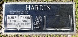
James Richard Hardin
| Birth | : | 31 Aug 1928 Tempe, Maricopa County, Arizona, USA |
| Death | : | 26 May 1987 Angwin, Napa County, California, USA |
| Burial | : | Grahamsville Rural Cemetery, Grahamsville, Sullivan County, USA |
| Coordinate | : | 41.8471985, -74.5381012 |
| Plot | : | Santa Cruz 2, Plot 287, Grave K |
| Description | : | James Richard Hardin, 58, died Tuesday in Angwin, Calif. A native of Tempe, Ariz., he was born Aug. 31, 1928, and had been a Reno resident for the past year, coming from Camarillo, Calif. Hardin received a degree in theology from Pacific Union College in Angwin and became a minister of the Seventh-day Adventist Church in Ridgecrest, Calif. He served as a pastor in Phoenix, Ariz., and several Southern California churches and held various offices within the church, the most recent being his 1985 appointment as president of the Nevada-Utah Conference. Hardin was one of the founders of Lancaster Community... Read More |
frequently asked questions (FAQ):
-
Where is James Richard Hardin's memorial?
James Richard Hardin's memorial is located at: Grahamsville Rural Cemetery, Grahamsville, Sullivan County, USA.
-
When did James Richard Hardin death?
James Richard Hardin death on 26 May 1987 in Angwin, Napa County, California, USA
-
Where are the coordinates of the James Richard Hardin's memorial?
Latitude: 41.8471985
Longitude: -74.5381012
Family Members:
Parent
Siblings

Flowers:


Nearby Cemetories:
1. Grahamsville Rural Cemetery
Grahamsville, Sullivan County, USA
Coordinate: 41.8471985, -74.5381012
2. Davenport Cemetery
Neversink, Sullivan County, USA
Coordinate: 41.8558100, -74.5948800
3. Van Tran Cemetery
Neversink, Sullivan County, USA
Coordinate: 41.8138800, -74.5819600
4. Teller Family Plot
Neversink, Sullivan County, USA
Coordinate: 41.8420100, -74.6062200
5. Benton Cemetery
Neversink, Sullivan County, USA
Coordinate: 41.8352130, -74.6067300
6. Mutton Hill Cemetery
Neversink, Sullivan County, USA
Coordinate: 41.8367160, -74.6199560
7. Red Hill Cemetery
Denning, Ulster County, USA
Coordinate: 41.9164300, -74.5126800
8. Claryville Reformed Church Cemetery
Claryville, Sullivan County, USA
Coordinate: 41.9160600, -74.5722500
9. Fallsburg Neversink Cemetery
Neversink, Sullivan County, USA
Coordinate: 41.8113400, -74.6353800
10. Misner Burying Ground
Woodbourne, Sullivan County, USA
Coordinate: 41.7766360, -74.6022990
11. Hillside Cemetery
Woodbourne, Sullivan County, USA
Coordinate: 41.7630300, -74.5991900
12. Woodbourne Reformed Cemetery
Woodbourne, Sullivan County, USA
Coordinate: 41.7624300, -74.5994800
13. Woodbourne Cemetery
Woodbourne, Sullivan County, USA
Coordinate: 41.7625200, -74.6003500
14. Congregation Knesset Israel Cemetery
Ellenville, Ulster County, USA
Coordinate: 41.7514870, -74.5030360
15. Hodge Cemetery
Neversink, Sullivan County, USA
Coordinate: 41.8439300, -74.6768500
16. Greenfield Methodist Ground
Ulster County, USA
Coordinate: 41.7292700, -74.5026500
17. Greenfield Quaker Cemetery
Greenfield Park, Ulster County, USA
Coordinate: 41.7267100, -74.4906500
18. Chesed Shel Emes Cemetery
Liberty, Sullivan County, USA
Coordinate: 41.7816630, -74.7008770
19. Ahavath Israel Cemetery
Liberty, Sullivan County, USA
Coordinate: 41.7828200, -74.7018600
20. Fallsburg Cemetery
Fallsburg, Sullivan County, USA
Coordinate: 41.7199200, -74.6108300
21. Sullivan County Veterans Cemetery
Liberty, Sullivan County, USA
Coordinate: 41.7920400, -74.7107100
22. Brown Settlement Cemetery
Rockland, Sullivan County, USA
Coordinate: 41.9287800, -74.6995900
23. Cherrytown Cemetery
Cherrytown, Ulster County, USA
Coordinate: 41.8320000, -74.3367100
24. Chesed Shel Emes Cemetery
Woodridge, Sullivan County, USA
Coordinate: 41.6937110, -74.5502380