
| Birth | : | 23 Aug 1938 Pittsburg, Crawford County, Kansas, USA |
| Death | : | 19 Dec 2003 Pittsburg, Crawford County, Kansas, USA |
| Burial | : | Farnworth Cemetery, Farnworth, Metropolitan Borough of Bolton, England |
| Coordinate | : | 53.5548590, -2.3843000 |
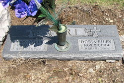
| Inscription | : | L CPL US MARINE CORPS |
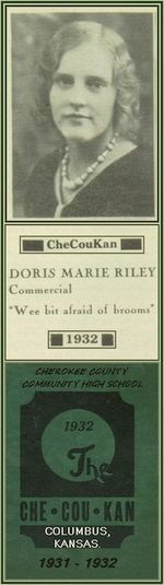
| Description | : | ~ ♪ ♫ ♩ ♬~ James Riley 'Bud' Iori ~♬♩ ♫ ♪ ~ (August 23, 1938 ~ December 19, 2003) *★* Veteran U.S. Marine Corps *★* James Riley Iori, 65, of 540 E. 24th St., Pittsburg, died at 2:30 p.m. Friday, Dec. 19, 2003, at his home. He was born Aug. 23, 1938, at Pittsburg, to Pierre Sylvester "Pete" and Doris Marie Riley Iori. He was a lifelong resident of Pittsburg. He graduated from St. Mary's High School in Pittsburg in 1956 and attended Pittsburg State University. Mr. Iori served in the... Read More |
frequently asked questions (FAQ):
-
Where is James Riley “Jim” Iori's memorial?
James Riley “Jim” Iori's memorial is located at: Farnworth Cemetery, Farnworth, Metropolitan Borough of Bolton, England.
-
When did James Riley “Jim” Iori death?
James Riley “Jim” Iori death on 19 Dec 2003 in Pittsburg, Crawford County, Kansas, USA
-
Where are the coordinates of the James Riley “Jim” Iori's memorial?
Latitude: 53.5548590
Longitude: -2.3843000
Family Members:
Parent
Siblings
Flowers:


Nearby Cemetories:
1. Farnworth Cemetery
Farnworth, Metropolitan Borough of Bolton, England
Coordinate: 53.5548590, -2.3843000
2. Market Street Congregational Churchyard
Farnworth, Metropolitan Borough of Bolton, England
Coordinate: 53.5475620, -2.3911703
3. St. Matthew Churchyard
Little Lever, Metropolitan Borough of Bolton, England
Coordinate: 53.5626144, -2.3732190
4. Christ Church Churchyard
Little Lever, Metropolitan Borough of Bolton, England
Coordinate: 53.5598101, -2.3692188
5. King's Church Chapelyard
Little Lever, Metropolitan Borough of Bolton, England
Coordinate: 53.5625122, -2.3716833
6. New Jerusalem Church Churchyard
Kearsley, Metropolitan Borough of Bolton, England
Coordinate: 53.5435770, -2.3877380
7. Kearsley New Church Burial Ground
Farnworth, Metropolitan Borough of Bolton, England
Coordinate: 53.5435500, -2.3879200
8. St John the Evangelist Churchyard
Farnworth, Metropolitan Borough of Bolton, England
Coordinate: 53.5491930, -2.4043350
9. St. Michael Churchyard
Great Lever, Metropolitan Borough of Bolton, England
Coordinate: 53.5603730, -2.4082370
10. St Stephen churchyard
Kearsley, Metropolitan Borough of Bolton, England
Coordinate: 53.5381650, -2.3717160
11. St Saviour churchyard
Ringley, Metropolitan Borough of Bolton, England
Coordinate: 53.5439030, -2.3576830
12. St James Churchyard
Farnworth, Metropolitan Borough of Bolton, England
Coordinate: 53.5423730, -2.4117570
13. St Stephen and All Martyrs Churchyard
Bolton, Metropolitan Borough of Bolton, England
Coordinate: 53.5722100, -2.4049800
14. Tonge Cemetery
Bolton, Metropolitan Borough of Bolton, England
Coordinate: 53.5782250, -2.4097050
15. St James Churchyard
Breightmet, Metropolitan Borough of Bolton, England
Coordinate: 53.5824000, -2.3922100
16. Holy Trinity Churchyard
Bolton, Metropolitan Borough of Bolton, England
Coordinate: 53.5738021, -2.4267218
17. St Paul Churchyard
Walkden, Metropolitan Borough of Salford, England
Coordinate: 53.5231133, -2.3947620
18. St. Andrew's Churchyard
Radcliffe, Metropolitan Borough of Bury, England
Coordinate: 53.5740731, -2.3377989
19. Mawdsley Street Congregational Churchyard
Bolton, Metropolitan Borough of Bolton, England
Coordinate: 53.5766862, -2.4277304
20. St Peter Churchyard
Bolton, Metropolitan Borough of Bolton, England
Coordinate: 53.5794060, -2.4235690
21. St. Paul's Churchyard
Little Hulton, Metropolitan Borough of Salford, England
Coordinate: 53.5309270, -2.4260100
22. St. Thomas & St. John with St. Philip Churchyard
Radcliffe, Metropolitan Borough of Bury, England
Coordinate: 53.5625140, -2.3266770
23. Ainsworth Methodist Churchyard
Ainsworth, Metropolitan Borough of Bury, England
Coordinate: 53.5877390, -2.3623810
24. Christ Church Churchyard
Ainsworth, Metropolitan Borough of Bury, England
Coordinate: 53.5875690, -2.3589540