
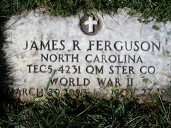

James Ross “Bud” Ferguson
| Birth | : | 29 Mar 1923 Liberty, Randolph County, North Carolina, USA |
| Death | : | 27 Nov 1957 Alamance County, North Carolina, USA |
| Burial | : | Fairview Cemetery, Liberty, Randolph County, USA |
| Coordinate | : | 35.8516998, -79.5761032 |
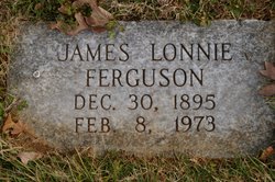
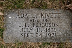
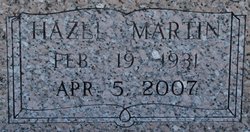
| Description | : | James was the third of four children born to James Lonnie and Ada L.(Kivett) Ferguson. He married Hazel Lee Martin and they had one daughter: Sandra Kay. Greensboro Daily News, NC November 28, 1957 Liberty Man Loses Life In Accident LIBERTY, Nov. 28 - A 34-year-old Liberty man was killed when thrown from his car as it overturned on Highway 49, about three and a half miles north of here last night. James Ross (Bud) Ferguson died of injuries received when his car landed on top of him, the Highway Patrol reported. He was employed by Gregerson Manufacturing Co., was a member of the First Methodist Church and... Read More |
frequently asked questions (FAQ):
-
Where is James Ross “Bud” Ferguson's memorial?
James Ross “Bud” Ferguson's memorial is located at: Fairview Cemetery, Liberty, Randolph County, USA.
-
When did James Ross “Bud” Ferguson death?
James Ross “Bud” Ferguson death on 27 Nov 1957 in Alamance County, North Carolina, USA
-
Where are the coordinates of the James Ross “Bud” Ferguson's memorial?
Latitude: 35.8516998
Longitude: -79.5761032
Family Members:
Parent
Spouse
Siblings


Nearby Cemetories:
1. Fairview Cemetery
Liberty, Randolph County, USA
Coordinate: 35.8516998, -79.5761032
2. Amos Grove Cemetery
Liberty, Randolph County, USA
Coordinate: 35.8546982, -79.5871964
3. Saint Stephen Memorial Gardens
Liberty, Randolph County, USA
Coordinate: 35.8550750, -79.5877970
4. Bethany United Methodist Church Cemetery #2
Liberty, Randolph County, USA
Coordinate: 35.8430060, -79.5948160
5. Liberty Grove Methodist Church Cemetery
Liberty, Randolph County, USA
Coordinate: 35.8733140, -79.5709950
6. Mount Pleasant Baptist Church Cemetery
Staley, Randolph County, USA
Coordinate: 35.8144700, -79.5790000
7. Margarets Chapel Church Cemetery
Staley, Randolph County, USA
Coordinate: 35.8110940, -79.5648900
8. Hickory Grove Methodist Church Cemetery
Albright Township, Chatham County, USA
Coordinate: 35.8407560, -79.5217650
9. Olivers Chapel Cemetery
Staley, Randolph County, USA
Coordinate: 35.8060989, -79.5610962
10. McMasters Cemetery
Randolph County, USA
Coordinate: 35.8072370, -79.6021500
11. Oak Grove Baptist Church Cemetery
Snow Camp, Alamance County, USA
Coordinate: 35.8873490, -79.5330180
12. Macedonia Baptist Church Cemetery
Liberty, Randolph County, USA
Coordinate: 35.8960090, -79.6075490
13. Richland Cemetery
Liberty, Randolph County, USA
Coordinate: 35.8996315, -79.5469894
14. Melanchthon Lutheran Church Cemetery
Liberty, Randolph County, USA
Coordinate: 35.8451630, -79.6440640
15. Sandy Creek Primitive Baptist Church Cemetery
Liberty, Randolph County, USA
Coordinate: 35.8239020, -79.6406560
16. Smithwood United Church of Christ Cemetery
Guilford County, USA
Coordinate: 35.9113900, -79.5605600
17. Sandy Creek Baptist Church Cemetery
Liberty, Randolph County, USA
Coordinate: 35.8235550, -79.6429050
18. Staley City Cemetery
Staley, Randolph County, USA
Coordinate: 35.7918300, -79.5507100
19. Lineberry Family Cemetery
Staley, Randolph County, USA
Coordinate: 35.7878000, -79.5724000
20. Old Shady Grove Cemetery
Staley, Randolph County, USA
Coordinate: 35.7874985, -79.5725021
21. Pleasant Union Pilgrim Holiness Church Cemetery
Snow Camp, Alamance County, USA
Coordinate: 35.8781350, -79.5011080
22. Shady Grove Baptist Church Cemetery
Staley, Randolph County, USA
Coordinate: 35.7853800, -79.5821020
23. Hollys Chapel Pentecostal Holiness Church
Ramseur, Randolph County, USA
Coordinate: 35.7825600, -79.6048200
24. Rocky River Baptist Church Cemetery
Crutchfield Crossroads, Chatham County, USA
Coordinate: 35.8222237, -79.4875031