
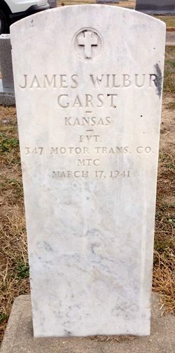

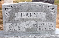
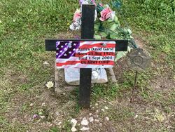
James Wilber Garst
| Birth | : | 28 Jan 1893 Glasco, Cloud County, Kansas, USA |
| Death | : | 17 Mar 1941 Wichita, Sedgwick County, Kansas, USA |
| Burial | : | Attwood Cemetery, Kidsgrove, Newcastle-Under-Lyme Borough, England |
| Coordinate | : | 53.0889200, -2.2350700 |
| Plot | : | 7GE17 |
| Description | : | Glasco Sun, Thursday, March 27, 1941, page 1: James Wilber Garst, son of Frank T. and Mary Garst was born at Glasco, Kansas, January 28, 1893, and passed away in the Veterans' Hospital, Wichita, Kansas on March 17, 1941 at the age of 48 years, 1 month and 20 days. He was reared and educated in this community and at the age of 18 he united with the Methodist church. On May 24, 1918, when he was 25, Mr. Garst was called into army service and was discharged May 15, 1919. On October 24, 1927 he was married to Beulah A. Stratton. Into... Read More |
frequently asked questions (FAQ):
-
Where is James Wilber Garst's memorial?
James Wilber Garst's memorial is located at: Attwood Cemetery, Kidsgrove, Newcastle-Under-Lyme Borough, England.
-
When did James Wilber Garst death?
James Wilber Garst death on 17 Mar 1941 in Wichita, Sedgwick County, Kansas, USA
-
Where are the coordinates of the James Wilber Garst's memorial?
Latitude: 53.0889200
Longitude: -2.2350700
Family Members:
Parent

Spouse
Siblings

Children
Flowers:


Nearby Cemetories:
1. St. James the Apostle Churchyard
Newchapel, Newcastle-Under-Lyme Borough, England
Coordinate: 53.0874630, -2.2069790
2. St. John the Evangelist Churchyard
Goldenhill, Stoke-on-Trent Unitary Authority, England
Coordinate: 53.0749010, -2.2189830
3. St Martin Churchyard
Talke, Newcastle-Under-Lyme Borough, England
Coordinate: 53.0755440, -2.2618170
4. All Saints Churchyard
Church Lawton, Cheshire East Unitary Authority, England
Coordinate: 53.0987050, -2.2679300
5. St Thomas Churchyard
Mow Cop, Newcastle-Under-Lyme Borough, England
Coordinate: 53.1127280, -2.2101350
6. Tunstall Cemetery
Tunstall, Stoke-on-Trent Unitary Authority, England
Coordinate: 53.0618690, -2.2180260
7. Christ Church Churchyard
Tunstall, Stoke-on-Trent Unitary Authority, England
Coordinate: 53.0625400, -2.2112840
8. All Saints Churchyard
Odd Rode, Cheshire East Unitary Authority, England
Coordinate: 53.1142100, -2.2644690
9. St Mary Magdalene Churchyard
Alsager, Cheshire East Unitary Authority, England
Coordinate: 53.0960640, -2.3071370
10. Audley Methodist Church Cemetery
Bignall End, Newcastle-Under-Lyme Borough, England
Coordinate: 53.0574320, -2.2944720
11. Holy Trinity Churchyard
Chesterton, Stratford-on-Avon District, England
Coordinate: 53.0418320, -2.2523770
12. Christ Church Churchyard
Alsager, Cheshire East Unitary Authority, England
Coordinate: 53.0977630, -2.3166660
13. St John the Baptist Churchyard
Burslem, Stoke-on-Trent Unitary Authority, England
Coordinate: 53.0425850, -2.1962510
14. St James the Great Churchyard
Audley, Newcastle-Under-Lyme Borough, England
Coordinate: 53.0548480, -2.3014800
15. Parish church of st saviour smallthorne
Smallthorne, Stoke-on-Trent Unitary Authority, England
Coordinate: 53.0497445, -2.1758707
16. St Bartholomew Churchyard
Norton in the Moors, Stoke-on-Trent Unitary Authority, England
Coordinate: 53.0604630, -2.1595270
17. Smallthorne Cemetery
Smallthorne, Stoke-on-Trent Unitary Authority, England
Coordinate: 53.0480310, -2.1765950
18. Chesterton Cemetery
Newcastle-under-Lyme, Newcastle-Under-Lyme Borough, England
Coordinate: 53.0352240, -2.2500500
19. St Anne Churchyard
Brown Edge, Staffordshire Moorlands District, England
Coordinate: 53.0832490, -2.1429880
20. Burslem Cemetery
Burslem, Stoke-on-Trent Unitary Authority, England
Coordinate: 53.0463020, -2.1747030
21. Audley Cemetery
Audley, Newcastle-Under-Lyme Borough, England
Coordinate: 53.0550140, -2.3103040
22. St. Lawrence Churchyard
Biddulph, Staffordshire Moorlands District, England
Coordinate: 53.1281320, -2.1659070
23. St John the Baptist Churchyard
Smallwood, Cheshire East Unitary Authority, England
Coordinate: 53.1381700, -2.2913100
24. St Margaret Churchyard
Wolstanton, Newcastle-Under-Lyme Borough, England
Coordinate: 53.0296810, -2.2154990