
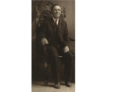
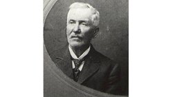

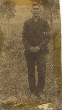
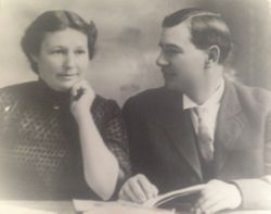
James William “Diamond R” Brown II
| Birth | : | 5 Sep 1841 Hillsboro, Highland County, Ohio, USA |
| Death | : | 23 Dec 1927 Browning, Glacier County, Montana, USA |
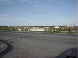
| Burial | : | St. James' Churchyard, South Stoke, Bath and North East Somerset Unitary Authority, England |
| Coordinate | : | 51.3497220, -2.3652780 |
| Description | : | James W. Brown II, after attending the public schools of Hillsboro, left home in 1858 and for three years labored in Illinois as a farm hand. At age 21 he was 5' 6" in height with black hair. At the first call for troops in the Civil War, he enlisted in the Twentieth Illinois Infantry and served from June, 1861, until July, 1864. He was wounded at Fort Donelson, Shiloh and Vicksburg. After his muster-out at Nashville, Tenn., in February, 1865, he re-enlisted for a year in the Fourth Veteran Regiment, Hancock's corps, and was in camp at... Read More |
frequently asked questions (FAQ):
-
Where is James William “Diamond R” Brown II's memorial?
James William “Diamond R” Brown II's memorial is located at: St. James' Churchyard, South Stoke, Bath and North East Somerset Unitary Authority, England.
-
When did James William “Diamond R” Brown II death?
James William “Diamond R” Brown II death on 23 Dec 1927 in Browning, Glacier County, Montana, USA
-
Where are the coordinates of the James William “Diamond R” Brown II's memorial?
Latitude: 51.3497220
Longitude: -2.3652780
Family Members:
Parent
Spouse
Siblings
Children
Flowers:


Nearby Cemetories:
1. St. James' Churchyard
South Stoke, Bath and North East Somerset Unitary Authority, England
Coordinate: 51.3497220, -2.3652780
2. Bath Union Workhouse Graveyard
Bath, Bath and North East Somerset Unitary Authority, England
Coordinate: 51.3584160, -2.3711140
3. Bath Union Workhouse Burial Ground
Bath, Bath and North East Somerset Unitary Authority, England
Coordinate: 51.3570889, -2.3773370
4. Jewish Burial Ground
Combe Down, Bath and North East Somerset Unitary Authority, England
Coordinate: 51.3599170, -2.3534670
5. Combe Hay Cemetery
Combe Hay, Bath and North East Somerset Unitary Authority, England
Coordinate: 51.3397819, -2.3814323
6. Combe Hay Parish Churchyard
Combe Hay, Bath and North East Somerset Unitary Authority, England
Coordinate: 51.3371120, -2.3817390
7. Union Chapel
Combe Down, Bath and North East Somerset Unitary Authority, England
Coordinate: 51.3594751, -2.3443662
8. Midford Burial Ground
Bath, Bath and North East Somerset Unitary Authority, England
Coordinate: 51.3394360, -2.3391424
9. Prior Park College
Bath, Bath and North East Somerset Unitary Authority, England
Coordinate: 51.3645990, -2.3442400
10. Unitarian Chapel Burial Ground
Widcombe, Bath and North East Somerset Unitary Authority, England
Coordinate: 51.3704650, -2.3539270
11. St John the Evangelist Cemetery
Bath, Bath and North East Somerset Unitary Authority, England
Coordinate: 51.3696700, -2.3487400
12. St. Michael's Churchyard
Monkton Combe, Bath and North East Somerset Unitary Authority, England
Coordinate: 51.3559540, -2.3285700
13. Bath Abbey Cemetery
Widcombe, Bath and North East Somerset Unitary Authority, England
Coordinate: 51.3712850, -2.3483060
14. St Julian's Churchyard
Wellow, Bath and North East Somerset Unitary Authority, England
Coordinate: 51.3240160, -2.3717630
15. St Mary Magdalen Chapel
Widcombe, Bath and North East Somerset Unitary Authority, England
Coordinate: 51.3760486, -2.3643405
16. St Thomas à Becket's Church
Widcombe, Bath and North East Somerset Unitary Authority, England
Coordinate: 51.3734250, -2.3465560
17. Abbey & St James' Graveyard for the Poor
Widcombe, Bath and North East Somerset Unitary Authority, England
Coordinate: 51.3753550, -2.3545640
18. Quaker Burial Ground
Widcombe, Bath and North East Somerset Unitary Authority, England
Coordinate: 51.3744350, -2.3498460
19. Old Baptist Burial Ground
Walcot, Bath and North East Somerset Unitary Authority, England
Coordinate: 51.3755070, -2.3544360
20. Saint Mark's Churchyard
Widcombe, Bath and North East Somerset Unitary Authority, England
Coordinate: 51.3766660, -2.3588010
21. Baptist Burial Ground
Widcombe, Bath and North East Somerset Unitary Authority, England
Coordinate: 51.3764216, -2.3556947
22. Smallcombe Vale Cemetery
Bathwick, Bath and North East Somerset Unitary Authority, England
Coordinate: 51.3757400, -2.3429400
23. St James Old Burial Ground
Bath, Bath and North East Somerset Unitary Authority, England
Coordinate: 51.3798600, -2.3610100
24. St. Mary The Virgin Churchyard
Bathwick, Bath and North East Somerset Unitary Authority, England
Coordinate: 51.3759930, -2.3411930