

Jaretha T. “Jeefie” Jarrett Beley
| Birth | : | 5 Oct 1914 Sweet Grass County, Montana, USA |
| Death | : | 28 Apr 1986 Big Timber, Sweet Grass County, Montana, USA |
| Burial | : | Osawatomie Cemetery, Osawatomie, Miami County, USA |
| Coordinate | : | 38.5355988, -94.9377975 |
| Plot | : | Section 6, Block 3D, Lot 2, Grave 5 |
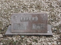
| Description | : | Jaretha Beley, 71, passed away Monday night at Sweet Grass Comunity Hospital in Big Timber. She was born October 5, 1914, in Big Timber, Montana, a daughter of Mr. and Mrs. Ralph S. Jarrett. The family ranched in the Duck Creek area. She attended schools in Big Timber and graduated from Sweet Grass County High School. On January 11, 1936, she was married to Hans Beley in Bozeman, Montana. They ranched on Beley Whitetail Ranch for one year before moving to their present ranch on Big Timber Creek. Mrs. Beley enjoyed her family and enjoyed... Read More |
frequently asked questions (FAQ):
-
Where is Jaretha T. “Jeefie” Jarrett Beley's memorial?
Jaretha T. “Jeefie” Jarrett Beley's memorial is located at: Osawatomie Cemetery, Osawatomie, Miami County, USA.
-
When did Jaretha T. “Jeefie” Jarrett Beley death?
Jaretha T. “Jeefie” Jarrett Beley death on 28 Apr 1986 in Big Timber, Sweet Grass County, Montana, USA
-
Where are the coordinates of the Jaretha T. “Jeefie” Jarrett Beley's memorial?
Latitude: 38.5355988
Longitude: -94.9377975
Family Members:
Parent

Spouse
Siblings
Flowers:


Nearby Cemetories:
1. Osawatomie Cemetery
Osawatomie, Miami County, USA
Coordinate: 38.5355988, -94.9377975
2. Miami Memorial Gardens
Paola, Miami County, USA
Coordinate: 38.5337100, -94.9221400
3. Osawatomie State Hospital Burial Ground
Osawatomie, Miami County, USA
Coordinate: 38.5128600, -94.9326300
4. Elmdale Cemetery
Osawatomie, Miami County, USA
Coordinate: 38.5017014, -94.9381027
5. Oakwood Cemetery
Osawatomie, Miami County, USA
Coordinate: 38.5024300, -94.9510300
6. Brown Cemetery
Osawatomie, Miami County, USA
Coordinate: 38.4980300, -94.9566500
7. Paola Cemetery
Paola, Miami County, USA
Coordinate: 38.5704000, -94.8873000
8. Indianapolis Cemetery
Osawatomie, Miami County, USA
Coordinate: 38.5046997, -94.9931030
9. Miami County Poor Farm Cemetery
Paola, Miami County, USA
Coordinate: 38.5943420, -94.9193018
10. Ursuline Cemetery
Paola, Miami County, USA
Coordinate: 38.5678500, -94.8676400
11. Mannen Cemetery
Stanton, Miami County, USA
Coordinate: 38.5731010, -95.0113983
12. Holy Cross Cemetery
Paola, Miami County, USA
Coordinate: 38.5628014, -94.8482971
13. Whiteford Cemetery
Osawatomie, Miami County, USA
Coordinate: 38.4618988, -94.8992004
14. Mount Nebo Family Cemetery
Osawatomie Township, Miami County, USA
Coordinate: 38.4540400, -94.9208400
15. Crescent Hill Cemetery
Osawatomie, Miami County, USA
Coordinate: 38.4513700, -94.9705800
16. Debrick Cemetery
Miami County, USA
Coordinate: 38.4757996, -94.8432999
17. Stanton Cemetery
Stanton, Miami County, USA
Coordinate: 38.5426000, -95.0596100
18. Frank Cemetery
Block, Miami County, USA
Coordinate: 38.5270400, -94.8033500
19. Green Valley Cemetery
Miami County, USA
Coordinate: 38.4700012, -95.0472031
20. Shively Cemetery
Rantoul, Franklin County, USA
Coordinate: 38.5159500, -95.0747400
21. Block Trinity Lutheran Cemetery
Block, Miami County, USA
Coordinate: 38.4944400, -94.8086900
22. Spring Grove Quaker Cemetery
Miami County, USA
Coordinate: 38.4409600, -95.0185100
23. Sidney Shields Gravesite
Miami County, USA
Coordinate: 38.5447700, -94.7922700
24. Scott Valley Cemetery
Paola, Miami County, USA
Coordinate: 38.6521400, -94.9374200