

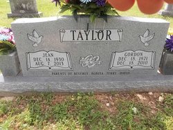
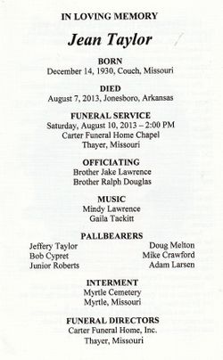

Jean Langston Taylor
| Birth | : | 14 Dec 1930 |
| Death | : | 7 Aug 2013 |
| Burial | : | Myrtle Cemetery, Myrtle, Oregon County, USA |
| Coordinate | : | 36.5133900, -91.2664300 |
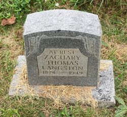
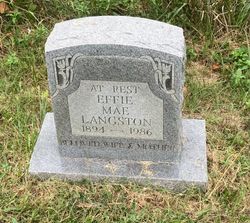
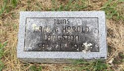
| Description | : | Jean Taylor was born the daughter of Zachary Thomas Langston and Effie Mae (Harper) Langston on December 14, 1930 in Couch, Missouri and departed this life August 7, 2013 in Jonesboro, Arkansas at the age of 82 years. She was united in marriage December 4, 1948 at Wirth, Arkansas to Gordon Eugene Taylor, who preceded her in death on December 18, 2010. She was preceded in death by her parents; one daughter, Beverly Taylor; one great grandchild, Aiden McIntosh; one sister, Gerry Lassiter; one brother, Edsel Langston; two infant brothers, Earl and Harvell Langston; and special friend, Lucille Cypret. Jean enjoyed growing flowers,... Read More |
frequently asked questions (FAQ):
-
Where is Jean Langston Taylor's memorial?
Jean Langston Taylor's memorial is located at: Myrtle Cemetery, Myrtle, Oregon County, USA.
-
When did Jean Langston Taylor death?
Jean Langston Taylor death on 7 Aug 2013 in
-
Where are the coordinates of the Jean Langston Taylor's memorial?
Latitude: 36.5133900
Longitude: -91.2664300
Family Members:
Parent
Spouse

Siblings


Nearby Cemetories:
1. Myrtle Cemetery
Myrtle, Oregon County, USA
Coordinate: 36.5133900, -91.2664300
2. Church of God Cemetery
Oregon County, USA
Coordinate: 36.5023500, -91.2580200
3. Byrd Cemetery
Myrtle, Oregon County, USA
Coordinate: 36.5186005, -91.3143997
4. Crass Homestead
Myrtle, Oregon County, USA
Coordinate: 36.5359695, -91.3084671
5. Old Elmore Thomas field
Billmore, Oregon County, USA
Coordinate: 36.5237770, -91.1980250
6. Spring Valley Cemetery
Billmore, Oregon County, USA
Coordinate: 36.5324670, -91.2003420
7. Guiteau-Risner Cemetery
Guiteau, Oregon County, USA
Coordinate: 36.5588074, -91.3156128
8. Walnut Grove Cemetery
Elm Store, Randolph County, USA
Coordinate: 36.4914017, -91.1967010
9. O'Neal
Billmore, Oregon County, USA
Coordinate: 36.5712170, -91.2415410
10. Cotton Creek Cemetery
Jobe, Oregon County, USA
Coordinate: 36.5844002, -91.2652969
11. John Brown Cemetery
Jobe, Oregon County, USA
Coordinate: 36.5812111, -91.2953568
12. James Cemetery
Randolph County, USA
Coordinate: 36.4660988, -91.3435974
13. Old Jobe Cemetery
Jobe, Oregon County, USA
Coordinate: 36.5917015, -91.2517014
14. Mount Carmel Cemetery
Calm, Oregon County, USA
Coordinate: 36.5106010, -91.1643982
15. Taylor Cemetery
Ravenden Springs, Randolph County, USA
Coordinate: 36.4468994, -91.3293991
16. Garfield Cemetery
Garfield, Oregon County, USA
Coordinate: 36.5844400, -91.3253400
17. Mosely Cemetery
Randolph County, USA
Coordinate: 36.4460983, -91.1975021
18. Davis Cemetery
Sharp County, USA
Coordinate: 36.4606018, -91.3574982
19. Reynolds Cemetery
Elm Store, Randolph County, USA
Coordinate: 36.4491997, -91.1860962
20. Pigman Mound Archeological Site
Calm, Oregon County, USA
Coordinate: 36.5717100, -91.1784800
21. Stubblefield Cemetery
Dalton, Randolph County, USA
Coordinate: 36.4597015, -91.1718979
22. Bellah Cemetery
Ravenden Springs, Randolph County, USA
Coordinate: 36.4207993, -91.2825012
23. Arytown Cemetery
Arytown, Oregon County, USA
Coordinate: 36.5539513, -91.3795776
24. Liberty Cemetery
Calm, Oregon County, USA
Coordinate: 36.5586500, -91.1549600