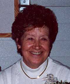
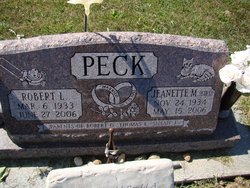
Jeanette Bird Peck
| Birth | : | 24 Nov 1934 Muscatine, Muscatine County, Iowa, USA |
| Death | : | 15 May 2006 Montpelier, Muscatine County, Iowa, USA |
| Burial | : | Methodist Church Churchyard, Griffydam, North West Leicestershire District, England |
| Coordinate | : | 52.7629060, -1.3894370 |
| Description | : | Funeral services to Celebrate the Life of Jeanette Peck, 71, a resident of Montpelier will be 10:00 a.m. Friday, May 19, 2006 at St. Andrew Catholic Church, 333 W. Lotte Street, Blue Grass, Iowa. Burial will be in Montpelier Cemetery. Visitation will be Thursday from 3:00 until 7:00 p.m. at the Halligan-McCabe-DeVries Funeral Home. Jeanette died on Monday, May 15, 2006 at her residence in Montpelier. She was surrounded by her loving family and passed following an extended and courageous battle with cancer. Medrith Jeanette Bird was born November 24, 1934 in Muscatine, Iowa a daughter of Les and Medrith... Read More |
frequently asked questions (FAQ):
-
Where is Jeanette Bird Peck's memorial?
Jeanette Bird Peck's memorial is located at: Methodist Church Churchyard, Griffydam, North West Leicestershire District, England.
-
When did Jeanette Bird Peck death?
Jeanette Bird Peck death on 15 May 2006 in Montpelier, Muscatine County, Iowa, USA
-
Where are the coordinates of the Jeanette Bird Peck's memorial?
Latitude: 52.7629060
Longitude: -1.3894370
Family Members:
Flowers:
Nearby Cemetories:
1. Methodist Church Churchyard
Griffydam, North West Leicestershire District, England
Coordinate: 52.7629060, -1.3894370
2. St George Churchyard
Swannington, North West Leicestershire District, England
Coordinate: 52.7530997, -1.3865110
3. St. Andrew's Churchyard
Thringstone, North West Leicestershire District, England
Coordinate: 52.7529090, -1.3692140
4. St Mary the Blessed Virgin Church
Osgathorpe, North West Leicestershire District, England
Coordinate: 52.7715890, -1.3623270
5. Grace-Dieu Priory
Thringstone, North West Leicestershire District, England
Coordinate: 52.7609720, -1.3566830
6. St. John Churchyard
Coleorton, North West Leicestershire District, England
Coordinate: 52.7486100, -1.4124400
7. St. Mary's Churchyard
Coleorton, North West Leicestershire District, England
Coordinate: 52.7513600, -1.4224500
8. Whitwick Cemetery
Whitwick, North West Leicestershire District, England
Coordinate: 52.7395560, -1.3623360
9. St John the Baptist Churchyard
Whitwick, North West Leicestershire District, England
Coordinate: 52.7416040, -1.3571200
10. Staunton Harold Churchyard
Ashby-de-la-Zouch, North West Leicestershire District, England
Coordinate: 52.7840510, -1.4381150
11. Holy Trinity Churchyard
Staunton Harold, North West Leicestershire District, England
Coordinate: 52.7841040, -1.4381631
12. St John Churchyard
Belton, North West Leicestershire District, England
Coordinate: 52.7830810, -1.3374590
13. Christ Church
Coalville, North West Leicestershire District, England
Coordinate: 52.7229610, -1.3673630
14. St. Michael and All Angels Churchyard
Ravenstone, North West Leicestershire District, England
Coordinate: 52.7214130, -1.4063470
15. London Road Cemetery
Coalville, North West Leicestershire District, England
Coordinate: 52.7222620, -1.3647710
16. Breedon Priory
Breedon on the Hill, North West Leicestershire District, England
Coordinate: 52.8060120, -1.3999600
17. Mount St Bernard Abbey
Whitwick, North West Leicestershire District, England
Coordinate: 52.7413880, -1.3234470
18. Broomleys Cemetery
Coalville, North West Leicestershire District, England
Coordinate: 52.7255540, -1.3402280
19. St. Helen's Churchyard
Ashby-de-la-Zouch, North West Leicestershire District, England
Coordinate: 52.7473020, -1.4669660
20. Holy Trinity
Ashby-de-la-Zouch, North West Leicestershire District, England
Coordinate: 52.7460010, -1.4757090
21. Shepshed Cemetery
Shepshed, Charnwood Borough, England
Coordinate: 52.7640470, -1.2963120
22. Ashby De La Zouch Cemetery
Ashby-de-la-Zouch, North West Leicestershire District, England
Coordinate: 52.7460403, -1.4794090
23. Hugglescote Cemetery
Coalville, North West Leicestershire District, England
Coordinate: 52.7067040, -1.3718090
24. St. James the Greater Oaks in Charnwood
Whitwick, North West Leicestershire District, England
Coordinate: 52.7425430, -1.3008590


