
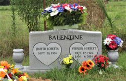

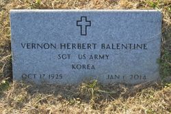
Jenifer Loretta Gammill Balentine
| Birth | : | 30 Sep 1934 Timbo, Stone County, Arkansas, USA |
| Death | : | 1 Aug 2021 Aurora, Lawrence County, Missouri, USA |
| Burial | : | Pordue Cemetery, Onia, Stone County, USA |
| Coordinate | : | 35.9254570, -92.3305130 |
| Description | : | Loretta Gammill Balentine of Verona, MO September 30, 1934 - August 1, 2021 Jenifer Loretta (Gammill) Balentine, age 86, passed away Sunday, August 1st, 2021. She was a resident at the Aurora Nursing Center in Aurora, Missouri. Loretta was born September 30th, 1934, in Timbo, Arkansas to Virgil Odis and Verdia (Goodman) Gammill. After graduating from Timbo High School, she met her future husband, Vernon Herbert Balentine, at the Rainbow Café in Mountain View, Arkansas, where she worked as a waitress. After their marriage, they moved to the Peoria, Illinois, area where Vernon worked for 32 years... Read More |
frequently asked questions (FAQ):
-
Where is Jenifer Loretta Gammill Balentine's memorial?
Jenifer Loretta Gammill Balentine's memorial is located at: Pordue Cemetery, Onia, Stone County, USA.
-
When did Jenifer Loretta Gammill Balentine death?
Jenifer Loretta Gammill Balentine death on 1 Aug 2021 in Aurora, Lawrence County, Missouri, USA
-
Where are the coordinates of the Jenifer Loretta Gammill Balentine's memorial?
Latitude: 35.9254570
Longitude: -92.3305130
Family Members:
Parent

Spouse
Siblings
Flowers:


Nearby Cemetories:
1. Pordue Cemetery
Onia, Stone County, USA
Coordinate: 35.9254570, -92.3305130
2. Farris Cemetery
Onia, Stone County, USA
Coordinate: 35.9303017, -92.3555984
3. Smithee Cemetery
Stone County, USA
Coordinate: 35.9199982, -92.3028030
4. Stevens Cemetery
Onia, Stone County, USA
Coordinate: 35.9594002, -92.3043976
5. Alco Cemetery
Alco, Stone County, USA
Coordinate: 35.8913994, -92.3783035
6. Brown Family Cemetery
Onia, Stone County, USA
Coordinate: 35.8782710, -92.3024940
7. Freeman Cemetery
Stone County, USA
Coordinate: 35.9508018, -92.3897018
8. Timbo Cemetery
Timbo, Stone County, USA
Coordinate: 35.8717200, -92.3189200
9. Big Springs Cemetery
Newnata, Stone County, USA
Coordinate: 35.9001200, -92.2683800
10. Wallis Cemetery
Alco, Stone County, USA
Coordinate: 35.9505900, -92.4052120
11. Ramsey Cemetery
Stone County, USA
Coordinate: 35.8583794, -92.3183746
12. Ramsley Cemetery
Stone County, USA
Coordinate: 35.8581009, -92.3182983
13. Cooper Hill Cemetery
Newnata, Stone County, USA
Coordinate: 35.8912400, -92.2578400
14. Nancy Lindsey Cemetery
Fiftysix, Stone County, USA
Coordinate: 35.9882164, -92.2935715
15. Blue Mountain Cemetery
Timbo, Stone County, USA
Coordinate: 35.8657074, -92.2817993
16. Oak Grove Cemetery
Newnata, Stone County, USA
Coordinate: 35.9065000, -92.2443000
17. Rorie Homeplace Cemetery
Fiftysix, Stone County, USA
Coordinate: 35.9946220, -92.2890190
18. Stevens Cemetery
Fiftysix, Stone County, USA
Coordinate: 35.9836006, -92.2677994
19. Spoonflat Cemetery
Fiftysix, Stone County, USA
Coordinate: 35.9838000, -92.2677000
20. Harmon Cemetery
Fiftysix, Stone County, USA
Coordinate: 35.9692190, -92.2511670
21. Happy Hollow Cemetery
Timbo, Stone County, USA
Coordinate: 35.8577530, -92.2667880
22. Passmore Cemetery
Thola, Searcy County, USA
Coordinate: 35.8885994, -92.4257965
23. McDaniel Cemetery
Thola, Searcy County, USA
Coordinate: 35.9000015, -92.4321976
24. Norman-Rorie Cemetery
Big Flat, Baxter County, USA
Coordinate: 36.0099590, -92.3577370