
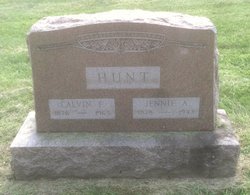
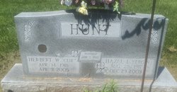
Jennie Alice Baer Hunt
| Birth | : | 12 Feb 1878 White County, Indiana, USA |
| Death | : | 26 Dec 1943 White County, Indiana, USA |
| Burial | : | Friends Burial Ground at Calversike Hill, Kildwick, Craven District, England |
| Coordinate | : | 53.8661050, -1.9195670 |
frequently asked questions (FAQ):
-
Where is Jennie Alice Baer Hunt's memorial?
Jennie Alice Baer Hunt's memorial is located at: Friends Burial Ground at Calversike Hill, Kildwick, Craven District, England.
-
When did Jennie Alice Baer Hunt death?
Jennie Alice Baer Hunt death on 26 Dec 1943 in White County, Indiana, USA
-
Where are the coordinates of the Jennie Alice Baer Hunt's memorial?
Latitude: 53.8661050
Longitude: -1.9195670
Family Members:
Spouse

Children
Flowers:


Nearby Cemetories:
1. Friends Burial Ground at Calversike Hill
Kildwick, Craven District, England
Coordinate: 53.8661050, -1.9195670
2. Keighley Shared Churchyard
Keighley, Metropolitan Borough of Bradford, England
Coordinate: 53.8651000, -1.9095580
3. St. John the Evangelist Churchyard
Ingrow, Metropolitan Borough of Bradford, England
Coordinate: 53.8552100, -1.9163280
4. Utley Cemetery
Keighley, Metropolitan Borough of Bradford, England
Coordinate: 53.8809160, -1.9141230
5. Laycock Wesleyan Methodist Cemetery
Laycock, Metropolitan Borough of Bradford, England
Coordinate: 53.8651200, -1.9527500
6. St Mary the Virgin Churchyard
Riddlesden, Metropolitan Borough of Bradford, England
Coordinate: 53.8801100, -1.8833100
7. Slack Lane Baptist Cemetery
Oakworth, Metropolitan Borough of Bradford, England
Coordinate: 53.8527400, -1.9568800
8. Oakworth Wesleyan Methodist Cemetery
Oakworth, Metropolitan Borough of Bradford, England
Coordinate: 53.8454920, -1.9493540
9. Christ Church Churchyard
Oakworth, Metropolitan Borough of Bradford, England
Coordinate: 53.8459200, -1.9549100
10. Morton Cemetery
Keighley, Metropolitan Borough of Bradford, England
Coordinate: 53.8730450, -1.8688400
11. Oakworth Crematorium
Keighley, Metropolitan Borough of Bradford, England
Coordinate: 53.8499320, -1.9661240
12. Harden Rycroft Primitive Methodist Church
Keighley, Metropolitan Borough of Bradford, England
Coordinate: 53.8385220, -1.8830690
13. St. Stephen Churchyard
Steeton, Metropolitan Borough of Bradford, England
Coordinate: 53.8968600, -1.9499600
14. St Luke Churchyard
East Morton, Metropolitan Borough of Bradford, England
Coordinate: 53.8726100, -1.8538200
15. St. John the Evangelist Churchyard
Cullingworth, Metropolitan Borough of Bradford, England
Coordinate: 53.8282300, -1.8991300
16. West Lane Baptist Chapel
Haworth, Metropolitan Borough of Bradford, England
Coordinate: 53.8324090, -1.9586480
17. St. Michael and All Angels Churchyard
Haworth, Metropolitan Borough of Bradford, England
Coordinate: 53.8311500, -1.9562350
18. Hall Green Baptist Chapel
Haworth, Metropolitan Borough of Bradford, England
Coordinate: 53.8285280, -1.9528130
19. East Morton, Primitive Methodist Chapel
East Morton, Metropolitan Borough of Bradford, England
Coordinate: 53.8755730, -1.8486880
20. Silsden Cemetery
Silsden, Metropolitan Borough of Bradford, England
Coordinate: 53.9106500, -1.9267000
21. Haworth Cemetery
Haworth, Metropolitan Borough of Bradford, England
Coordinate: 53.8301460, -1.9679580
22. Bingley Cemetery
Bingley, Metropolitan Borough of Bradford, England
Coordinate: 53.8534820, -1.8429860
23. All Saints Churchyard
Bingley, Metropolitan Borough of Bradford, England
Coordinate: 53.8516480, -1.8405650
24. St James Churchyard
Silsden, Metropolitan Borough of Bradford, England
Coordinate: 53.9139070, -1.9390650