
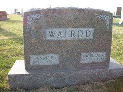
Jennie Elmina Mitchell-Black Walrod
| Birth | : | 1877 |
| Death | : | 1943 |
| Burial | : | Greenfield Cemetery, Knierim, Calhoun County, USA |
| Coordinate | : | 42.4495000, -94.4565000 |
| Description | : | The 6 children of Nicholas A. Walrod and Jennie Almina Mitchell-Black , 1. Agnes Catharine, on Sept. 29, 1897, md Oct. 7, 1924, to Christian Henry Mortensen. Their children, Shirley Ann, bn May 17, 1925; Doris Janet, bn Dec. 23, 1927; Ardis Marie, bn Aug. 11, 1929; Marilyn Christine, bn Mch. 25, 1931; Chas. Nicholas, bn May 25, 1933 and Ester Agnes, born Jan. 3, 1941, 2. John Philip, on Jan, 5,1899., md Sept. 17, 1924, to Violet May Stringer. Their children, Jennie Rose, b_ Jan. 16, 1925; Luella, bn Nov. 22, 1927; Eva Lee, on July 1, 1930 and John Elwood,... Read More |
frequently asked questions (FAQ):
-
Where is Jennie Elmina Mitchell-Black Walrod's memorial?
Jennie Elmina Mitchell-Black Walrod's memorial is located at: Greenfield Cemetery, Knierim, Calhoun County, USA.
-
When did Jennie Elmina Mitchell-Black Walrod death?
Jennie Elmina Mitchell-Black Walrod death on 1943 in
-
Where are the coordinates of the Jennie Elmina Mitchell-Black Walrod's memorial?
Latitude: 42.4495000
Longitude: -94.4565000
Family Members:
Spouse

Children
Flowers:


Nearby Cemetories:
1. Greenfield Cemetery
Knierim, Calhoun County, USA
Coordinate: 42.4495000, -94.4565000
2. Trinity Cemetery
Calhoun County, USA
Coordinate: 42.4747200, -94.4555588
3. Calvary Presbyterian Cemetery
Barnum, Webster County, USA
Coordinate: 42.4742810, -94.3835020
4. Hope Cemetery
Manson, Calhoun County, USA
Coordinate: 42.4994011, -94.5199966
5. Fulton Lutheran Cemetery
Roelyn, Webster County, USA
Coordinate: 42.4263992, -94.3688965
6. Rose Hill Cemetery
Manson, Calhoun County, USA
Coordinate: 42.5228004, -94.5243988
7. Saint Josephs Cemetery
Barnum, Webster County, USA
Coordinate: 42.5172000, -94.3769000
8. Leith Cemetery
Manson, Calhoun County, USA
Coordinate: 42.4878006, -94.5667038
9. Mizpah Cemetery
Webster County, USA
Coordinate: 42.3835983, -94.3707962
10. Saint Thomas Cemetery
Manson, Calhoun County, USA
Coordinate: 42.5208500, -94.5365000
11. Roland Township Cemetery
Slifer, Webster County, USA
Coordinate: 42.3685989, -94.3685989
12. Cedar Cemetery
Rinard, Calhoun County, USA
Coordinate: 42.3456001, -94.4644012
13. Fulton Township Cemetery
Moorland, Webster County, USA
Coordinate: 42.4272000, -94.3159000
14. Logan Township Cemetery
Logan Township, Calhoun County, USA
Coordinate: 42.3539009, -94.5330963
15. Our Lady of Good Counsel Cemetery
Moorland, Webster County, USA
Coordinate: 42.4427986, -94.3043976
16. Reformatory Cemetery
Rockwell City, Calhoun County, USA
Coordinate: 42.3952570, -94.6038660
17. Saint Francis Cemetery
Rockwell City, Calhoun County, USA
Coordinate: 42.4055000, -94.6127000
18. Rosehill Cemetery
Rockwell City, Calhoun County, USA
Coordinate: 42.4042015, -94.6128006
19. Saint Paul Lutheran Cemetery
Pocahontas County, USA
Coordinate: 42.5610000, -94.5392000
20. Old Lizard Cemetery
Webster County, USA
Coordinate: 42.5249720, -94.3141340
21. Saint James Cemetery
Clare, Webster County, USA
Coordinate: 42.5691986, -94.3644028
22. Memorial Park Cemetery
Calhoun County, USA
Coordinate: 42.5189018, -94.6194000
23. Lizard Cemetery
Palmer, Pocahontas County, USA
Coordinate: 42.5875015, -94.4796982
24. Swedish Cemetery
Manson, Calhoun County, USA
Coordinate: 42.5426295, -94.5992013