

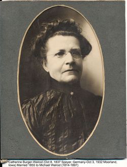
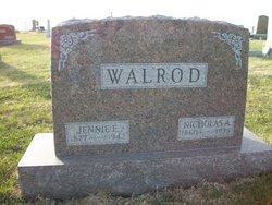
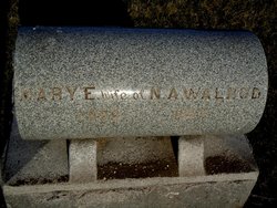
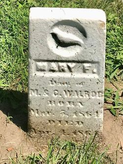
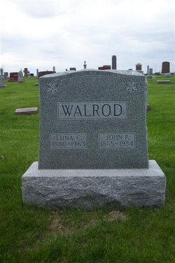
Nicholas Abraham Walrod
| Birth | : | 1860 |
| Death | : | 1935 |
| Burial | : | Mound Grove Cemetery, Independence, Jackson County, USA |
| Coordinate | : | 39.1128006, -94.4281006 |
| Description | : | Marion Clinton Davis (1850-1937) married Mary Elizabeth Mather (1858-1884) and from that union was born Edward H. (1876-1945) and William E. Davis(1878-1960). Shortly after William was born, Marion and Mary separated. Edward stayed with Marion and was raised by him and his parents on the home farm in Welton, IA, while William went with his mother and was raised by her parents, Cotton Smith and Mary Mather who recently moved (1881) from Clinton Co. to Calhoun Co., IA. William remained in that area until his death. He is buried in the Cedar cemetery. He farmed his entire life and raised a... Read More |
frequently asked questions (FAQ):
-
Where is Nicholas Abraham Walrod's memorial?
Nicholas Abraham Walrod's memorial is located at: Mound Grove Cemetery, Independence, Jackson County, USA.
-
When did Nicholas Abraham Walrod death?
Nicholas Abraham Walrod death on 1935 in
-
Where are the coordinates of the Nicholas Abraham Walrod's memorial?
Latitude: 39.1128006
Longitude: -94.4281006
Family Members:
Parent

Spouse
Siblings
Children
Flowers:


Nearby Cemetories:
1. Mound Grove Cemetery
Independence, Jackson County, USA
Coordinate: 39.1128006, -94.4281006
2. Harry S. Truman Library and Museum
Independence, Jackson County, USA
Coordinate: 39.1035200, -94.4213900
3. Trinity Episcopal Church Columbarium
Independence, Jackson County, USA
Coordinate: 39.0952300, -94.4166400
4. Long Cemetery
Independence, Jackson County, USA
Coordinate: 39.1284700, -94.4097700
5. Tucker Cemetery
Independence, Jackson County, USA
Coordinate: 39.1224300, -94.4021600
6. Reed Cemetery
Independence, Jackson County, USA
Coordinate: 39.1097400, -94.4593900
7. Hedrick Cemetery
Independence, Jackson County, USA
Coordinate: 39.1072006, -94.3914032
8. Woodlawn Cemetery
Independence, Jackson County, USA
Coordinate: 39.0856018, -94.4107971
9. Hill Park Cemetery
Independence, Jackson County, USA
Coordinate: 39.0835991, -94.4539032
10. Staples Family Cemetery
East Independence, Jackson County, USA
Coordinate: 39.1201400, -94.3797800
11. Smiley Cemetery
Sugar Creek, Jackson County, USA
Coordinate: 39.1411000, -94.3941900
12. Mount Washington Cemetery
Independence, Jackson County, USA
Coordinate: 39.0957985, -94.4757996
13. Mann Cemetery
Sugar Creek, Jackson County, USA
Coordinate: 39.1511002, -94.4002991
14. Lincoln Cemetery
Kansas City, Jackson County, USA
Coordinate: 39.0946999, -94.4805984
15. Kehilath Israel Blue Ridge Cemetery
Independence, Jackson County, USA
Coordinate: 39.0875015, -94.4766998
16. Highland Cemetery
Kansas City, Jackson County, USA
Coordinate: 39.0853004, -94.4760971
17. Blue Ridge Lawn Memorial Gardens
Kansas City, Jackson County, USA
Coordinate: 39.0760002, -94.4717026
18. Oak Ridge Memory Gardens
Independence, Jackson County, USA
Coordinate: 39.1046982, -94.3638992
19. Pitcher Cemetery
Independence, Jackson County, USA
Coordinate: 39.0635986, -94.4702988
20. Minneville Cemetery
Minaville, Clay County, USA
Coordinate: 39.1671906, -94.4616928
21. Sheffield Cemetery
Kansas City, Jackson County, USA
Coordinate: 39.1082993, -94.5083008
22. Webb Cemetery
Independence, Jackson County, USA
Coordinate: 39.1138600, -94.3403200
23. Lewis-Gregg Cemetery
Independence, Jackson County, USA
Coordinate: 39.1454700, -94.3467400
24. Luttrell Cemetery
Independence, Jackson County, USA
Coordinate: 39.0504700, -94.3839300