
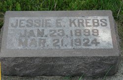
Jessie Eldora Krebs
| Birth | : | 23 Jan 1899 Neligh, Antelope County, Nebraska, USA |
| Death | : | 21 Mar 1924 Neligh, Antelope County, Nebraska, USA |
| Burial | : | Corbett Cemetery, Cleveland County, USA |
| Coordinate | : | 34.9756330, -97.2303600 |
| Plot | : | Section 2, Lot 180 |
frequently asked questions (FAQ):
-
Where is Jessie Eldora Krebs's memorial?
Jessie Eldora Krebs's memorial is located at: Corbett Cemetery, Cleveland County, USA.
-
When did Jessie Eldora Krebs death?
Jessie Eldora Krebs death on 21 Mar 1924 in Neligh, Antelope County, Nebraska, USA
-
Where are the coordinates of the Jessie Eldora Krebs's memorial?
Latitude: 34.9756330
Longitude: -97.2303600
Family Members:
Parent
Siblings

Flowers:


Nearby Cemetories:
1. Corbett Cemetery
Cleveland County, USA
Coordinate: 34.9756330, -97.2303600
2. Holsonbake Cemetery
Cleveland County, USA
Coordinate: 34.9707985, -97.2652969
3. Rose Cemetery
Lexington, Cleveland County, USA
Coordinate: 34.9947770, -97.1607283
4. Lexington Cemetery
Lexington, Cleveland County, USA
Coordinate: 35.0028000, -97.3005981
5. Mount Zion Cemetery
Lexington, Cleveland County, USA
Coordinate: 34.9564018, -97.1493988
6. Hopping Cemetery
Hopping Township, McClain County, USA
Coordinate: 34.9202500, -97.2839700
7. Box Cemetery
Cleveland County, USA
Coordinate: 34.9707985, -97.1417007
8. Saint Johns Cemetery
Lexington, Cleveland County, USA
Coordinate: 35.0106010, -97.3171997
9. Chappel Hill Cemetery
Cleveland County, USA
Coordinate: 35.0300950, -97.1596140
10. Rosedale Cemetery
Rosedale, McClain County, USA
Coordinate: 34.9063988, -97.1624985
11. Martin Hill Cemetery
Pottawatomie County, USA
Coordinate: 34.9996986, -97.1141968
12. Willow View Cemetery
Cleveland County, USA
Coordinate: 35.0653000, -97.2825012
13. Blue Branch Cemetery
Rosedale, McClain County, USA
Coordinate: 34.8841120, -97.1591230
14. Metcalf Cemetery Wilkerson
Wanette, Pottawatomie County, USA
Coordinate: 35.0581017, -97.1258011
15. Fort Family Cemetery
McClain County, USA
Coordinate: 34.8697014, -97.1596985
16. Hillside Cemetery
Purcell, McClain County, USA
Coordinate: 34.9967003, -97.3794022
17. Banner Cemetery
Cleveland County, USA
Coordinate: 35.1016998, -97.2564011
18. Saint Gregory Cemetery
Trousdale, Pottawatomie County, USA
Coordinate: 35.0172220, -97.0718800
19. Council Creek Cemetery
Pottawatomie County, USA
Coordinate: 35.0867004, -97.1250000
20. Red Oak Cemetery
Etowah, Cleveland County, USA
Coordinate: 35.1011009, -97.1505966
21. Shiloh Cemetery
Slaughterville, Cleveland County, USA
Coordinate: 35.0946650, -97.3354750
22. Dulin Family Cemetery
Garvin County, USA
Coordinate: 34.8275700, -97.2561700
23. Paoli Cemetery
Paoli, Garvin County, USA
Coordinate: 34.8231010, -97.2463989
24. Old Johnsonville Cemetery
Johnsonville, McClain County, USA
Coordinate: 34.8986893, -97.0475082