
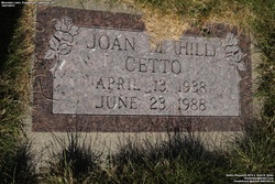


Joan Marlene Hill Cetto
| Birth | : | 13 Apr 1938 Deadwood, Lawrence County, South Dakota, USA |
| Death | : | 23 Jun 1988 Montana, USA |
| Burial | : | Mountain Lawn Cemetery, Englewood, Lawrence County, USA |
| Coordinate | : | 44.2818985, -103.8047028 |
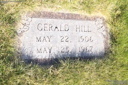
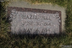
| Description | : | Joan Marlene was the daughter of Gerald and Hazel (Oines) Hill. She died of diabetes. Her father Gerald, was the son of Howard & Hallie (McKnelly) Hill. The death date for Joan is 15 June 1988 and she was buried on 23 June 1988. Joan died in Montana but was brought back to South Dakota to be buried. (Stramoski & Mataya Family Records) |
frequently asked questions (FAQ):
-
Where is Joan Marlene Hill Cetto's memorial?
Joan Marlene Hill Cetto's memorial is located at: Mountain Lawn Cemetery, Englewood, Lawrence County, USA.
-
When did Joan Marlene Hill Cetto death?
Joan Marlene Hill Cetto death on 23 Jun 1988 in Montana, USA
-
Where are the coordinates of the Joan Marlene Hill Cetto's memorial?
Latitude: 44.2818985
Longitude: -103.8047028
Family Members:
Parent
Flowers:


Nearby Cemetories:
1. Holy Cross Cemetery
Englewood, Lawrence County, USA
Coordinate: 44.2818985, -103.8047028
2. Mountain Lawn Cemetery
Englewood, Lawrence County, USA
Coordinate: 44.2818985, -103.8047028
3. Terry Cemetery
Terry, Lawrence County, USA
Coordinate: 44.3344290, -103.8165110
4. Dumont Cemetery
Lawrence County, USA
Coordinate: 44.2270000, -103.7860000
5. Carr Cemetery
Hanna, Lawrence County, USA
Coordinate: 44.2411003, -103.8606033
6. West Lead Cemetery
Lead, Lawrence County, USA
Coordinate: 44.3484001, -103.7779999
7. South Lead Cemetery
Lead, Lawrence County, USA
Coordinate: 44.3478510, -103.7606260
8. Preston Ghost Town Cemetery
Preston, Lawrence County, USA
Coordinate: 44.3577500, -103.8871670
9. Roubaix Cemetery
Roubaix, Lawrence County, USA
Coordinate: 44.2789380, -103.6656600
10. Mount Moriah Cemetery
Deadwood, Lawrence County, USA
Coordinate: 44.3760986, -103.7253036
11. Saint Ambrose Cemetery
Deadwood, Lawrence County, USA
Coordinate: 44.3821983, -103.7266998
12. Carbonate Cemetery
Maurice, Lawrence County, USA
Coordinate: 44.4000000, -103.8680500
13. Galena Cemetery
Galena, Lawrence County, USA
Coordinate: 44.3349220, -103.6438410
14. Mountain Meadow Cemetery
Lawrence County, USA
Coordinate: 44.2038994, -103.6557999
15. Oak Ridge Cemetery
Deadwood, Lawrence County, USA
Coordinate: 44.3891983, -103.6766968
16. Bell Park Cemetery
Rochford, Pennington County, USA
Coordinate: 44.1116982, -103.7466965
17. Bear Gulch Cemetery
Lawrence County, USA
Coordinate: 44.3819008, -104.0325012
18. Reynolds Ranch Cemetery
Rochford, Pennington County, USA
Coordinate: 44.0875667, -103.8027265
19. Rose Hill Cemetery
Spearfish, Lawrence County, USA
Coordinate: 44.4802180, -103.8509270
20. Crook City Cemetery
Crook City, Lawrence County, USA
Coordinate: 44.4432100, -103.6241500
21. Anderson Cemetery
Lawrence County, USA
Coordinate: 44.4747009, -103.6896973
22. Whitewood Cemetery
Whitewood, Lawrence County, USA
Coordinate: 44.4617820, -103.6330030
23. Nemo Cemetery
Nemo, Lawrence County, USA
Coordinate: 44.1872800, -103.5066410
24. Saint Aloysius Cemetery
Sturgis, Meade County, USA
Coordinate: 44.4141340, -103.5193420