
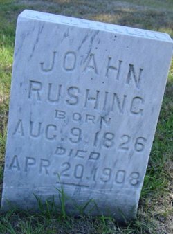
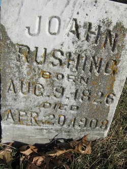
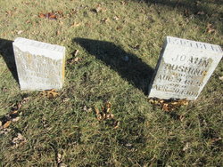
Joann Diana Ward Rushing
| Birth | : | 9 Aug 1826 Ohio, USA |
| Death | : | 20 Apr 1908 Osceola, Clarke County, Iowa, USA |
| Burial | : | Mount Vernon Cemetery, Peru, Nemaha County, USA |
| Coordinate | : | 40.4768982, -95.7208023 |
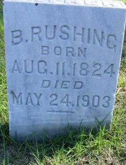
| Description | : | Joann Rushing Mrs. Joann Rushing died April 20, 1908, at the home of her son, William Rushing in South Osceola, after a long and painful illness. Joann Ward was born in Madison County, Ohio, Aug.9, 1827 and was at the time of her death, eighty-one years, eight months and four day old. She was unified in marriage to Bryant Rushing in Illinois June 8, 1844. To this union nine children were born, five boys and four girls; three died in infancy. The living are Mary C... Read More |
frequently asked questions (FAQ):
-
Where is Joann Diana Ward Rushing's memorial?
Joann Diana Ward Rushing's memorial is located at: Mount Vernon Cemetery, Peru, Nemaha County, USA.
-
When did Joann Diana Ward Rushing death?
Joann Diana Ward Rushing death on 20 Apr 1908 in Osceola, Clarke County, Iowa, USA
-
Where are the coordinates of the Joann Diana Ward Rushing's memorial?
Latitude: 40.4768982
Longitude: -95.7208023
Family Members:
Parent
Spouse
Siblings
Children
Flowers:


Nearby Cemetories:
1. Mount Vernon Cemetery
Peru, Nemaha County, USA
Coordinate: 40.4768982, -95.7208023
2. Honey Creek Cemetery
Nemaha Township, Nemaha County, USA
Coordinate: 40.4430199, -95.6980820
3. Sonora Cemetery
Watson, Atchison County, USA
Coordinate: 40.4730988, -95.6521988
4. Karn Cemetery
Glenrock, Nemaha County, USA
Coordinate: 40.4789000, -95.7917000
5. London Cemetery
Peru, Nemaha County, USA
Coordinate: 40.4225006, -95.7621994
6. Highland Methodist Cemetery
Nemaha County, USA
Coordinate: 40.4581850, -95.8097140
7. Highland Baptist Cemetery
Auburn, Nemaha County, USA
Coordinate: 40.4578018, -95.8191986
8. Walnut Grove Cemetery
Brownville, Nemaha County, USA
Coordinate: 40.4023056, -95.6642990
9. Kinser Burial Site
Watson, Atchison County, USA
Coordinate: 40.4974350, -95.5908610
10. Addington Cemetery
Watson, Atchison County, USA
Coordinate: 40.4721985, -95.5828018
11. Clayton-Lewis Cemetery
Rock Port, Atchison County, USA
Coordinate: 40.5439730, -95.6102280
12. Saint Bernards Church Cemetery
Julian, Nemaha County, USA
Coordinate: 40.5078000, -95.8592000
13. Camp Creek Cemetery
Otoe County, USA
Coordinate: 40.5681000, -95.8019028
14. Glenrock Cemetery
Glenrock, Nemaha County, USA
Coordinate: 40.4644012, -95.8764038
15. High Creek Cemetery
Rock Port, Atchison County, USA
Coordinate: 40.5086780, -95.5690380
16. Union Cemetery
Rock Port, Atchison County, USA
Coordinate: 40.5685000, -95.6110000
17. Stoner Cemetery
Atchison County, USA
Coordinate: 40.5127983, -95.5618973
18. Sheridan Cemetery
Auburn, Nemaha County, USA
Coordinate: 40.3936005, -95.8591995
19. Klaus Burial Site
Watson, Atchison County, USA
Coordinate: 40.4917400, -95.5440620
20. Nemaha Cemetery
Nemaha, Nemaha County, USA
Coordinate: 40.3469009, -95.6596985
21. Linden Cemetery
Watson, Atchison County, USA
Coordinate: 40.4856130, -95.5383220
22. Millsap Cemetery
Rock Port, Atchison County, USA
Coordinate: 40.4150009, -95.5532990
23. Sheridan West Memorial Cemetery
Auburn, Nemaha County, USA
Coordinate: 40.3920580, -95.8701320
24. Lansdown family burial site
Rock Port, Atchison County, USA
Coordinate: 40.4154319, -95.5522575