
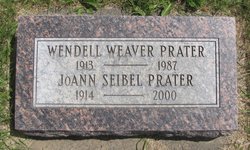
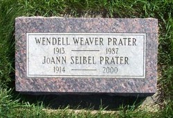
JoAnn Seibel Prater
| Birth | : | 3 Jan 1914 Pleasant Lake, Steuben County, Indiana, USA |
| Death | : | 24 Oct 2000 Yakima, Yakima County, Washington, USA |
| Burial | : | St. John the Baptist Churchyard, South Carlton, West Lindsey District, England |
| Coordinate | : | 53.2785000, -0.5754000 |
| Description | : | OBIT: JoAnn Elizabeth Seibel Prater, a long-time Kittitas Valley resident, died October 24, 2000, at the age of 86. She was born on January 3, 1914 in Pleasant Lake, Indiana. In 1918, JoAnn moved west by train to Ellensburg with her parents, Adolph and Gladys Seibel. The Seibel family settled in the Edgemont Thrall District where they developed and operated an apple orchard. JoAnn's father, Adolph (fondly known in the community as Si) also taught in the Ellensburg Public School System and at what was then Central Washington State Normal School. Her mother, Galdys, an artist and musician, taught, piano,... Read More |
frequently asked questions (FAQ):
-
Where is JoAnn Seibel Prater's memorial?
JoAnn Seibel Prater's memorial is located at: St. John the Baptist Churchyard, South Carlton, West Lindsey District, England.
-
When did JoAnn Seibel Prater death?
JoAnn Seibel Prater death on 24 Oct 2000 in Yakima, Yakima County, Washington, USA
-
Where are the coordinates of the JoAnn Seibel Prater's memorial?
Latitude: 53.2785000
Longitude: -0.5754000
Family Members:
Parent

Spouse
Flowers:


Nearby Cemetories:
1. St. John the Baptist Churchyard
South Carlton, West Lindsey District, England
Coordinate: 53.2785000, -0.5754000
2. St. Luke's Churchyard
North Carlton, West Lindsey District, England
Coordinate: 53.2873000, -0.5831200
3. St. Vincent Churchyard
Burton, West Lindsey District, England
Coordinate: 53.2596400, -0.5598100
4. St. John the Baptist Churchyard
Scampton, West Lindsey District, England
Coordinate: 53.3037680, -0.5787140
5. Dam Busters Dog Memorial
Scampton, West Lindsey District, England
Coordinate: 53.3008200, -0.5495800
6. St. Mary's Churchyard
Riseholme, West Lindsey District, England
Coordinate: 53.2688200, -0.5264900
7. St Peter's Churchyard
Aisthorpe, West Lindsey District, England
Coordinate: 53.3102400, -0.5815300
8. St Cuthbert's Churchyard
Brattleby, West Lindsey District, England
Coordinate: 53.3156600, -0.5794750
9. All Saints Churchyard
Broxholme, West Lindsey District, England
Coordinate: 53.2922400, -0.6349600
10. St Nicholas Parish Churchyard
Lincoln, City of Lincoln, England
Coordinate: 53.2400800, -0.5376400
11. Newport Cemetery
Lincoln, City of Lincoln, England
Coordinate: 53.2405150, -0.5362590
12. Saint Mary Magdalene in the Bail Churchyard
Lincoln, City of Lincoln, England
Coordinate: 53.2366000, -0.5402700
13. Lincoln Castle Cemetery
Lincoln, City of Lincoln, England
Coordinate: 53.2342640, -0.5415700
14. St. Michael's Churchyard
Cammeringham, West Lindsey District, England
Coordinate: 53.3275480, -0.5781450
15. Eastgate Cemetery
Lincoln, City of Lincoln, England
Coordinate: 53.2371410, -0.5312100
16. St. Peter in Eastgate Churchyard
Lincoln, City of Lincoln, England
Coordinate: 53.2355350, -0.5335080
17. Woodbank Cemetery
Skellingthorpe, North Kesteven District, England
Coordinate: 53.2375380, -0.6229660
18. Saxilby Cemetery
Saxilby, West Lindsey District, England
Coordinate: 53.2755800, -0.6590400
19. Lincoln Cathedral
Lincoln, City of Lincoln, England
Coordinate: 53.2341805, -0.5363450
20. St. Botolph Churchyard
Saxilby, West Lindsey District, England
Coordinate: 53.2747300, -0.6591000
21. St. Michael on the Mount Churchyard
Lincoln, City of Lincoln, England
Coordinate: 53.2334150, -0.5378640
22. Saint Margaret in the Close Churchyard
Lincoln, City of Lincoln, England
Coordinate: 53.2338310, -0.5352511
23. St. Martin's Churchyard
Lincoln, City of Lincoln, England
Coordinate: 53.2303499, -0.5425414
24. All Saints Churchyard
Nettleham, West Lindsey District, England
Coordinate: 53.2652940, -0.4906780