
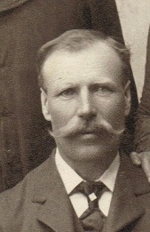

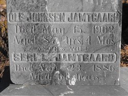
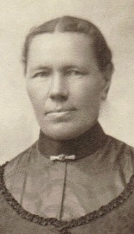
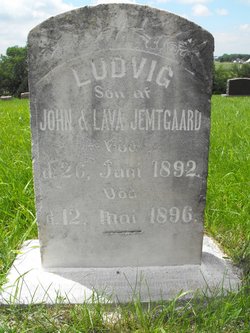
Johan Olson Jamtgaard
| Birth | : | 30 Jun 1849 Oksevik, Frøya kommune, Sør-Trøndelag fylke, Norway |
| Death | : | 29 Jul 1935 Union County, South Dakota, USA |
| Burial | : | North Embro Cemetery, Embro, Oxford County Municipality, Canada |
| Coordinate | : | 43.1667920, -80.9040350 |
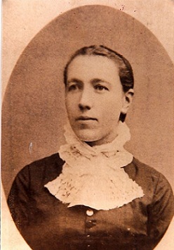
| Description | : | Johan Olsen Jamtgaard was born on 30 June 1849 at Orkedahlen, Sor Trondelag, Norway. He was the son of Ole Jamtgaard and Sigrid Lium. Johan Olsen Jamtgaard married Olava Quall, daughter of Lars Olsen Quall and Beret, in 1872 at Ishpeming, Michigan. Johan Olsen Jamtgaard died on 29 July 1935 at age 86. Johan Olsen Jamtgaard was a farmer. Johan Olsen Jamtgaard was also known as John. He immigrated on 10 June 1871 to Ishpeming, Michigan. He migrated in 1874 at 10 miles south of Alcester, Union, South Dakota. He was listed as the head of... Read More |
frequently asked questions (FAQ):
-
Where is Johan Olson Jamtgaard's memorial?
Johan Olson Jamtgaard's memorial is located at: North Embro Cemetery, Embro, Oxford County Municipality, Canada.
-
When did Johan Olson Jamtgaard death?
Johan Olson Jamtgaard death on 29 Jul 1935 in Union County, South Dakota, USA
-
Where are the coordinates of the Johan Olson Jamtgaard's memorial?
Latitude: 43.1667920
Longitude: -80.9040350
Family Members:
Parent

Spouse
Siblings

Children
Flowers:


Nearby Cemetories:
1. North Embro Cemetery
Embro, Oxford County Municipality, Canada
Coordinate: 43.1667920, -80.9040350
2. Methodist Cemetery
Embro, Oxford County Municipality, Canada
Coordinate: 43.1495018, -80.8983841
3. Old Log Church Cemetery
Embro, Oxford County Municipality, Canada
Coordinate: 43.1529121, -80.8626785
4. Scottish Pioneer
Holiday, Oxford County Municipality, Canada
Coordinate: 43.1334100, -80.9626100
5. Red Star Cemetery
Embro, Oxford County Municipality, Canada
Coordinate: 43.1124175, -80.9326897
6. Townline Methodist Church Cemetery
Zorra, Oxford County Municipality, Canada
Coordinate: 43.1842410, -80.9877280
7. Vandecar Cemetery
Vandecar, Oxford County Municipality, Canada
Coordinate: 43.2010640, -80.8148020
8. Oxford Memorial Park Cemetery
Woodstock, Oxford County Municipality, Canada
Coordinate: 43.1148200, -80.8150400
9. Huntingford Christ Church Anglican Cemetery
Huntingford, Oxford County Municipality, Canada
Coordinate: 43.2000280, -80.7960970
10. House of Refuge Cemetery
Woodstock, Oxford County Municipality, Canada
Coordinate: 43.1476245, -80.7873872
11. Lakeside Cemetery
Lakeside, Oxford County Municipality, Canada
Coordinate: 43.2035570, -81.0203780
12. Christ Church Anglican Cemetery
Lakeside, Oxford County Municipality, Canada
Coordinate: 43.2002540, -81.0231730
13. Beachville Cemetery
Beachville, Oxford County Municipality, Canada
Coordinate: 43.0889511, -80.8313599
14. Saint Marys Roman Catholic Cemetery
Woodstock, Oxford County Municipality, Canada
Coordinate: 43.1089400, -80.7998900
15. Broadview United Cemetery
Harrington, Oxford County Municipality, Canada
Coordinate: 43.2436256, -80.9847336
16. Knox Presbyterian Church Cemetery
Harrington, Oxford County Municipality, Canada
Coordinate: 43.2440758, -80.9855423
17. Kintore Methodist Cemetery
Kintore, Oxford County Municipality, Canada
Coordinate: 43.1373300, -81.0343700
18. Kintore Presbyterian Cemetery
Kintore, Oxford County Municipality, Canada
Coordinate: 43.1376900, -81.0349500
19. Anglican Cemetery
Woodstock, Oxford County Municipality, Canada
Coordinate: 43.1426000, -80.7653300
20. Woodstock Baptist Cemetery
Woodstock, Oxford County Municipality, Canada
Coordinate: 43.1416460, -80.7655790
21. Woodstock Presbyterian Cemetery
Woodstock, Oxford County Municipality, Canada
Coordinate: 43.1409440, -80.7651600
22. Hillview Cemetery
Woodstock, Oxford County Municipality, Canada
Coordinate: 43.1206703, -80.7675400
23. Ingersoll Rural Cemetery
Ingersoll, Oxford County Municipality, Canada
Coordinate: 43.0545040, -80.8732690
24. Sacred Heart Cemetery
Ingersoll, Oxford County Municipality, Canada
Coordinate: 43.0514300, -80.8917200