
| Birth | : | 6 Aug 1882 Union County, South Dakota, USA |
| Death | : | 1955 Union County, South Dakota, USA |
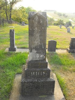
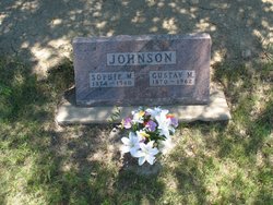
| Burial | : | Roseni Lutheran Church Cemetery, Beresford, Union County, USA |
| Coordinate | : | 42.9388000, -96.7639000 |
| Plot | : | Pt. 1 Lt. 83-------possible |
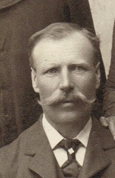
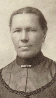
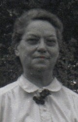
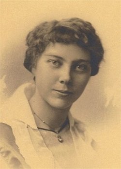
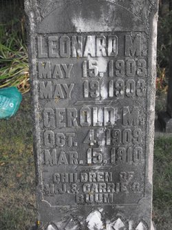
| Description | : | Carrie Jamtgaard was born on 6 August 1882 at South Dakota. She was the daughter of Johan Olsen Jamtgaard and Olava Quall. Carrie Jamtgaard married Martin J. Buum, son of John R. Buum Jr. and Gertrude Quall, on 15 October 1902. Carrie Jamtgaard died in 1955 at Union, South Dakota. Carrie Jamtgaard was also known as Karen (?). She was listed as a daughter in Johan Olsen Jamtgaard's household on the 1900 Census at Big Springs, Union, South Dakota.1 As of 15 October 1902,her married name was Buum. Carrie Jamtgaard had 5 with 3 living in... Read More |
frequently asked questions (FAQ):
-
Where is Carrie Jamtgaard Buum's memorial?
Carrie Jamtgaard Buum's memorial is located at: Roseni Lutheran Church Cemetery, Beresford, Union County, USA.
-
When did Carrie Jamtgaard Buum death?
Carrie Jamtgaard Buum death on 1955 in Union County, South Dakota, USA
-
Where are the coordinates of the Carrie Jamtgaard Buum's memorial?
Latitude: 42.9388000
Longitude: -96.7639000
Family Members:
Parent
Spouse
Siblings

Children

Flowers:


Nearby Cemetories:
1. Roseni Lutheran Church Cemetery
Beresford, Union County, USA
Coordinate: 42.9388000, -96.7639000
2. Olbue Lerseth Cemetery
Beresford, Union County, USA
Coordinate: 42.9281100, -96.7516100
3. Nora Cemetery
Union County, USA
Coordinate: 42.9314003, -96.7061005
4. Saint Joseph Catholic Church Cemetery
Emmet, Union County, USA
Coordinate: 42.9836950, -96.7466350
5. Rockfield Cemetery
Clay County, USA
Coordinate: 42.9397011, -96.8302994
6. Pleasant Hill Cemetery
Spink, Union County, USA
Coordinate: 42.8741000, -96.6876000
7. Pleasant Hill Cemetery Old
Spink, Union County, USA
Coordinate: 42.8588462, -96.7215592
8. Saint Mary Cemetery
Union County, USA
Coordinate: 42.8520584, -96.7877502
9. Dalesburg Baptist Cemetery
Dalesburg, Clay County, USA
Coordinate: 42.9675102, -96.8850403
10. Danefield Seventh Day Advent Cemetery
Clay County, USA
Coordinate: 43.0108000, -96.8452300
11. Peace Lutheran Cemetery
Union County, USA
Coordinate: 42.9805984, -96.6481018
12. Brule Creek Cemetery
Spink Township, Union County, USA
Coordinate: 42.8346510, -96.7324350
13. Saint Peter Greenfield Cemetery
Vermillion, Clay County, USA
Coordinate: 42.8608017, -96.8644028
14. Clay Point Cemetery
Prairie Center Township, Clay County, USA
Coordinate: 42.8987700, -96.9065600
15. Big Springs Cemetery
Big Springs, Union County, USA
Coordinate: 42.9379000, -96.6090000
16. Ahlsborg Lutheran Cemetery
Union County, USA
Coordinate: 42.8228000, -96.7612000
17. Dalesburg Lutheran Cemetery
Vermillion, Clay County, USA
Coordinate: 42.9389424, -96.9242594
18. Old Big Springs Cemetery
Big Springs, Union County, USA
Coordinate: 42.9455986, -96.5868988
19. Saint Peters Cemetery
Clay County, USA
Coordinate: 43.0619011, -96.8244019
20. Beresford Memorial Park Cemetery
Beresford, Union County, USA
Coordinate: 43.0695763, -96.7517853
21. Emmanuel Lutheran Cemetery
Beresford, Union County, USA
Coordinate: 43.0698280, -96.7529907
22. Saint Johns Cemetery
Beresford, Union County, USA
Coordinate: 43.0699997, -96.7549973
23. Beresford Cemetery
Beresford, Union County, USA
Coordinate: 43.0699997, -96.7533035
24. Pleasant Hill Cemetery
Alcester, Union County, USA
Coordinate: 43.0266991, -96.6192017