
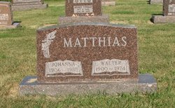
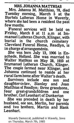
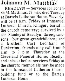
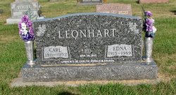
Johanna M Leonhart Matthias
| Birth | : | 12 Jul 1906 Netherlands |
| Death | : | 5 Mar 1985 Waverly, Bremer County, Iowa, USA |
| Burial | : | Greytown Cemetery, Greytown, South Wairarapa District, New Zealand |
| Coordinate | : | -41.0920470, 175.4401160 |
| Description | : | marriage: 28 May 1925 Klinger, Bremer, Iowa |
frequently asked questions (FAQ):
-
Where is Johanna M Leonhart Matthias's memorial?
Johanna M Leonhart Matthias's memorial is located at: Greytown Cemetery, Greytown, South Wairarapa District, New Zealand.
-
When did Johanna M Leonhart Matthias death?
Johanna M Leonhart Matthias death on 5 Mar 1985 in Waverly, Bremer County, Iowa, USA
-
Where are the coordinates of the Johanna M Leonhart Matthias's memorial?
Latitude: -41.0920470
Longitude: 175.4401160
Family Members:
Parent
Spouse

Siblings

Children
Flowers:


Nearby Cemetories:
1. Greytown Cemetery
Greytown, South Wairarapa District, New Zealand
Coordinate: -41.0920470, 175.4401160
2. Papawai Urupā
Greytown, South Wairarapa District, New Zealand
Coordinate: -41.0985090, 175.4892270
3. Te Uru o Tane Urupā
Greytown, South Wairarapa District, New Zealand
Coordinate: -41.0570790, 175.4947740
4. Featherston Soldiers Cemetery
Featherston, South Wairarapa District, New Zealand
Coordinate: -41.1212630, 175.3147170
5. Featherston Cemetery
Featherston, South Wairarapa District, New Zealand
Coordinate: -41.1217800, 175.3144160
6. Oates Family Cemetery
Carterton, Carterton District, New Zealand
Coordinate: -41.0453670, 175.5683580
7. Clareville Cemetery
Clareville, Carterton District, New Zealand
Coordinate: -40.9981070, 175.5459540
8. Waihenga Cemetery
Martinborough, South Wairarapa District, New Zealand
Coordinate: -41.2176230, 175.4528540
9. Martinborough Cemetery
Martinborough, South Wairarapa District, New Zealand
Coordinate: -41.2158720, 175.4722330
10. Hurunui-o-rangi
Masterton, Masterton District, New Zealand
Coordinate: -41.0709670, 175.6200720
11. Gladstone Church Cemetery
Gladstone, Carterton District, New Zealand
Coordinate: -41.0883600, 175.6432100
12. Pukio Cemetery
Kahutara, South Wairarapa District, New Zealand
Coordinate: -41.2460220, 175.3603000
13. Waipopo Urupā
Masterton, Masterton District, New Zealand
Coordinate: -41.0696370, 175.6604430
14. Waipoapoa Urupa
Hastings, Hastings District, New Zealand
Coordinate: -41.0696050, 175.6604650
15. Hamuera Urupā
Masterton District, New Zealand
Coordinate: -41.0374980, 175.6611940
16. Akura Urupā
Masterton, Masterton District, New Zealand
Coordinate: -40.9314120, 175.6349090
17. Riverside Cemetery
Masterton, Masterton District, New Zealand
Coordinate: -40.9621550, 175.6722690
18. Archer Street Cemetery
Masterton, Masterton District, New Zealand
Coordinate: -40.9538900, 175.6683800
19. Masterton War Memorial
Masterton, Masterton District, New Zealand
Coordinate: -40.9501290, 175.6648800
20. Ahi pane pane Urupā
Masterton, Masterton District, New Zealand
Coordinate: -40.9524060, 175.6902370
21. Te Ahitainga Urupā
Masterton, Masterton District, New Zealand
Coordinate: -40.9393000, 175.7030750
22. Akatarawa Cemetery
Upper Hutt City, New Zealand
Coordinate: -41.0876320, 175.1025870
23. Waiorongomai Cemetery
South Wairarapa District, New Zealand
Coordinate: -41.2535785, 175.1567108
24. Wallaceville Cemetery
Wallaceville, Upper Hutt City, New Zealand
Coordinate: -41.1359900, 175.0743300