
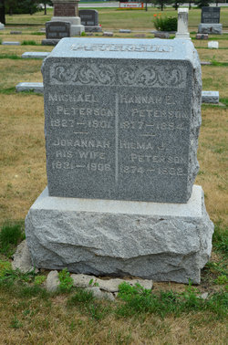
Johanna Maria Petersdotter Peterson
| Birth | : | 5 Feb 1831 Alseda, Vetlanda kommun, Jönköpings län, Sweden |
| Death | : | 22 Feb 1906 Kansas City, Jackson County, Missouri, USA |
| Burial | : | Dayton Cemetery, Dayton, Webster County, USA |
| Coordinate | : | 42.2675000, -94.0755000 |
| Description | : | Dayton Review March 8, 1906 OBITUARY Johanna Maria Peterson was born in Alseda, Jönköpings Län, Sweden, February 5, 1831. She grew to womanhood in her native land, where she was united in marriage to Michael Peterson, who preceded her to that better land some five years ago. In 1865 she came with her family to this country, settling in Illinois, and four years later came to this vicinity, where she lived until going to the home of her daughter in Kansas City, where she passed this life February 22, 1906, aged 75 years, 17 days. Her remains were... Read More |
frequently asked questions (FAQ):
-
Where is Johanna Maria Petersdotter Peterson's memorial?
Johanna Maria Petersdotter Peterson's memorial is located at: Dayton Cemetery, Dayton, Webster County, USA.
-
When did Johanna Maria Petersdotter Peterson death?
Johanna Maria Petersdotter Peterson death on 22 Feb 1906 in Kansas City, Jackson County, Missouri, USA
-
Where are the coordinates of the Johanna Maria Petersdotter Peterson's memorial?
Latitude: 42.2675000
Longitude: -94.0755000
Family Members:
Spouse

Children


Flowers:


Nearby Cemetories:
1. Dayton Cemetery
Dayton, Webster County, USA
Coordinate: 42.2675000, -94.0755000
2. Christ the King Catholic Cemetery
Dayton, Webster County, USA
Coordinate: 42.2601929, -94.0727539
3. Bass Cemetery
Dayton, Webster County, USA
Coordinate: 42.2966995, -94.0149994
4. Swedish Lutheran Church Cemetery
Dayton, Webster County, USA
Coordinate: 42.2175000, -94.1065000
5. Oak Grove Cemetery
Lehigh, Webster County, USA
Coordinate: 42.3438988, -94.0475006
6. Hardin Township Cemetery
Hardin Township, Webster County, USA
Coordinate: 42.2411003, -93.9708023
7. Linn Cemetery
Pilot Mound, Boone County, USA
Coordinate: 42.2045330, -93.9970230
8. Lawn Cemetery
Boone County, USA
Coordinate: 42.1771011, -94.0867996
9. West Lawn Cemetery
Lehigh, Webster County, USA
Coordinate: 42.3616982, -94.0678024
10. McGuire Bend Cemetery
Dayton, Webster County, USA
Coordinate: 42.3410000, -93.9880000
11. Runyan Cemetery
Pilot Mound, Boone County, USA
Coordinate: 42.1749992, -94.0015030
12. Pilot Mound Cemetery
Pilot Mound, Boone County, USA
Coordinate: 42.1636200, -94.0282600
13. Vegors Cemetery
Webster County, USA
Coordinate: 42.3177986, -93.9421997
14. Lost Grove Cemetery
Harcourt, Webster County, USA
Coordinate: 42.2583008, -94.2331009
15. Hooks Point Cemetery
Hamilton County, USA
Coordinate: 42.2944530, -93.9199090
16. Oakwood Cemetery
Stratford, Hamilton County, USA
Coordinate: 42.2942009, -93.9182968
17. Hartman Cemetery
Lehigh, Webster County, USA
Coordinate: 42.3666397, -93.9835627
18. White Cemetery
Boone County, USA
Coordinate: 42.1777992, -93.9636002
19. Border Plains Cemetery
Border Plains, Webster County, USA
Coordinate: 42.3917000, -94.0448000
20. Ober and Scott Cemetery
Duncombe, Webster County, USA
Coordinate: 42.3841390, -93.9982856
21. Union Cemetery
Boxholm, Boone County, USA
Coordinate: 42.1369019, -94.0852966
22. Renner Cemetery
Boone County, USA
Coordinate: 42.1380420, -94.1256570
23. Otho Cemetery
Otho, Webster County, USA
Coordinate: 42.4025002, -94.1153030
24. Schlicht Cemetery
Fraser, Boone County, USA
Coordinate: 42.1444200, -93.9780100