
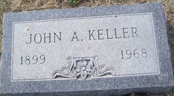
John A Keller
| Birth | : | 8 May 1899 Ellis County, Kansas, USA |
| Death | : | 1 Jun 1968 |
| Burial | : | Lima Union Cemetery, Lima, Grant County, USA |
| Coordinate | : | 42.8270000, -90.5266000 |
frequently asked questions (FAQ):
-
Where is John A Keller's memorial?
John A Keller's memorial is located at: Lima Union Cemetery, Lima, Grant County, USA.
-
When did John A Keller death?
John A Keller death on 1 Jun 1968 in
-
Where are the coordinates of the John A Keller's memorial?
Latitude: 42.8270000
Longitude: -90.5266000
Family Members:
Parent


Spouse
Siblings
Children

Flowers:


Nearby Cemetories:
1. Lima Union Cemetery
Lima, Grant County, USA
Coordinate: 42.8270000, -90.5266000
2. Willow Branch Mennonite Cemetery
Lancaster, Grant County, USA
Coordinate: 42.7986250, -90.5414980
3. Oak Ridge Cemetery
Union, Grant County, USA
Coordinate: 42.8386002, -90.5653000
4. Buck Wheat Ridge Cemetery
Ellenboro, Grant County, USA
Coordinate: 42.8199997, -90.5708008
5. Farview-Hake Cemetery
Union, Grant County, USA
Coordinate: 42.8638000, -90.5468400
6. Churchill Family Cemetery
Platteville, Grant County, USA
Coordinate: 42.7911677, -90.5005626
7. Arthur United Methodist Church Cemetery
Arthur, Grant County, USA
Coordinate: 42.8475860, -90.4454080
8. Nip and Tuck Cemetery
Arthur, Grant County, USA
Coordinate: 42.8283005, -90.4375000
9. McReynolds Cemetery
Arthur, Grant County, USA
Coordinate: 42.8246994, -90.4368973
10. Whig Cemetery
Platteville, Grant County, USA
Coordinate: 42.7611008, -90.5539017
11. Kirkpatrick Cemetery
Rewey, Iowa County, USA
Coordinate: 42.8244019, -90.4266968
12. Barnett Cemetery
Ellenboro, Grant County, USA
Coordinate: 42.7834972, -90.6120017
13. Barber Rhea Cemetery
Belmont, Lafayette County, USA
Coordinate: 42.8064700, -90.4187100
14. Ebenezer Cemetery
Mifflin, Iowa County, USA
Coordinate: 42.8703400, -90.4260200
15. Rock Church Cemetery
Livingston, Grant County, USA
Coordinate: 42.9043999, -90.4677963
16. Indian Park
Platteville, Grant County, USA
Coordinate: 42.7391700, -90.4768100
17. Aupperle Cemetery
Lancaster, Grant County, USA
Coordinate: 42.8130900, -90.6595900
18. Greenwood Cemetery
Platteville, Grant County, USA
Coordinate: 42.7313995, -90.4925003
19. Kaump Cemetery
Platteville, Grant County, USA
Coordinate: 42.7257996, -90.5622025
20. Hillside Cemetery
Platteville, Grant County, USA
Coordinate: 42.7257996, -90.4730988
21. Calvary Cemetery
Platteville, Grant County, USA
Coordinate: 42.7256012, -90.4710999
22. Harrison Cemetery
Platteville, Grant County, USA
Coordinate: 42.7257996, -90.5830994
23. Saint Pauls United Church of Christ Cemetery
Lancaster, Grant County, USA
Coordinate: 42.8890500, -90.6607270
24. Baily and McKinney Cemetery
Lancaster, Grant County, USA
Coordinate: 42.7891800, -90.6765100