
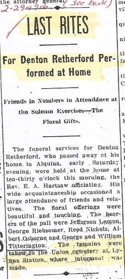
| Birth | : | 17 May 1833 Fayette County, Indiana, USA |
| Death | : | 12 Feb 1918 Windfall, Tipton County, Indiana, USA |
| Burial | : | Seventh-Day Baptists Settlement Cemetery, Watson, Lewis County, USA |
| Coordinate | : | 43.8108330, -75.3883330 |
| Plot | : | Block 3&4, Section F, Row 9 |
frequently asked questions (FAQ):
-
Where is John A Retherford's memorial?
John A Retherford's memorial is located at: Seventh-Day Baptists Settlement Cemetery, Watson, Lewis County, USA.
-
When did John A Retherford death?
John A Retherford death on 12 Feb 1918 in Windfall, Tipton County, Indiana, USA
-
Where are the coordinates of the John A Retherford's memorial?
Latitude: 43.8108330
Longitude: -75.3883330
Family Members:
Parent
Spouse

Siblings
Children
Flowers:


Nearby Cemetories:
1. Seventh-Day Baptists Settlement Cemetery
Watson, Lewis County, USA
Coordinate: 43.8108330, -75.3883330
2. Petries Corners Cemetery
Petries Corners, Lewis County, USA
Coordinate: 43.8037100, -75.3626600
3. Wetmore Cemetery
Lewis County, USA
Coordinate: 43.8008003, -75.3544006
4. Campville Cemetery
Watson, Lewis County, USA
Coordinate: 43.8008400, -75.3541500
5. Saint Peters Catholic Cemetery
New Bremen, Lewis County, USA
Coordinate: 43.8388000, -75.4220900
6. First Mennonite Church Cemetery
New Bremen, Lewis County, USA
Coordinate: 43.8398460, -75.4262460
7. Crystal Light Mennonite Church Cemetery
New Bremen, Lewis County, USA
Coordinate: 43.8358530, -75.4416550
8. Beaches Bridge Cemetery
Watson, Lewis County, USA
Coordinate: 43.7769012, -75.4317017
9. New Bremen Rural Cemetery
New Bremen, Lewis County, USA
Coordinate: 43.8376100, -75.4422400
10. Hope Mennonite Cemetery
Watson, Lewis County, USA
Coordinate: 43.7750280, -75.4314270
11. Spafford's Landing Cemetery
Lowville, Lewis County, USA
Coordinate: 43.7748460, -75.4496560
12. Croghan Apostolic Christian Cemetery
Croghan, Lewis County, USA
Coordinate: 43.8688090, -75.3914670
13. Sperryville Cemetery
Sperryville, Lewis County, USA
Coordinate: 43.7731600, -75.3103900
14. Old Landing Burial Ground
Lowville, Lewis County, USA
Coordinate: 43.7651600, -75.4614300
15. East Martinsburg Cemetery
East Martinsburg, Lewis County, USA
Coordinate: 43.7460700, -75.4256500
16. East Road Cemetery
Lowville, Lewis County, USA
Coordinate: 43.7872400, -75.4805200
17. Ebblie Cemetery
Lowville, Lewis County, USA
Coordinate: 43.8078003, -75.4897003
18. Old Quaker Cemetery
Lowville, Lewis County, USA
Coordinate: 43.7828700, -75.4824000
19. Jackson Street Cemetery
Lowville, Lewis County, USA
Coordinate: 43.7828400, -75.4863300
20. Riverside Cemetery
Beaver Falls, Lewis County, USA
Coordinate: 43.8854170, -75.4271670
21. Basselin Cemetery
Croghan, Lewis County, USA
Coordinate: 43.8944016, -75.3921967
22. Beaver Falls New Cemetery
Beaver Falls, Lewis County, USA
Coordinate: 43.8871390, -75.4400280
23. Lowville Rural Cemetery
Lowville, Lewis County, USA
Coordinate: 43.7824200, -75.5004100
24. Lewis County Home Cemetery
Lowville, Lewis County, USA
Coordinate: 43.7812300, -75.5001200