

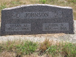
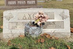
John Almond Johnson
| Birth | : | 12 Jun 1858 Berlin Township, Bureau County, Illinois, USA |
| Death | : | 13 Feb 1945 Long Beach, Los Angeles County, California, USA |
| Burial | : | Six Mile Grove Cemetery, Lyle, Mower County, USA |
| Coordinate | : | 43.5069389, -92.8836136 |
| Description | : | John, later moved to California, where he prospered as a merchant. He died 13 Feb 1945 in Long Beach, CA. |
frequently asked questions (FAQ):
-
Where is John Almond Johnson's memorial?
John Almond Johnson's memorial is located at: Six Mile Grove Cemetery, Lyle, Mower County, USA.
-
When did John Almond Johnson death?
John Almond Johnson death on 13 Feb 1945 in Long Beach, Los Angeles County, California, USA
-
Where are the coordinates of the John Almond Johnson's memorial?
Latitude: 43.5069389
Longitude: -92.8836136
Family Members:
Parent

Spouse
Siblings

Children
Flowers:


Nearby Cemetories:
1. Mona Cemetery
Mona, Mitchell County, USA
Coordinate: 43.4824982, -92.9402771
2. Pleasant Hill Cemetery
Mona, Mitchell County, USA
Coordinate: 43.4768982, -92.9467010
3. Union Township Cemetery
Toeterville, Mitchell County, USA
Coordinate: 43.4578018, -92.8491974
4. Union Presbyterian Cemetery
Stacyville, Mitchell County, USA
Coordinate: 43.4797211, -92.8088913
5. Rustad Cemetery
Otranto, Mitchell County, USA
Coordinate: 43.4585991, -92.9400024
6. Saint Peter Cemetery
Toeterville, Mitchell County, USA
Coordinate: 43.4402809, -92.8897171
7. Saint Johns Cemetery
Johnsburg, Mower County, USA
Coordinate: 43.5055618, -92.7688904
8. Woodbury Cemetery
Lyle, Mower County, USA
Coordinate: 43.5071983, -93.0083008
9. Ogden Cemetery
Otranto, Mitchell County, USA
Coordinate: 43.4366989, -92.9681015
10. Visitation Catholic Cemetery
Stacyville, Mitchell County, USA
Coordinate: 43.4430618, -92.7813873
11. Saint Peters Cemetery
Rose Creek, Mower County, USA
Coordinate: 43.6019402, -92.8375015
12. Stacyville Cemetery
Stacyville, Mitchell County, USA
Coordinate: 43.4294014, -92.7908020
13. Prairie View Cemetery
Rose Creek, Mower County, USA
Coordinate: 43.6085815, -92.8261871
14. Little Cedar Cemetery
Adams, Mower County, USA
Coordinate: 43.5736008, -92.7574997
15. Rose Creek Cemetery
Varco, Mower County, USA
Coordinate: 43.6164017, -92.9452972
16. McKinley Cemetery
Saint Ansgar, Mitchell County, USA
Coordinate: 43.3906400, -92.9368300
17. Cedar City Cemetery
Austin, Mower County, USA
Coordinate: 43.5872100, -93.0132500
18. First Lutheran Cemetery
Saint Ansgar, Mitchell County, USA
Coordinate: 43.3841705, -92.9194412
19. Deer Creek Lutheran Church Cemetery
Carpenter, Mitchell County, USA
Coordinate: 43.4297218, -93.0236130
20. Newburg Cemetery
Carpenter, Mitchell County, USA
Coordinate: 43.4143982, -93.0049973
21. Sacred Heart Cemetery
Adams, Mower County, USA
Coordinate: 43.5635986, -92.7221985
22. Saint Ansgar Cemetery
Saint Ansgar, Mitchell County, USA
Coordinate: 43.3777809, -92.9094391
23. Grandview Cemetery
Austin, Mower County, USA
Coordinate: 43.6333008, -92.9505997
24. Priem Cemetery
Carpenter, Mitchell County, USA
Coordinate: 43.3869019, -92.9747009