
John Amsden III
| Birth | : | 16 Feb 1721 Deerfield, Franklin County, Massachusetts, USA |
| Death | : | 10 Oct 1794 Deerfield, Franklin County, Massachusetts, USA |
| Burial | : | Mogollon Cemetery, Catron County, USA |
| Coordinate | : | 33.4061012, -108.7913971 |
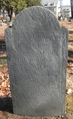
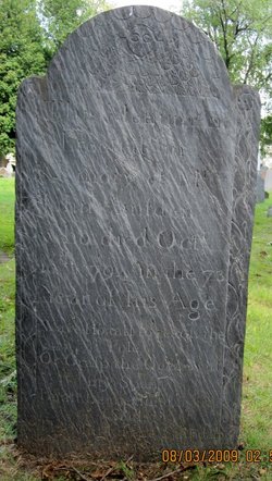
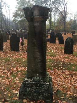
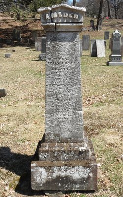
| Inscription | : | "This Monument/ is erected in the/ memory of Mr./ John Amsden/ who died Oct./ 10, 1794 in the 73d/ year of his age. Were I so tall to reach the Pole Or Grasp the Ocean with my Span I must be measured by m |
| Description | : | Cenotaph here. John Amsden, son of John Amsden and Mary Cowles, was married to Lydia Field. |
frequently asked questions (FAQ):
-
Where is John Amsden III's memorial?
John Amsden III's memorial is located at: Mogollon Cemetery, Catron County, USA.
-
When did John Amsden III death?
John Amsden III death on 10 Oct 1794 in Deerfield, Franklin County, Massachusetts, USA
-
Where are the coordinates of the John Amsden III's memorial?
Latitude: 33.4061012
Longitude: -108.7913971
Family Members:
Parent
Spouse
Siblings


Children
Flowers:


Nearby Cemetories:
1. Cooney Cemetery
Cooney, Catron County, USA
Coordinate: 33.4127998, -108.8368988
2. Alma Cemetery
Alma, Catron County, USA
Coordinate: 33.3803480, -108.9013210
3. Boot Hill Cemetery
Alma, Catron County, USA
Coordinate: 33.4005390, -108.9076770
4. Glenwood Cemetery
Glenwood, Catron County, USA
Coordinate: 33.3090235, -108.8911499
5. Pleasanton Cemetery
Pleasanton, Catron County, USA
Coordinate: 33.2761620, -108.8737890
6. Saint Isidoro Cemetery
Catron County, USA
Coordinate: 33.6590610, -108.7914400
7. Lower Frisco Catholic Cemetery
Reserve, Catron County, USA
Coordinate: 33.6633890, -108.7873080
8. Saint Francis Cemetery
Reserve, Catron County, USA
Coordinate: 33.6941660, -108.7676760
9. Jackson Ranch Cemetery
Buckhorn, Grant County, USA
Coordinate: 33.1070000, -108.7886000
10. Seventh Day Adventist Cemetery
Reserve, Catron County, USA
Coordinate: 33.7045140, -108.7596550
11. Papineau Grave
Catron County, USA
Coordinate: 33.3511009, -108.4332962
12. Reserve Cemetery
Reserve, Catron County, USA
Coordinate: 33.7131004, -108.7572021
13. Mule Creek Cemetery
Mule Creek, Grant County, USA
Coordinate: 33.1208530, -108.9548000
14. Blue River Gravesites
Blue, Greenlee County, USA
Coordinate: 33.6113290, -109.1078030
15. Jones Cemetery
Greenlee County, USA
Coordinate: 33.6006012, -109.1213989
16. Lanphier Ranch Cemetery
Blue, Greenlee County, USA
Coordinate: 33.5951220, -109.1303390
17. Fritz Gravesite
Greenlee County, USA
Coordinate: 33.3227580, -109.1908510
18. Blue Cemetery
Greenlee County, USA
Coordinate: 33.6488120, -109.0944860
19. Apache Creek Cemetery
Apache Creek, Catron County, USA
Coordinate: 33.8231812, -108.6480942
20. Dinwiddie Cemetery
Cliff, Grant County, USA
Coordinate: 32.9849740, -108.6500240
21. Luna Cemetery
Luna, Catron County, USA
Coordinate: 33.8233000, -108.9500000
22. Maldonado Cemetery
Grant County, USA
Coordinate: 33.0050011, -108.5453033
23. Stout Cemetery
Cliff, Grant County, USA
Coordinate: 32.9682999, -108.6258011
24. Mesa Cemetery
Gila, Grant County, USA
Coordinate: 32.9489500, -108.5872100