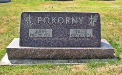
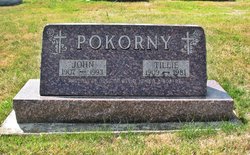
| Birth | : | 7 Mar 1940 Clutier, Tama County, Iowa, USA |
| Death | : | 19 May 2014 Waterloo, Black Hawk County, Iowa, USA |
| Burial | : | Saint Wenceslaus Cemetery, Clutier, Tama County, USA |
| Coordinate | : | 42.0870000, -92.4460000 |
| Description | : | John Anthony Pokorny, 74, of Clutier, died Monday, May 19, 2014 at Covenant Medical Center of natural causes. He was born March 7, 1940 in Clutier the son of John M. and Tillie Chizek Pokorny. He was a 1958 graduate of Clutier High School. He married Linda Cross on September 2, 1961 at the Immaculate Conception Church in Clutier; she preceded him in death in October of 1992. He farmed , was a Meat Cutter at Eagle's in Marshalltown, worked at Swift Packing, Van's Locker in Dysart and Wieck Brother's Oil Company. He was a member of St. Paul Catholic Church, Bohemian... Read More |
frequently asked questions (FAQ):
-
Where is John Anthony Pokorny's memorial?
John Anthony Pokorny's memorial is located at: Saint Wenceslaus Cemetery, Clutier, Tama County, USA.
-
When did John Anthony Pokorny death?
John Anthony Pokorny death on 19 May 2014 in Waterloo, Black Hawk County, Iowa, USA
-
Where are the coordinates of the John Anthony Pokorny's memorial?
Latitude: 42.0870000
Longitude: -92.4460000
Family Members:
Parent
Spouse
Siblings
Flowers:
Nearby Cemetories:
1. Saint Wenceslaus Cemetery
Clutier, Tama County, USA
Coordinate: 42.0870000, -92.4460000
2. Oneida Cemetery
Clutier, Tama County, USA
Coordinate: 42.1007996, -92.3966980
3. Clutier Cemetery
Clutier, Tama County, USA
Coordinate: 42.0792007, -92.3858032
4. Fee Chapel Cemetery
Tama County, USA
Coordinate: 42.0643997, -92.5117035
5. Holy Trinity Cemetery
Vining, Tama County, USA
Coordinate: 42.0293999, -92.4222031
6. Bakers Grove Cemetery
Traer, Tama County, USA
Coordinate: 42.1319008, -92.5143967
7. Roadside Cemetery
Clutier, Tama County, USA
Coordinate: 42.0574800, -92.3548800
8. Pleasant Hill Cemetery
Toledo, Tama County, USA
Coordinate: 42.1080000, -92.5595000
9. West Union Cemetery
Traer, Tama County, USA
Coordinate: 42.1817017, -92.4449997
10. Saint Pauls Catholic Cemetery
Traer, Tama County, USA
Coordinate: 42.1832000, -92.4688000
11. Waltham Cemetery
Elberon, Tama County, USA
Coordinate: 42.0355988, -92.3328018
12. Tama County Home Cemetery
Gladbrook, Tama County, USA
Coordinate: 42.0358241, -92.5626930
13. Lone Pine Cemetery
Tama County, USA
Coordinate: 42.0797005, -92.3082962
14. Hayes Cemetery
Toledo, Tama County, USA
Coordinate: 41.9789009, -92.4730988
15. Stayskal Cemetery
Vining, Tama County, USA
Coordinate: 41.9788000, -92.4080000
16. Rose Hill Cemetery
Toledo, Tama County, USA
Coordinate: 42.0505000, -92.5930000
17. Saint Marys Cemetery
Vining, Tama County, USA
Coordinate: 41.9906000, -92.3556000
18. Dysart Cemetery
Dysart, Tama County, USA
Coordinate: 42.1608009, -92.3193970
19. Buckingham Cemetery
Traer, Tama County, USA
Coordinate: 42.2069016, -92.4741974
20. Houghton Cemetery
Benton County, USA
Coordinate: 42.1088982, -92.2794037
21. Twogood Cemetery
Benton County, USA
Coordinate: 42.0499992, -92.2799988
22. National Cemetery
Vining, Tama County, USA
Coordinate: 41.9702988, -92.3705978
23. Woodlawn Cemetery
Toledo, Tama County, USA
Coordinate: 41.9866982, -92.5699997
24. Saint Josephs Catholic Cemetery
Benton County, USA
Coordinate: 42.1719017, -92.2981033


