
| Birth | : | 3 Dec 1840 Butler County, Ohio, USA |
| Death | : | 23 Feb 1912 Larned, Pawnee County, Kansas, USA |
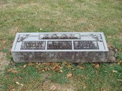
| Burial | : | Pleasant Valley Cemetery, Larned, Pawnee County, USA |
| Coordinate | : | 38.0718994, -99.0955963 |
frequently asked questions (FAQ):
-
Where is John B Zook's memorial?
John B Zook's memorial is located at: Pleasant Valley Cemetery, Larned, Pawnee County, USA.
-
When did John B Zook death?
John B Zook death on 23 Feb 1912 in Larned, Pawnee County, Kansas, USA
-
Where are the coordinates of the John B Zook's memorial?
Latitude: 38.0718994
Longitude: -99.0955963
Family Members:
Parent
Spouse

Siblings
Children
Flowers:


Nearby Cemetories:
1. Pleasant Valley Cemetery
Larned, Pawnee County, USA
Coordinate: 38.0718994, -99.0955963
2. Larned State Hospital Cemetery
Larned, Pawnee County, USA
Coordinate: 38.1722800, -99.1566200
3. Larned Cemetery
Larned, Pawnee County, USA
Coordinate: 38.1861000, -99.1333008
4. Belpre Cemetery
Belpre, Edwards County, USA
Coordinate: 37.9528950, -99.1017510
5. Garfield Cemetery
Garfield, Pawnee County, USA
Coordinate: 38.0738983, -99.2667007
6. Fertig Cemetery
Pawnee County, USA
Coordinate: 38.1458015, -98.9492035
7. Fort Larned Cemetery
Larned, Pawnee County, USA
Coordinate: 38.1839100, -99.2163200
8. Wayne Cemetery
Lewis, Edwards County, USA
Coordinate: 37.9550018, -99.2144012
9. Point View Cemetery
Pawnee County, USA
Coordinate: 38.1306000, -98.9131012
10. Farmington Cemetery
Macksville, Stafford County, USA
Coordinate: 37.9574510, -98.9608270
11. Township Cemetery
Macksville, Stafford County, USA
Coordinate: 37.9569016, -98.9582977
12. Fitch Family Cemetery
Nettleton, Edwards County, USA
Coordinate: 38.0007540, -99.3256550
13. Pawnee Rock State Historic Site
Pawnee Rock, Barton County, USA
Coordinate: 38.2721800, -98.9815300
14. Pawnee Rock Cemetery
Pawnee Rock, Barton County, USA
Coordinate: 38.2771988, -98.9858017
15. Ash Valley Cemetery
Pawnee County, USA
Coordinate: 38.2905998, -99.2174988
16. Devore Family Cemetery
St. John, Stafford County, USA
Coordinate: 38.0141200, -98.7947700
17. Pleasant Ridge Cemetery
Radium, Stafford County, USA
Coordinate: 38.2475014, -98.8758011
18. Peace Lutheran Cemetery
Kinsley, Edwards County, USA
Coordinate: 38.0285988, -99.4047012
19. Neelands Cemetery
St. John, Stafford County, USA
Coordinate: 37.9000015, -98.8660965
20. Bergthal Mennonite Cemetery
Pawnee Rock, Barton County, USA
Coordinate: 38.3053017, -98.9772034
21. Prattsburg Cemetery
Macksville, Stafford County, USA
Coordinate: 37.8283005, -99.0044022
22. Saint Francis Xavier Cemetery
Seward, Stafford County, USA
Coordinate: 38.2038994, -98.8193970
23. Fellsburg Cemetery
Edwards County, USA
Coordinate: 37.8069000, -99.1688995
24. Trotter Cemetery
Lewis, Edwards County, USA
Coordinate: 37.8394012, -99.2780991