
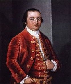
John Banister Famous memorial
| Birth | : | 26 Dec 1734 Petersburg, Petersburg City, Virginia, USA |
| Death | : | 30 Sep 1788 Petersburg, Petersburg City, Virginia, USA |
| Burial | : | St. Joseph Roman Catholic Churchyard, Hurst Green, Ribble Valley Borough, England |
| Coordinate | : | 53.8409900, -2.4820600 |
| Description | : | Continental Congressman. (in 1778) Signer and framer of the Articles of Confederation. Delegate from Virginia. John attended a private school located in Wakefield, England. He graduated in law from the Temple in London. He practiced law in Petersburg, Virginia upon his return to the Colonies. John was a member of the Virginia House of Burgesses in 1765-1775, and a member of the conventions of 1775 and 1776. He served in the Virginia house of delegates in 1776, 1777, and 1781-1783; During the Revolutionary War, John served as major and lieutenant colonel of the Virginia Militia. He died on... Read More |
frequently asked questions (FAQ):
-
Where is John Banister Famous memorial's memorial?
John Banister Famous memorial's memorial is located at: St. Joseph Roman Catholic Churchyard, Hurst Green, Ribble Valley Borough, England.
-
When did John Banister Famous memorial death?
John Banister Famous memorial death on 30 Sep 1788 in Petersburg, Petersburg City, Virginia, USA
-
Where are the coordinates of the John Banister Famous memorial's memorial?
Latitude: 53.8409900
Longitude: -2.4820600
Family Members:
Flowers:


Nearby Cemetories:
1. St. Joseph Roman Catholic Churchyard
Hurst Green, Ribble Valley Borough, England
Coordinate: 53.8409900, -2.4820600
2. Stonyhurst College Burial Ground
Hurst Green, Ribble Valley Borough, England
Coordinate: 53.8403420, -2.4840310
3. St John the Evangelist Churchyard
Hurst Green, Ribble Valley Borough, England
Coordinate: 53.8358000, -2.4852530
4. Brockhall Hospital Cemetery
Brockhall Village, Ribble Valley Borough, England
Coordinate: 53.8186850, -2.4560220
5. St. Leonard Old Churchyard
Langho, Ribble Valley Borough, England
Coordinate: 53.8178590, -2.4552870
6. All Hallows Churchyard
Great Mitton, Ribble Valley Borough, England
Coordinate: 53.8461500, -2.4339000
7. The Church of St. Saviour The Holy House of Stydd
Ribchester, Ribble Valley Borough, England
Coordinate: 53.8188690, -2.5272770
8. Calderstones Hospital Cemetery
Whalley, Ribble Valley Borough, England
Coordinate: 53.8338710, -2.4147160
9. Knowle Green Congregational Graveyard
Knowle Green, Ribble Valley Borough, England
Coordinate: 53.8380170, -2.5507210
10. Queen Mary's Military Hospital Cemetery
Whalley, Ribble Valley Borough, England
Coordinate: 53.8337490, -2.4127930
11. St Wilfrid Churchyard
Ribchester, Ribble Valley Borough, England
Coordinate: 53.8102780, -2.5332650
12. Whalley, Wiswell and Barrow Cemetery
Whalley, Ribble Valley Borough, England
Coordinate: 53.8308490, -2.4057280
13. Saint Mary and All Saints Churchyard
Whalley, Ribble Valley Borough, England
Coordinate: 53.8211890, -2.4078080
14. St Peter Churchyard
Salesbury, Ribble Valley Borough, England
Coordinate: 53.7915000, -2.4859100
15. St James Churchyard
Clitheroe, Ribble Valley Borough, England
Coordinate: 53.8659600, -2.3922700
16. Trinity Methodist Churchyard
Clitheroe, Ribble Valley Borough, England
Coordinate: 53.8709060, -2.3954550
17. Clitheroe Cemetery
Clitheroe, Ribble Valley Borough, England
Coordinate: 53.8779250, -2.3984550
18. St. Joseph's Roman Catholic Cemetery
Clitheroe, Ribble Valley Borough, England
Coordinate: 53.8770700, -2.3960000
19. St Helen Churchyard
Waddington, Ribble Valley Borough, England
Coordinate: 53.8898700, -2.4143900
20. St Mary Magdalene Churchyard
Clitheroe, Ribble Valley Borough, England
Coordinate: 53.8740980, -2.3903420
21. St William of York Churchyard
Thornley with Wheatley, Ribble Valley Borough, England
Coordinate: 53.8559540, -2.5866660
22. St Mary's R.C. Church Cemetery
Osbaldeston, Ribble Valley Borough, England
Coordinate: 53.7816970, -2.5350240
23. St. Bartholomew's Churchyard
Great Harwood, Hyndburn Borough, England
Coordinate: 53.7900670, -2.4055460
24. Chipping Congregational Churchyard
Chipping, Ribble Valley Borough, England
Coordinate: 53.8836000, -2.5777700