
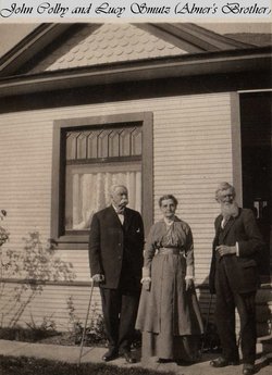
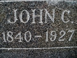

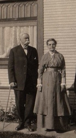
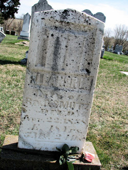
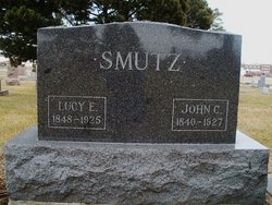
John Colby Smutz
| Birth | : | 15 Dec 1840 Westmoreland County, Pennsylvania, USA |
| Death | : | 29 Oct 1927 Los Angeles, Los Angeles County, California, USA |
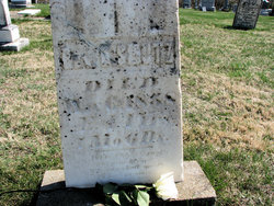
| Burial | : | Pawnee City Cemetery, Pawnee City, Pawnee County, USA |
| Coordinate | : | 40.1109009, -96.1608810 |
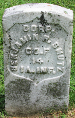
| Description | : | Son of David Smutz & Eleanor Armstrong Smutz. Married to Lucinda Edna Beach on July 10, 1872 in Lee County, Iowa. (Pawnee Library, book of obits in the Pawnee Republican.) (The following is posted courtesy of the Table Rock Historical Society.) Table Rock Argus, July 28, 1922. At their home in Pawnee City Mr. and Mrs. J. C. Smutz celebrated their "Golden Wedding" anniversary Monday, July 10th. This couple were married in South eastern Iowa, July 4, 1872 and came soon after to Pawnee county. The groom had journeyed to West Branch precinct three years prior to this and taken a homestead. He taught school... Read More |
frequently asked questions (FAQ):
-
Where is John Colby Smutz's memorial?
John Colby Smutz's memorial is located at: Pawnee City Cemetery, Pawnee City, Pawnee County, USA.
-
When did John Colby Smutz death?
John Colby Smutz death on 29 Oct 1927 in Los Angeles, Los Angeles County, California, USA
-
Where are the coordinates of the John Colby Smutz's memorial?
Latitude: 40.1109009
Longitude: -96.1608810
Family Members:
Parent
Spouse
Siblings
Children
Flowers:


Nearby Cemetories:
1. Pawnee City Cemetery
Pawnee City, Pawnee County, USA
Coordinate: 40.1109009, -96.1608810
2. East Amish Cemetery
Table Rock, Pawnee County, USA
Coordinate: 40.1310000, -96.0854000
3. Evergreen Cemetery
Pawnee County, USA
Coordinate: 40.0485992, -96.1417007
4. Pleasant Valley Cemetery
Pawnee County, USA
Coordinate: 40.0299988, -96.1554794
5. Table Rock Cemetery
Table Rock, Pawnee County, USA
Coordinate: 40.1791400, -96.1037400
6. Prairie Star Pioneer Cemetery
Du Bois, Pawnee County, USA
Coordinate: 40.0293000, -96.1041000
7. Beranek Cemetery
Table Rock, Pawnee County, USA
Coordinate: 40.2042007, -96.1607971
8. Pleasant Ridge Cemetery
Du Bois, Pawnee County, USA
Coordinate: 40.0156000, -96.1494000
9. West Branch Cemetery
Pawnee County, USA
Coordinate: 40.0787940, -96.2797160
10. Saint Anthonys Cemetery
Steinauer, Pawnee County, USA
Coordinate: 40.2075005, -96.2189026
11. Johnson Creek Cemetery
Pawnee City, Pawnee County, USA
Coordinate: 40.0270000, -96.2465000
12. Clear Creek Cemetery
Table Rock, Pawnee County, USA
Coordinate: 40.2193985, -96.1391983
13. Bohemian Cemetery
Table Rock, Pawnee County, USA
Coordinate: 40.1786003, -96.0374985
14. Saint Peters Evangelican Cemetery
Du Bois, Pawnee County, USA
Coordinate: 40.0010000, -96.1095000
15. Dry Branch Pioneer Cemetery
Richardson County, USA
Coordinate: 40.1292000, -96.0100021
16. DuBois Cemetery
Du Bois, Pawnee County, USA
Coordinate: 40.0231018, -96.0488968
17. Bohemian Cemetery
Richardson County, USA
Coordinate: 40.1175003, -95.9955978
18. Saint Johns Cemetery
Table Rock, Pawnee County, USA
Coordinate: 40.2148000, -96.0657000
19. Salems Cemetery
Steinauer, Pawnee County, USA
Coordinate: 40.2166000, -96.2555000
20. McCaffrey Cemetery
Nemaha County, USA
Coordinate: 39.9827100, -96.1474500
21. Madden Cemetery
Axtell, Marshall County, USA
Coordinate: 39.9866800, -96.2490300
22. Friedens United Church of Christ Cemetery
Bern, Nemaha County, USA
Coordinate: 39.9929008, -96.0529480
23. Saint Peters Lutheran Church Cemetery
Steinauer, Pawnee County, USA
Coordinate: 40.2555000, -96.1801000
24. Cincinnati Cemetery
Du Bois, Pawnee County, USA
Coordinate: 40.0042000, -96.0274963