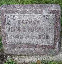
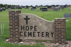
John D. Hospers
| Birth | : | 15 Mar 1893 Orange City, Sioux County, Iowa, USA |
| Death | : | 4 Nov 1939 Hull, Sioux County, Iowa, USA |
| Burial | : | St. Mary Magdalene's Churchyard, Oxford, City of Oxford, England |
| Coordinate | : | 51.7546250, -1.2588340 |
| Description | : | John D. Hospers were born in Orange City in 1893 where he grew to manhood. Later he was employed around Hull and met Dena Te Slaa who became his wife. Three sons were born to this union. John W., Garrett and Alvin. He was critically ill with the flu some 20 years ago. They lived north of Hull three years, one year at Sheldon and since then on a farm south of Hull. He became ill in the winter of 1935 and was operated on at the Hull hospital, later underwent several major operations at Iowa City which seemingly improved... Read More |
frequently asked questions (FAQ):
-
Where is John D. Hospers's memorial?
John D. Hospers's memorial is located at: St. Mary Magdalene's Churchyard, Oxford, City of Oxford, England.
-
When did John D. Hospers death?
John D. Hospers death on 4 Nov 1939 in Hull, Sioux County, Iowa, USA
-
Where are the coordinates of the John D. Hospers's memorial?
Latitude: 51.7546250
Longitude: -1.2588340
Family Members:
Spouse
Children
Flowers:
Nearby Cemetories:
1. St. Mary Magdalene's Churchyard
Oxford, City of Oxford, England
Coordinate: 51.7546250, -1.2588340
2. Martyrs' Memorial
Oxford, City of Oxford, England
Coordinate: 51.7550900, -1.2590100
3. St. Michael at the North Gate Church
Oxford, City of Oxford, England
Coordinate: 51.7537210, -1.2583950
4. Balliol College Chapel
Oxford, City of Oxford, England
Coordinate: 51.7547800, -1.2572240
5. Trinity College Chapel
Oxford, City of Oxford, England
Coordinate: 51.7552360, -1.2569620
6. St Johns College
Oxford, City of Oxford, England
Coordinate: 51.7560820, -1.2589910
7. Jesus College Chapel
Oxford, City of Oxford, England
Coordinate: 51.7536130, -1.2566180
8. Blackfriars
Oxford, City of Oxford, England
Coordinate: 51.7561210, -1.2602060
9. Exeter College Chapel
Oxford, City of Oxford, England
Coordinate: 51.7539460, -1.2561170
10. All Saints Churchyard
Oxford, City of Oxford, England
Coordinate: 51.7525000, -1.2555560
11. Austin Friars Church
Oxford, City of Oxford, England
Coordinate: 51.7553710, -1.2541550
12. University Church of St Mary the Virgin
Oxford, City of Oxford, England
Coordinate: 51.7523990, -1.2556000
13. Saint Peter le Bailey Churchyard
Oxford, City of Oxford, England
Coordinate: 51.7516980, -1.2600300
14. St Martin's Church, Carfax (Defunct)
Oxford, City of Oxford, England
Coordinate: 51.7513500, -1.2581700
15. Wadham College Chapel
Oxford, City of Oxford, England
Coordinate: 51.7560700, -1.2540350
16. Oxford Castle and Prison Cemetery
Oxford, City of Oxford, England
Coordinate: 51.7521453, -1.2631165
17. St Ebbe Churchyard
Oxford, City of Oxford, England
Coordinate: 51.7504200, -1.2596030
18. New College
Oxford, City of Oxford, England
Coordinate: 51.7543090, -1.2515310
19. St Giles Churchyard
Oxford, City of Oxford, England
Coordinate: 51.7591660, -1.2605170
20. University College Chapel
Oxford, City of Oxford, England
Coordinate: 51.7522100, -1.2521700
21. Oriel College Ante-Chapel
Oxford, City of Oxford, England
Coordinate: 51.7512420, -1.2531940
22. Mansfield College Chapel
Oxford, City of Oxford, England
Coordinate: 51.7576410, -1.2523340
23. Corpus Christi College Chapel
Oxford, City of Oxford, England
Coordinate: 51.7507010, -1.2534236
24. Queens College Chapel
Oxford, City of Oxford, England
Coordinate: 51.7532340, -1.2506990

