
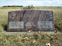

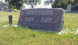
John Dale “Jack” Crowdell
| Birth | : | 8 Oct 1922 York County, Nebraska, USA |
| Death | : | 29 Jul 1996 York County, Nebraska, USA |
| Burial | : | Reese Cemetery, Springfield, Calhoun County, USA |
| Coordinate | : | 42.3196983, -85.2375031 |
| Description | : | Jack Crowdell (WA0BOK) was the voice of WA0HOU Repeater, sponsored by the Blue Valley Amateur Radio Club. He was instrumental in the management of the ARES (Amateur Radio Emergency Services) Nets on the repeater. When threatening weather moved into the York-Polk-Seward-Lancaster areas, Jack was always there. He also participated in many other ham and civic functions. WA0BOK was respected by all who new him. Jack became a silent key on July 29, 1996. Just because your key went silent, we all know your spark is still present. 73's Jack, from all your Ham friends. We'll catch you a little later... Read More |
frequently asked questions (FAQ):
-
Where is John Dale “Jack” Crowdell's memorial?
John Dale “Jack” Crowdell's memorial is located at: Reese Cemetery, Springfield, Calhoun County, USA.
-
When did John Dale “Jack” Crowdell death?
John Dale “Jack” Crowdell death on 29 Jul 1996 in York County, Nebraska, USA
-
Where are the coordinates of the John Dale “Jack” Crowdell's memorial?
Latitude: 42.3196983
Longitude: -85.2375031
Family Members:
Parent

Siblings
Flowers:


Nearby Cemetories:
1. Youngs Cemetery
Battle Creek, Calhoun County, USA
Coordinate: 42.3031693, -85.2358398
2. Memorial Park Sunset Gardens
Battle Creek, Calhoun County, USA
Coordinate: 42.3010950, -85.2393690
3. Memorial Park Cemetery
Battle Creek, Calhoun County, USA
Coordinate: 42.3005981, -85.2358017
4. Haskell Home Cemetery
Battle Creek, Calhoun County, USA
Coordinate: 42.3350590, -85.2093310
5. Harmonia Cemetery
Bedford, Calhoun County, USA
Coordinate: 42.3436012, -85.2782974
6. Harmon Halladay Cemetery
Bedford, Calhoun County, USA
Coordinate: 42.3546982, -85.2061005
7. Saint Thomas Episcopal Church Memorial Gardens
Battle Creek, Calhoun County, USA
Coordinate: 42.3208710, -85.1795390
8. Mount Olivet Cemetery
Battle Creek, Calhoun County, USA
Coordinate: 42.3074989, -85.1817017
9. Oak Hill Cemetery
Battle Creek, Calhoun County, USA
Coordinate: 42.3060989, -85.1774979
10. Beckley Cemetery
Battle Creek, Calhoun County, USA
Coordinate: 42.2633018, -85.2375031
11. Fort Custer National Cemetery
Augusta, Kalamazoo County, USA
Coordinate: 42.3384514, -85.3191986
12. Dubois Cemetery
Battle Creek, Calhoun County, USA
Coordinate: 42.2606010, -85.1956024
13. Bedford Cemetery
Bedford Township, Calhoun County, USA
Coordinate: 42.3938103, -85.2306671
14. Lawler Cemetery
Augusta, Kalamazoo County, USA
Coordinate: 42.3050003, -85.3469009
15. Morgan Cemetery
Battle Creek, Calhoun County, USA
Coordinate: 42.2397003, -85.1983032
16. Augusta Cemetery
Augusta, Kalamazoo County, USA
Coordinate: 42.3392240, -85.3566830
17. Day Cemetery
Augusta, Kalamazoo County, USA
Coordinate: 42.3905983, -85.3285980
18. Roof Cemetery
Climax, Kalamazoo County, USA
Coordinate: 42.2538986, -85.3368988
19. Floral Lawn Memorial Gardens
Battle Creek, Calhoun County, USA
Coordinate: 42.3055992, -85.1033020
20. West Leroy Cemetery
West Leroy, Calhoun County, USA
Coordinate: 42.2241660, -85.2822220
21. Hicks Cemetery
Pennfield Township, Calhoun County, USA
Coordinate: 42.3883018, -85.1335983
22. Newbre Cemetery
Battle Creek, Calhoun County, USA
Coordinate: 42.2606010, -85.1196976
23. Ross Center Cemetery
Augusta, Kalamazoo County, USA
Coordinate: 42.3760986, -85.3619003
24. Prairie Home Cemetery
Climax, Kalamazoo County, USA
Coordinate: 42.2351189, -85.3364410