
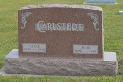
John Edward Carlstedt
| Birth | : | 18 Mar 1896 Stratford, Hamilton County, Iowa, USA |
| Death | : | 26 Mar 1968 Webster City, Hamilton County, Iowa, USA |
| Burial | : | South Marion Cemetery, Stratford, Hamilton County, USA |
| Coordinate | : | 42.2327995, -93.8735962 |
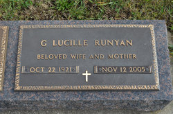
| Description | : | Daily Freeman Journal April 2, 1968 OBITUARY JOHN CARLSTEDT STRATFORD - John Carlstedt, 72, rural Stratford farmer, passed away at the Hamilton County Hospital, Webster City, Tuesday morning, March 26, after a lingering illness. Services were held Friday at 2 p.m. in the South Marion Methodist Church, with Rev. George Brighton officiating. Burial was in the South Marion Cemetery, with the Hanson Funeral Home of Stratford in charge of arrangements. Mr. Carlstedt is survived by his wife, Grace; one daughter, Mrs. Clifford (Lucille) Runyan of Newell; nine grandchildren; four sisters, Mrs. Oscar (Anna) Peterson, Mrs. Elsie... Read More |
frequently asked questions (FAQ):
-
Where is John Edward Carlstedt's memorial?
John Edward Carlstedt's memorial is located at: South Marion Cemetery, Stratford, Hamilton County, USA.
-
When did John Edward Carlstedt death?
John Edward Carlstedt death on 26 Mar 1968 in Webster City, Hamilton County, Iowa, USA
-
Where are the coordinates of the John Edward Carlstedt's memorial?
Latitude: 42.2327995
Longitude: -93.8735962
Family Members:
Parent

Spouse

Siblings
Children
Flowers:


Nearby Cemetories:
1. South Marion Cemetery
Stratford, Hamilton County, USA
Coordinate: 42.2327995, -93.8735962
2. Oakwood Cemetery
Stratford, Hamilton County, USA
Coordinate: 42.2942009, -93.9182968
3. Mineral Ridge Cemetery
Ridgeport, Boone County, USA
Coordinate: 42.1749992, -93.9266968
4. Hooks Point Cemetery
Hamilton County, USA
Coordinate: 42.2944530, -93.9199090
5. Hardin Township Cemetery
Hardin Township, Webster County, USA
Coordinate: 42.2411003, -93.9708023
6. Saint Paul Lutheran Cemetery
Boone, Boone County, USA
Coordinate: 42.1700000, -93.8070000
7. Boone County Poor Farm Cemetery
Boone County, USA
Coordinate: 42.1591100, -93.9159000
8. White Cemetery
Boone County, USA
Coordinate: 42.1777992, -93.9636002
9. Lake Center Cemetery
Stanhope, Hamilton County, USA
Coordinate: 42.2482986, -93.7568970
10. Leininger Cemetery
Boone County, USA
Coordinate: 42.1492004, -93.8356018
11. Lawn Hill Cemetery
Stanhope, Hamilton County, USA
Coordinate: 42.2677994, -93.7611008
12. Nesse Cemetery
Hamilton County, USA
Coordinate: 42.3250008, -93.8933029
13. Neese Cemetery
Homer, Hamilton County, USA
Coordinate: 42.3250000, -93.8935000
14. Linn Cemetery
Pilot Mound, Boone County, USA
Coordinate: 42.2045330, -93.9970230
15. Vegors Cemetery
Webster County, USA
Coordinate: 42.3177986, -93.9421997
16. Mackey Cemetery
Boone County, USA
Coordinate: 42.1675000, -93.7565000
17. Runyan Cemetery
Pilot Mound, Boone County, USA
Coordinate: 42.1749992, -94.0015030
18. Saint Pauls Church Cemetery
Jewell, Hamilton County, USA
Coordinate: 42.2490100, -93.7173400
19. Schlicht Cemetery
Fraser, Boone County, USA
Coordinate: 42.1444200, -93.9780100
20. Bass Cemetery
Dayton, Webster County, USA
Coordinate: 42.2966995, -94.0149994
21. Saratoga Cemetery
Stanhope, Hamilton County, USA
Coordinate: 42.3539009, -93.8167038
22. Pilot Mound Cemetery
Pilot Mound, Boone County, USA
Coordinate: 42.1636200, -94.0282600
23. Ellsworth Clear Lake Cemetery
Randall, Hamilton County, USA
Coordinate: 42.2268930, -93.6926200
24. Bass Point Cemetery
Boone, Boone County, USA
Coordinate: 42.0992012, -93.8957977