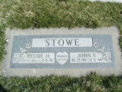
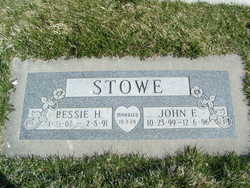
John Emmett Stowe
| Birth | : | 23 Oct 1899 Clever, Christian County, Missouri, USA |
| Death | : | 6 Dec 1996 Brewster, Okanogan County, Washington, USA |
| Burial | : | Trangie General Cemetery, Trangie, Narromine Shire, Australia |
| Coordinate | : | -32.0342840, 147.9731270 |
| Plot | : | Row 21, Steet 3 Alley 11, Lot 1 |
| Inscription | : | Bessie Stowe m: 3 Oct 1924 |
| Description | : | JOHN E. STOWE - Monday - December 9, 1996 John E. Stowe, 97, Brewster, died Friday, Dec. 6, 1996, in the Okanogan-Douglas Hospital in Brewster. He was born on Oct. 23, 1899, the son of Robert and Laura (Raper) Stowe at Clever, Mo. On Oct. 3, 1924, he married Bessie H. Hendrickson at Conway, Ark. They moved their family to Oroville in 1942, where he worked in construction and at various jobs. In 1962, they moved to Manson and in 1965, to Seattle. They moved to Brewster for a short time and moved to Sumner until 1989,... Read More |
frequently asked questions (FAQ):
-
Where is John Emmett Stowe's memorial?
John Emmett Stowe's memorial is located at: Trangie General Cemetery, Trangie, Narromine Shire, Australia.
-
When did John Emmett Stowe death?
John Emmett Stowe death on 6 Dec 1996 in Brewster, Okanogan County, Washington, USA
-
Where are the coordinates of the John Emmett Stowe's memorial?
Latitude: -32.0342840
Longitude: 147.9731270
Family Members:
Parent
Spouse
Siblings
Children
Flowers:
Nearby Cemetories:
1. Trangie General Cemetery
Trangie, Narromine Shire, Australia
Coordinate: -32.0342840, 147.9731270
2. Narromine War Cemetery
Narromine, Narromine Shire, Australia
Coordinate: -32.2528038, 148.2276306
3. Narromine General Cemetery
Narromine, Narromine Shire, Australia
Coordinate: -32.2481700, 148.2424500
4. Albert Cemetery
Condobolin, Lachlan Shire, Australia
Coordinate: -32.3810880, 147.4815200
5. Lone Graves
Ballimore, Dubbo Regional Council, Australia
Coordinate: -32.2456190, 148.6043360
6. Tottenham Cemetery
Tottenham, Lachlan Shire, Australia
Coordinate: -32.2408450, 147.3384250
7. Tomingley Pioneer Cemetery
Tomingley, Narromine Shire, Australia
Coordinate: -32.5676890, 148.2326270
8. Western Districts Memorial Park
Dubbo, Dubbo Regional Council, Australia
Coordinate: -32.2045930, 148.6267630
9. Old Dubbo Cemetery
Dubbo, Dubbo Regional Council, Australia
Coordinate: -32.2403680, 148.6283760
10. New Dubbo Cemetery
Dubbo, Dubbo Regional Council, Australia
Coordinate: -32.2323520, 148.6433290
11. Dubbo Pioneer Cemetery
Dubbo, Dubbo Regional Council, Australia
Coordinate: -32.3147740, 148.6243340
12. Mudgee Memorial Park Cemetery
Mudgee, Mid-Western Regional Council, Australia
Coordinate: -32.5914610, 147.5831910
13. Gilgandra General Cemetery
Gilgandra, Gilgandra Shire, Australia
Coordinate: -31.7130465, 148.6877720
14. Peak Hill General Cemetery
Peak Hill, Parkes Shire, Australia
Coordinate: -32.7246090, 148.1911620
15. Curban General Cemetery
Curban, Gilgandra Shire, Australia
Coordinate: -31.5280680, 148.6062240
16. Armatree Sunnyside Cemetery
Armatree, Gilgandra Shire, Australia
Coordinate: -31.4235363, 148.5125427
17. Nyngan General Cemetery
Nyngan, Bogan Shire, Australia
Coordinate: -31.5738770, 147.2066920
18. Gulargambone General Cemetery
Gulargambone, Coonamble Shire, Australia
Coordinate: -31.3394870, 148.4695380
19. Geurie Cemetery
Geurie, Dubbo Regional Council, Australia
Coordinate: -32.4118100, 148.8326300
20. Kadina
Parkes, Parkes Shire, Australia
Coordinate: -32.8831010, 148.2715490
21. Fifield Cemetery
Fifield, Lachlan Shire, Australia
Coordinate: -32.8073160, 147.4434050
22. Elong Elong Cemetery
Elong Elong, Dubbo Regional Council, Australia
Coordinate: -32.1117050, 149.0363750
23. Yeoval General Cemetery
Yeoval, Cabonne Shire, Australia
Coordinate: -32.7360660, 148.6614970
24. Alectown Cemetery
Alectown, Parkes Shire, Australia
Coordinate: -32.9241400, 148.2415760


