
| Birth | : | 2 Jan 1805 |
| Death | : | 26 Jan 1875 |
| Burial | : | Sandy Creek Baptist Church Cemetery, Liberty, Randolph County, USA |
| Coordinate | : | 35.8235550, -79.6429050 |
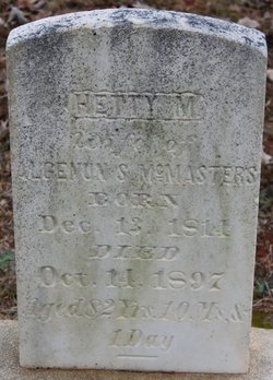
| Description | : | John Fruit married Mary "Polly" McMasters on March 3, 1826 in Randolph County, NC. ======================= John Fruit United States Census, 1850 Name John Fruit Event Type Census Event Year 1850 Event Place Randolph county, part of, Randolph, NC, US Gender Male Age 45 Race White ... Read More |
frequently asked questions (FAQ):
-
Where is John Fruit's memorial?
John Fruit's memorial is located at: Sandy Creek Baptist Church Cemetery, Liberty, Randolph County, USA.
-
When did John Fruit death?
John Fruit death on 26 Jan 1875 in
-
Where are the coordinates of the John Fruit's memorial?
Latitude: 35.8235550
Longitude: -79.6429050
Family Members:
Parent

Spouse
Children

Flowers:


Nearby Cemetories:
1. Sandy Creek Baptist Church Cemetery
Liberty, Randolph County, USA
Coordinate: 35.8235550, -79.6429050
2. Sandy Creek Primitive Baptist Church Cemetery
Liberty, Randolph County, USA
Coordinate: 35.8239020, -79.6406560
3. Melanchthon Lutheran Church Cemetery
Liberty, Randolph County, USA
Coordinate: 35.8451630, -79.6440640
4. Cool Springs Baptist Church Cemetery
Franklinville, Randolph County, USA
Coordinate: 35.8072420, -79.6805660
5. McMasters Cemetery
Randolph County, USA
Coordinate: 35.8072370, -79.6021500
6. Whites Chapel United Methodist Church Cemetery
Liberty, Randolph County, USA
Coordinate: 35.7850520, -79.6422990
7. Bethany United Methodist Church Cemetery #2
Liberty, Randolph County, USA
Coordinate: 35.8430060, -79.5948160
8. Grays Chapel Cemetery
Grays Chapel, Randolph County, USA
Coordinate: 35.8183570, -79.6986060
9. Patterson Grove Christian Church Cemetery
Ramseur, Randolph County, USA
Coordinate: 35.7743940, -79.6536550
10. Hollys Chapel Pentecostal Holiness Church
Ramseur, Randolph County, USA
Coordinate: 35.7825600, -79.6048200
11. Mount Pleasant Baptist Church Cemetery
Staley, Randolph County, USA
Coordinate: 35.8144700, -79.5790000
12. Saint Stephen Memorial Gardens
Liberty, Randolph County, USA
Coordinate: 35.8550750, -79.5877970
13. Amos Grove Cemetery
Liberty, Randolph County, USA
Coordinate: 35.8546982, -79.5871964
14. Fairview Cemetery
Liberty, Randolph County, USA
Coordinate: 35.8516998, -79.5761032
15. Shady Grove Baptist Church Cemetery
Staley, Randolph County, USA
Coordinate: 35.7853800, -79.5821020
16. Margarets Chapel Church Cemetery
Staley, Randolph County, USA
Coordinate: 35.8110940, -79.5648900
17. Whites Memorial Baptist Church Cemetery
Franklinville, Randolph County, USA
Coordinate: 35.7939680, -79.7149760
18. Red Cross Baptist Church Cemetery
Redcross, Randolph County, USA
Coordinate: 35.8715591, -79.6995850
19. Lineberry Family Cemetery
Staley, Randolph County, USA
Coordinate: 35.7878000, -79.5724000
20. Old Shady Grove Cemetery
Staley, Randolph County, USA
Coordinate: 35.7874985, -79.5725021
21. York Family Cemetery
Ramseur, Randolph County, USA
Coordinate: 35.7603000, -79.6108000
22. Olivers Chapel Cemetery
Staley, Randolph County, USA
Coordinate: 35.8060989, -79.5610962
23. Shiloh United Methodist Church Cemetery
Liberty, Randolph County, USA
Coordinate: 35.8915430, -79.6594990
24. Bethel United Methodist Church Cemetery
Randolph County, USA
Coordinate: 35.8779190, -79.7051540