
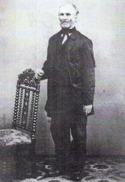

John Gangewehr Bruner
| Birth | : | 24 Jun 1802 Lower Saucon, Northampton County, Pennsylvania, USA |
| Death | : | 19 Jan 1886 West Point, Cuming County, Nebraska, USA |
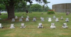
| Burial | : | Elmswell Cemetery, Elmswell, Mid Suffolk District, England |
| Coordinate | : | 52.2328720, 0.8992110 |
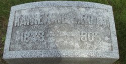
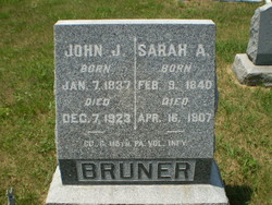
| Description | : | Children - Caroline E, Andrew J, Uriah E, Katherine E, John J, Bellinda E, James B, Charles E, Thomas C, and Jacob A. John G Bruner's parents were Andrew John and Christina Gangewehr Brunner. |
frequently asked questions (FAQ):
-
Where is John Gangewehr Bruner's memorial?
John Gangewehr Bruner's memorial is located at: Elmswell Cemetery, Elmswell, Mid Suffolk District, England.
-
When did John Gangewehr Bruner death?
John Gangewehr Bruner death on 19 Jan 1886 in West Point, Cuming County, Nebraska, USA
-
Where are the coordinates of the John Gangewehr Bruner's memorial?
Latitude: 52.2328720
Longitude: 0.8992110
Family Members:
Parent
Spouse
Siblings
Children

Flowers:


Nearby Cemetories:
1. Elmswell Cemetery
Elmswell, Mid Suffolk District, England
Coordinate: 52.2328720, 0.8992110
2. St John the Divine Churchyard
Elmswell, Mid Suffolk District, England
Coordinate: 52.2350000, 0.9014815
3. Methodist Church Burial Ground
Elmswell, Mid Suffolk District, England
Coordinate: 52.2371320, 0.9097780
4. All Saints Churchyard
Drinkstone, Mid Suffolk District, England
Coordinate: 52.2178910, 0.8674070
5. Norton Baptist Church
Norton, Mid Suffolk District, England
Coordinate: 52.2541360, 0.8657970
6. St. Andrew's Churchyard
Norton, Mid Suffolk District, England
Coordinate: 52.2600350, 0.8737990
7. King Charles the Martyr Churchyard
Shelland, Mid Suffolk District, England
Coordinate: 52.2039070, 0.9307170
8. Rattlesden Cemetery
Rattlesden, Mid Suffolk District, England
Coordinate: 52.1961530, 0.8947200
9. St Nicholas Churchyard
Rattlesden, Mid Suffolk District, England
Coordinate: 52.1941810, 0.8926210
10. Rattlesden Baptist Church
Rattlesden, Mid Suffolk District, England
Coordinate: 52.1924020, 0.8885300
11. St. Mary the Virgin's Church
Haughley, Mid Suffolk District, England
Coordinate: 52.2215800, 0.9647260
12. St Ethelbert Churchyard
Hessett, Mid Suffolk District, England
Coordinate: 52.2206810, 0.8341060
13. All Saints Churchyard
Great Ashfield, Mid Suffolk District, England
Coordinate: 52.2719990, 0.9234480
14. St Michael Churchyard
Hunston, Mid Suffolk District, England
Coordinate: 52.2750420, 0.8947420
15. All Saints Churchyard
Beyton, Mid Suffolk District, England
Coordinate: 52.2290300, 0.8301100
16. St. Augustine's Church Burial Ground
Harleston, Mid Suffolk District, England
Coordinate: 52.2045920, 0.9526440
17. St George Churchyard
Stowlangtoft, Mid Suffolk District, England
Coordinate: 52.2771010, 0.8683970
18. St John the Baptist Churchyard
Onehouse, Mid Suffolk District, England
Coordinate: 52.1956290, 0.9495420
19. Badwell Ash Cemetery
Badwell Ash, Mid Suffolk District, England
Coordinate: 52.2822470, 0.9168550
20. St. Mary's in the Field
Langham, Mid Suffolk District, England
Coordinate: 52.2837690, 0.9022270
21. Saint Mary Churchyard
Badwell Ash, Mid Suffolk District, England
Coordinate: 52.2829360, 0.9152840
22. St. Mary's Churchyard
Gedding, Mid Suffolk District, England
Coordinate: 52.1865920, 0.8540510
23. Saint Mary's Churchyard
Buxhall, Mid Suffolk District, England
Coordinate: 52.1803740, 0.9283610
24. St Mary Parish Churchyard
Pakenham, St Edmundsbury Borough, England
Coordinate: 52.2678260, 0.8268340