

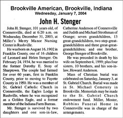
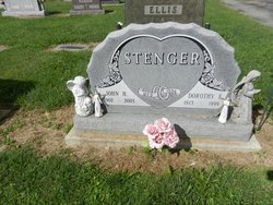
John H. Stenger
| Birth | : | 16 Aug 1902 Franklin County, Indiana, USA |
| Death | : | 31 Dec 2003 Rushville, Rush County, Indiana, USA |
| Burial | : | San Joaquin Valley National Cemetery, Santa Nella, Merced County, USA |
| Coordinate | : | 37.1198170, -121.0738000 |
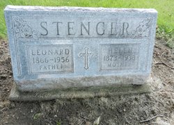
| Description | : | John H. Stegner, 101, of Connersville, died Wednesday, Dec. 31, 2003, at Miller's Merry Manor in Rushville. Born Aug. 16, 1902, in Franklin County, he was the son of Leonard and Helen Stegner, both deceased. He married Dorothy E. Story on Feb. 24, 1934; she preceded him in death. Mr. Stegner and his wife farmed in Franklin and Fayette counties for more than 60 years. He was a member of St. Gabriel Catholic Church, a former member of Indiana Farm Bureau, and a member of the Eagles Lodge in Rushville where he was recognized as a Golden Eagle. Survivors include two daughters, Catherine... Read More |
frequently asked questions (FAQ):
-
Where is John H. Stenger's memorial?
John H. Stenger's memorial is located at: San Joaquin Valley National Cemetery, Santa Nella, Merced County, USA.
-
When did John H. Stenger death?
John H. Stenger death on 31 Dec 2003 in Rushville, Rush County, Indiana, USA
-
Where are the coordinates of the John H. Stenger's memorial?
Latitude: 37.1198170
Longitude: -121.0738000
Family Members:
Parent

Spouse
Siblings
Flowers:


Nearby Cemetories:
1. San Joaquin Valley National Cemetery
Santa Nella, Merced County, USA
Coordinate: 37.1198170, -121.0738000
2. Cottonwood Cemetery
Gustine, Merced County, USA
Coordinate: 37.1878128, -121.0403900
3. Harper Family Cemetery
Los Banos, Merced County, USA
Coordinate: 37.0215379, -121.1236853
4. Calvary Cemetery
Los Banos, Merced County, USA
Coordinate: 37.0486800, -120.8547000
5. Los Banos Cemetery
Los Banos, Merced County, USA
Coordinate: 37.0470200, -120.8547000
6. Hills Ferry Cemetery
Newman, Stanislaus County, USA
Coordinate: 37.3321991, -121.0496979
7. Stevinson Sunnyside Cemetery
Stevinson, Merced County, USA
Coordinate: 37.3292007, -120.9231033
8. Colonel James J Stevinson Cemetery
Stevinson, Merced County, USA
Coordinate: 37.3572044, -120.9112320
9. South Hilmar Cemetery
Hilmar, Merced County, USA
Coordinate: 37.3802681, -120.8868408
10. North Hilmar Cemetery
Hilmar, Merced County, USA
Coordinate: 37.4146614, -120.8864288
11. Calvary-Sacred Heart Cemetery
Hollister, San Benito County, USA
Coordinate: 36.8483009, -121.3767014
12. Saint Benedicts Columbarium
Hollister, San Benito County, USA
Coordinate: 36.8337440, -121.3667120
13. Dos Palos Cemetery
Dos Palos, Merced County, USA
Coordinate: 36.9831009, -120.6357651
14. Odd Fellows Cemetery
Hollister, San Benito County, USA
Coordinate: 36.8571210, -121.4104100
15. Paul Gerber Memorial Cemetery
Santa Clara County, USA
Coordinate: 37.3637830, -121.4857920
16. Turlock Memorial Park
Turlock, Stanislaus County, USA
Coordinate: 37.4937592, -120.8659821
17. Saint Mary Church Cemetery
Gilroy, Santa Clara County, USA
Coordinate: 37.0155970, -121.5765950
18. Patterson District Cemetery
Patterson, Stanislaus County, USA
Coordinate: 37.5268135, -121.1728287
19. Saint Mary Cemetery
Gilroy, Santa Clara County, USA
Coordinate: 37.0134300, -121.5882000
20. Saint Francis Episcopal Church Columbarium
Turlock, Stanislaus County, USA
Coordinate: 37.5014300, -120.8368400
21. Gavilan Hills Memorial Park
Gilroy, Santa Clara County, USA
Coordinate: 37.0124000, -121.5909200
22. Paicines Cemetery
Paicines, San Benito County, USA
Coordinate: 36.7088580, -121.2456330
23. Winton Cemetery
Winton, Merced County, USA
Coordinate: 37.3820267, -120.6260223
24. Grayson Cemetery
Grayson, Stanislaus County, USA
Coordinate: 37.5594559, -121.1802826