
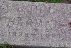
John Harman
| Birth | : | 1838 |
| Death | : | 1907 |
| Burial | : | Lompoc Evergreen Cemetery, Lompoc, Santa Barbara County, USA |
| Coordinate | : | 34.6296997, -120.4477997 |
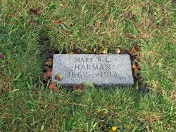
| Description | : | Harman Estate James Sloan, administrator of the estate of John Harman, deceased, has filed his final account and petition for distribution. It shows $8,885.89 received; $4,662.81 disbursed, $4,212.03 on hand. The heirs are the widow, Mary R. Harman, of Lompoc, Cal., four brothers residing in Iowa, Oklahoma, Nebraska and Berkeley, Cal; two sisters residing in Iowa: and 32 nephews and nieces residing, in various parts of the country. (Source: Lompoc Journal, Number 23, 22 Oct 1910) |
frequently asked questions (FAQ):
-
Where is John Harman's memorial?
John Harman's memorial is located at: Lompoc Evergreen Cemetery, Lompoc, Santa Barbara County, USA.
-
When did John Harman death?
John Harman death on 1907 in
-
Where are the coordinates of the John Harman's memorial?
Latitude: 34.6296997
Longitude: -120.4477997
Family Members:
Parent

Spouse
Siblings
Flowers:


Nearby Cemetories:
1. Lompoc Evergreen Cemetery
Lompoc, Santa Barbara County, USA
Coordinate: 34.6296997, -120.4477997
2. Mission La Purisima Concepcion Cemetery
Lompoc, Santa Barbara County, USA
Coordinate: 34.6716652, -120.4216690
3. Saint Mary's Episcopal Memory Garden
Lompoc, Santa Barbara County, USA
Coordinate: 34.6807100, -120.4533500
4. Guillermo Eduardo de la Guerra Burial Site
Los Alamos, Santa Barbara County, USA
Coordinate: 34.7500000, -120.3500000
5. Los Alamos Cemetery
Los Alamos, Santa Barbara County, USA
Coordinate: 34.7327995, -120.2807999
6. Pine Grove Cemetery
Santa Barbara County, USA
Coordinate: 34.8550430, -120.4185950
7. Solvang Cemetery
Solvang, Santa Barbara County, USA
Coordinate: 34.6017000, -120.1443920
8. Mission Santa Ines Cemetery
Solvang, Santa Barbara County, USA
Coordinate: 34.5943880, -120.1365550
9. Saint Mark's-in-the-Valley Church Mem. Garden
Los Olivos, Santa Barbara County, USA
Coordinate: 34.6662590, -120.1177210
10. San Ramon Chapel Cemetery
Santa Barbara County, USA
Coordinate: 34.8478012, -120.2394028
11. Oak Hill Cemetery
Ballard, Santa Barbara County, USA
Coordinate: 34.6324997, -120.1106033
12. Santa Maria Cemetery District
Santa Maria, Santa Barbara County, USA
Coordinate: 34.9369011, -120.4253006
13. Dudley-Hoffman Memory Gardens Columbarium
Santa Maria, Santa Barbara County, USA
Coordinate: 34.9388480, -120.4215260
14. Bethel Lutheran Church Resurrection Garden
Santa Maria, Santa Barbara County, USA
Coordinate: 34.9415700, -120.4279900
15. Ontiveros Cemetery
Los Alamos, Santa Barbara County, USA
Coordinate: 34.8897000, -120.2334900
16. Our Lady of Guadalupe Catholic Cemetery
Guadalupe, Santa Barbara County, USA
Coordinate: 34.9284800, -120.5911300
17. Rancho del Cielo Cemetery
Santa Barbara, Santa Barbara County, USA
Coordinate: 34.5304780, -120.0758920
18. Guadalupe Cemetery
Guadalupe, Santa Barbara County, USA
Coordinate: 34.9582863, -120.5741501
19. Capuchin Cemetery
Santa Ynez, Santa Barbara County, USA
Coordinate: 34.6442860, -120.0270440
20. Saint Joseph of Cupertino Province Cemetery
San Luis Obispo County, USA
Coordinate: 35.0718803, -120.5263519
21. Saint John's Lutheran Church Columbarium
Arroyo Grande, San Luis Obispo County, USA
Coordinate: 35.1032070, -120.5808630
22. Halcyon Cemetery
Halcyon, San Luis Obispo County, USA
Coordinate: 35.1062000, -120.5994990
23. Saint Barnabas Memorial Garden
Arroyo Grande, San Luis Obispo County, USA
Coordinate: 35.1179910, -120.5706380
24. Arroyo Grande Cemetery
Arroyo Grande, San Luis Obispo County, USA
Coordinate: 35.1230011, -120.5930634