

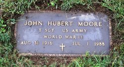
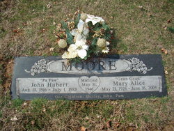
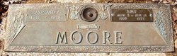
John Hubert Moore
| Birth | : | 31 Aug 1916 Farmington, St. Francois County, Missouri, USA |
| Death | : | 1 Jul 1988 Farmington, St. Francois County, Missouri, USA |
| Burial | : | Saint Marys Cemetery, Neillsville, Clark County, USA |
| Coordinate | : | 44.5681000, -90.5847015 |
| Description | : | John Hubert Moore, 71 of Farmington died July 1, at Farmington Regional Medical Center. He was born August 31, 1916 in Farmington, son of the late Joel Augustus and Ida Mae Piermont Moore and the grandson of Alexander & Margaret (nee Zolman) Moore. He was also preceded in death by one brother, Raymond Moore. A lifetime resident of this area, Mr. Moore was a retired postal clerk and a veteran of the U.S. Army Air Corps in World War II. He was a member of the Memorial United Methodist Church and the VFW. He is survived by his wife, Mary Alice... Read More |
frequently asked questions (FAQ):
-
Where is John Hubert Moore's memorial?
John Hubert Moore's memorial is located at: Saint Marys Cemetery, Neillsville, Clark County, USA.
-
When did John Hubert Moore death?
John Hubert Moore death on 1 Jul 1988 in Farmington, St. Francois County, Missouri, USA
-
Where are the coordinates of the John Hubert Moore's memorial?
Latitude: 44.5681000
Longitude: -90.5847015
Family Members:
Parent
Spouse
Siblings
Flowers:


Nearby Cemetories:
1. Saint Marys Cemetery
Neillsville, Clark County, USA
Coordinate: 44.5681000, -90.5847015
2. Neillsville City Cemetery
Neillsville, Clark County, USA
Coordinate: 44.5679321, -90.5836639
3. Clark County Poor Farm Cemetery
Granton, Clark County, USA
Coordinate: 44.6036800, -90.5364700
4. North Pine Valley Cemetery
Neillsville, Clark County, USA
Coordinate: 44.5896988, -90.6528015
5. Grant Cemetery
Granton, Clark County, USA
Coordinate: 44.5592995, -90.4895020
6. South Pine Valley Cemetery
Columbia, Clark County, USA
Coordinate: 44.5209590, -90.6646620
7. Chapel Hill Cemetery
Christie, Clark County, USA
Coordinate: 44.6467018, -90.6181030
8. Levis Cemetery
Neillsville, Clark County, USA
Coordinate: 44.4866982, -90.5999985
9. York Center Cemetery
Granton, Clark County, USA
Coordinate: 44.6321983, -90.5000000
10. West Weston Cemetery
Globe, Clark County, USA
Coordinate: 44.6394005, -90.6588974
11. Zion Cemetery
Granton, Clark County, USA
Coordinate: 44.5830994, -90.4542007
12. Zion American Lutheran Cemetery
Granton, Clark County, USA
Coordinate: 44.5681000, -90.4516983
13. Windfall Cemetery
Granton, Clark County, USA
Coordinate: 44.5946999, -90.4569016
14. Pine Grove Mennonite Cemetery
Granton, Clark County, USA
Coordinate: 44.5957590, -90.4560200
15. Columbia Cemetery
Columbia, Clark County, USA
Coordinate: 44.5238991, -90.7091980
16. Globe Lutheran Cemetery
Globe, Clark County, USA
Coordinate: 44.6552000, -90.6636000
17. Free Methodist Cemetery
Granton, Clark County, USA
Coordinate: 44.6546600, -90.5018000
18. Dells Dam Cemetery
Neillsville, Clark County, USA
Coordinate: 44.4757996, -90.6594009
19. Lone Grave Cemetery
Dewhurst, Clark County, USA
Coordinate: 44.5096893, -90.7201309
20. Lynn Cemetery
Lynn, Clark County, USA
Coordinate: 44.5816994, -90.3906021
21. Dewey Mike Cemetery
Neillsville, Clark County, USA
Coordinate: 44.4436989, -90.6753006
22. Seif Cemetery
Willard, Clark County, USA
Coordinate: 44.6688995, -90.7407990
23. Immanuel United Methodist Church Cemetery
Chili, Clark County, USA
Coordinate: 44.6128006, -90.3764038
24. Granton Amish Community Cemetery
Granton, Clark County, USA
Coordinate: 44.5838900, -90.3663800