
| Birth | : | 16 Aug 1885 |
| Death | : | 6 Jul 1960 |
| Burial | : | Union Baptist Church Cemetery, Lancaster County, USA |
| Coordinate | : | 34.7191280, -80.5989050 |
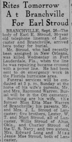
| Description | : | J. L. Stroud, 74, LancasterLancaster - John L. Stroud, 74, retired farmer of the Union community, died suddenly at his home Wednesday. He was the son of the late William H. and Martha Connell Stroud of Kershaw County. Survivors include his wife, Mrs. Bertha Mae Adams Stroud; two daughters, Mrs. Jessie Mae Tadlock of Rock Hill and Mrs. Georgia Lee Ball of Columbia; five sons, W. T. or the home, Mart of Lancaster, Lester of Detroit, Michigan, Willis of Layton, Oklahoma and Charlie of Rockport, Wash.; 23 grandchildren and seven great-grandchildren; two sisters. Mrs. Will Broome of Fort Mill and... Read More |
frequently asked questions (FAQ):
-
Where is John Levy Stroud's memorial?
John Levy Stroud's memorial is located at: Union Baptist Church Cemetery, Lancaster County, USA.
-
When did John Levy Stroud death?
John Levy Stroud death on 6 Jul 1960 in
-
Where are the coordinates of the John Levy Stroud's memorial?
Latitude: 34.7191280
Longitude: -80.5989050
Family Members:
Parent
Spouse

Siblings
Children
Flowers:


Nearby Cemetories:
1. Union Baptist Church Cemetery
Lancaster County, USA
Coordinate: 34.7191280, -80.5989050
2. Canaan Land Ministries Church Cemetery
Lancaster, Lancaster County, USA
Coordinate: 34.7177500, -80.6052000
3. New Zion Missionary Baptist Church Cemetery
Lancaster County, USA
Coordinate: 34.7207100, -80.6185490
4. Buford Battleground Memorial
Buford, Lancaster County, USA
Coordinate: 34.7427410, -80.6274600
5. High Point Baptist Church Cemetery
Lancaster County, USA
Coordinate: 34.6875660, -80.6322620
6. Laney-Knight Cemetery
Buford, Lancaster County, USA
Coordinate: 34.7427850, -80.5516480
7. Hopewell United Methodist Church Cemetery
Lancaster, Lancaster County, USA
Coordinate: 34.7385150, -80.6498510
8. Bethlehem Baptist Church Cemetery
Lancaster County, USA
Coordinate: 34.7592350, -80.6315860
9. Oak Hill Baptist Church SBC Cemetery
Lancaster, Lancaster County, USA
Coordinate: 34.7342690, -80.5266560
10. New Hope AME Zion Church Cemetery
Lancaster, Lancaster County, USA
Coordinate: 34.7569220, -80.6586460
11. Antioch Baptist Church Cemetery
Antioch, Lancaster County, USA
Coordinate: 34.7053185, -80.6746674
12. Rose Hill Baptist Church Cemetery
Tradesville, Lancaster County, USA
Coordinate: 34.7733040, -80.5575920
13. Spring Hill Baptist Church
Tradesville, Lancaster County, USA
Coordinate: 34.7719002, -80.5531769
14. White Bluff Baptist Church Cemetery
Lancaster, Lancaster County, USA
Coordinate: 34.6620280, -80.5572420
15. Fork Hill Cemetery
Fork Hill Crossroads, Lancaster County, USA
Coordinate: 34.6535988, -80.6205978
16. Byrd Cemetery
Taxahaw, Lancaster County, USA
Coordinate: 34.6919080, -80.5152830
17. Tabernacle United Methodist Church Cemetery
Lancaster, Lancaster County, USA
Coordinate: 34.7935982, -80.5922012
18. Rich Hill Baptist Church Cemetery
Lancaster County, USA
Coordinate: 34.6596090, -80.6561480
19. Pleasant Grove Baptist Church Cemetery
Heath Springs, Lancaster County, USA
Coordinate: 34.6551700, -80.6500370
20. Pleasant Dale Baptist Church Cemetery
Pleasant Dale, Lancaster County, USA
Coordinate: 34.7319740, -80.6920230
21. Taxahaw Baptist Church Cemetery
Taxahaw, Lancaster County, USA
Coordinate: 34.6857730, -80.5113190
22. Rowell Cemetery
Stewart Crossroads, Lancaster County, USA
Coordinate: 34.8037960, -80.6099080
23. New Cut Memorial Cemetery
Lancaster, Lancaster County, USA
Coordinate: 34.7803640, -80.6744440
24. Gills Creek Cemetery
Lancaster County, USA
Coordinate: 34.7300000, -80.7047000