
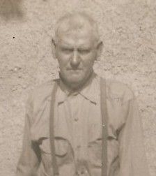
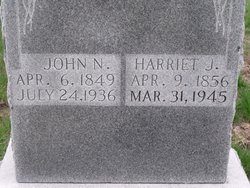


John Nulton Casteel
| Birth | : | 16 Apr 1849 Jackson County, Tennessee, USA |
| Death | : | 24 Jul 1936 Liberty Township, Schuyler County, Missouri, USA |
| Burial | : | Bucklin Cemetery, Bucklin, Ford County, USA |
| Coordinate | : | 37.5428009, -99.6436005 |
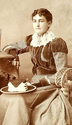
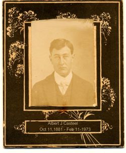
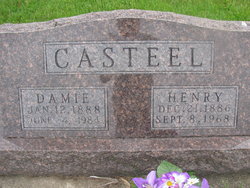
| Description | : | married, son of Joseph Casteel and Mary White d. cert 29482 indicates a death date of July 25, 1936 ------------ 1860 Missouri census, Schuyler County Joseph Casteel M 41 Kentucky Mary Casteel F 41 Tennessee John Casteel M 11 Tennessee William J Casteel M 7 Tennessee Nancy Casteel F 6 Tennessee Peter A Casteel M 1 Missouri Minerva Casteel F 0 Missouri ------------ 1870 Missouri census, Schuyler County |
frequently asked questions (FAQ):
-
Where is John Nulton Casteel's memorial?
John Nulton Casteel's memorial is located at: Bucklin Cemetery, Bucklin, Ford County, USA.
-
When did John Nulton Casteel death?
John Nulton Casteel death on 24 Jul 1936 in Liberty Township, Schuyler County, Missouri, USA
-
Where are the coordinates of the John Nulton Casteel's memorial?
Latitude: 37.5428009
Longitude: -99.6436005
Family Members:
Parent
Spouse

Siblings
Children
Flowers:


Nearby Cemetories:
1. Bucklin Cemetery
Bucklin, Ford County, USA
Coordinate: 37.5428009, -99.6436005
2. Sodville Cemetery
Ford County, USA
Coordinate: 37.5261002, -99.7508011
3. Ford Cemetery
Ford, Ford County, USA
Coordinate: 37.6319008, -99.7431030
4. Hillcrest Cemetery
Mullinville, Kiowa County, USA
Coordinate: 37.5922012, -99.4841995
5. Pleasant Valley Cemetery
Ford County, USA
Coordinate: 37.6880989, -99.6333008
6. McKinley Cemetery
Mullinville, Kiowa County, USA
Coordinate: 37.6324997, -99.4766998
7. Bloom Cemetery
Bloom, Ford County, USA
Coordinate: 37.4928017, -99.8966980
8. Lexington Cemetery
Lexington, Clark County, USA
Coordinate: 37.3231010, -99.5841980
9. Zion Lutheran Cemetery
Ford County, USA
Coordinate: 37.7779300, -99.6142500
10. Zion Lutheran Cemetery
Offerle, Edwards County, USA
Coordinate: 37.7779480, -99.6141880
11. Bethel Memorial Garden
Greensburg, Kiowa County, USA
Coordinate: 37.5578310, -99.3393690
12. Holy Cross Cemetery
Windthorst, Ford County, USA
Coordinate: 37.7874985, -99.6369019
13. Pioneer Cemetery
Wright, Ford County, USA
Coordinate: 37.7783360, -99.7872570
14. Bethel Cemetery
Hodges, Edwards County, USA
Coordinate: 37.7344017, -99.4131012
15. Fairview Cemetery
Greensburg, Kiowa County, USA
Coordinate: 37.6138992, -99.2866974
16. Kansas Veterans Cemetery at Fort Dodge
Dodge City, Ford County, USA
Coordinate: 37.7315903, -99.9314041
17. Saint Andrew Catholic Cemetery
Wright, Ford County, USA
Coordinate: 37.7790800, -99.8875100
18. Christ the King Cemetery
Ford County, USA
Coordinate: 37.6493073, -100.0056305
19. Saint Johns Cemetery
Spearville, Ford County, USA
Coordinate: 37.8381004, -99.7536011
20. Appleton Township Cemetery
Minneola, Clark County, USA
Coordinate: 37.4011002, -100.0046997
21. Pleasant Vale Cemetery
Ford County, USA
Coordinate: 37.7933006, -99.9047012
22. Wire Family Cemetery
Kinsley, Edwards County, USA
Coordinate: 37.8430200, -99.4510100
23. Silent Land Cemetery
Spearville, Ford County, USA
Coordinate: 37.8689003, -99.7530975
24. Protection Cemetery
Protection, Comanche County, USA
Coordinate: 37.2125015, -99.4946976