
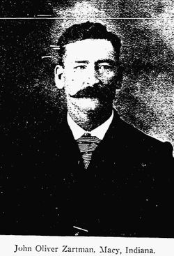
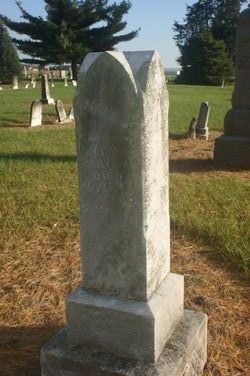
John Oliver “Jesse” Zartman
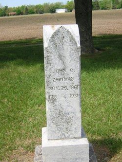
| Birth | : | 25 Nov 1861 Indiana, USA |
| Death | : | 3 Feb 1931 Miami County, Indiana, USA |
| Burial | : | St. John's Garden, Liverpool, Metropolitan Borough of Liverpool, England |
| Coordinate | : | 53.4087890, -2.9810070 |
| Description | : | OBITUARY The Rochester (IN) Sentinel Tuesday, February 3, 1931 John Oliver ZARTMAN, aged 70, who is better known as Jesse ZARTMAN, died at the home of his daugher, Mrs. Harry HATCH in Macy this morning at 9 o'clock following a several years illness due to a complication of diseases. For several years the deceased was an invalid. Mr. Zartman was born Nov. 25, 1861, on a farm north of Macy known as the Zula ZARTMAN farm and was one of 11 children who were born to George and Mary ZARTMAN. He has lived his entire lifetime... Read More |
frequently asked questions (FAQ):
-
Where is John Oliver “Jesse” Zartman's memorial?
John Oliver “Jesse” Zartman's memorial is located at: St. John's Garden, Liverpool, Metropolitan Borough of Liverpool, England.
-
When did John Oliver “Jesse” Zartman death?
John Oliver “Jesse” Zartman death on 3 Feb 1931 in Miami County, Indiana, USA
-
Where are the coordinates of the John Oliver “Jesse” Zartman's memorial?
Latitude: 53.4087890
Longitude: -2.9810070
Family Members:
Parent
Spouse
Siblings
Children
Flowers:


Nearby Cemetories:
1. St. John's Garden
Liverpool, Metropolitan Borough of Liverpool, England
Coordinate: 53.4087890, -2.9810070
2. Friends Burial Ground (Defunct)
Liverpool, Metropolitan Borough of Liverpool, England
Coordinate: 53.4111670, -2.9795830
3. St. Peter's Churchyard
Liverpool, Metropolitan Borough of Liverpool, England
Coordinate: 53.4051290, -2.9844200
4. Holy Trinity Churchyard
Liverpool, Metropolitan Borough of Liverpool, England
Coordinate: 53.4117490, -2.9759560
5. Roscoe Memorial Gardens
Liverpool, Metropolitan Borough of Liverpool, England
Coordinate: 53.4044040, -2.9762180
6. St. Anne's Churchyard
Liverpool, Metropolitan Borough of Liverpool, England
Coordinate: 53.4149050, -2.9782840
7. St. Paul's Churchyard
Liverpool, Metropolitan Borough of Liverpool, England
Coordinate: 53.4099460, -2.9919370
8. St. George's Churchyard
Liverpool, Metropolitan Borough of Liverpool, England
Coordinate: 53.4049700, -2.9901030
9. St. Andrew’s Churchyard
Liverpool, Metropolitan Borough of Liverpool, England
Coordinate: 53.4029730, -2.9726820
10. Metropolitan Cathedral of Christ the King
Liverpool, Metropolitan Borough of Liverpool, England
Coordinate: 53.4052820, -2.9685940
11. St. Thomas Churchyard
Liverpool, Metropolitan Borough of Liverpool, England
Coordinate: 53.4010330, -2.9861190
12. Brunswick Chapel
Liverpool, Metropolitan Borough of Liverpool, England
Coordinate: 53.4111280, -2.9675500
13. St. Nicholas' Churchyard
Liverpool, Metropolitan Borough of Liverpool, England
Coordinate: 53.4069350, -2.9951480
14. St Philip Graveyard
Liverpool, Metropolitan Borough of Liverpool, England
Coordinate: 53.4019240, -2.9719920
15. St Mary’s Parochial Cemetery
Liverpool, Metropolitan Borough of Liverpool, England
Coordinate: 53.4024370, -2.9672760
16. Liverpool Naval Memorial
Liverpool, Metropolitan Borough of Liverpool, England
Coordinate: 53.4061220, -2.9981050
17. St. Michaels Churchyard
Liverpool, Metropolitan Borough of Liverpool, England
Coordinate: 53.3976599, -2.9789353
18. Liverpool Cathedral
Liverpool, Metropolitan Borough of Liverpool, England
Coordinate: 53.3974310, -2.9731610
19. Liverpool Necropolis
Everton, Metropolitan Borough of Liverpool, England
Coordinate: 53.4146670, -2.9621830
20. St Martin-in-the-Fields Churchyard
Liverpool, Metropolitan Borough of Liverpool, England
Coordinate: 53.4210110, -2.9877860
21. St. Anthony's Churchyard
Liverpool, Metropolitan Borough of Liverpool, England
Coordinate: 53.4223190, -2.9815350
22. St James Garden Cemetery
Liverpool, Metropolitan Borough of Liverpool, England
Coordinate: 53.3960744, -2.9715005
23. St. James Churchyard
Toxteth, Metropolitan Borough of Liverpool, England
Coordinate: 53.3943720, -2.9750688
24. St. Mary's Churchyard
Edge Hill, Metropolitan Borough of Liverpool, England
Coordinate: 53.4065000, -2.9561600