John Polson
| Birth | : | 1825 |
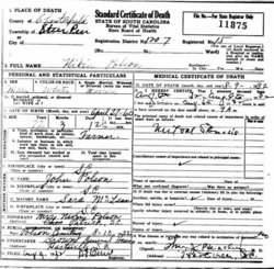
| Death | : | 12 Nov 1882 Chesterfield County, South Carolina, USA |
| Burial | : | Bear Creek Cemetery, Patrick, Chesterfield County, USA |
| Coordinate | : | 34.6122300, -80.0918340 |
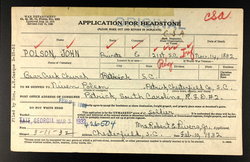
| Inscription | : | John Polson CO E 21 S. C. INF C S A |
| Description | : | John was married to Sarah McLean who was sometimes called Sarah Huggins. The 1880 U.S. census for Chesterfield County, SC lists his age at 55 years. His estate papers are on file at the South Carolina Dept of Archives and History in Columbia, wherein it states that he died at his home in Chesterfield County on or about October 1882. Note: CSA stone application lists death as November 14, 1882. It also lists burial as Bear Creek Cemetery. Note: The CSA marker was put near his home near Sugar Loaf Mountain according to family researchers. I believe him to be buried in... Read More |
frequently asked questions (FAQ):
-
Where is John Polson's memorial?
John Polson's memorial is located at: Bear Creek Cemetery, Patrick, Chesterfield County, USA.
-
When did John Polson death?
John Polson death on 12 Nov 1882 in Chesterfield County, South Carolina, USA
-
Where are the coordinates of the John Polson's memorial?
Latitude: 34.6122300
Longitude: -80.0918340
Family Members:
Children
Flowers:
Nearby Cemetories:
1. Bear Creek Cemetery
Patrick, Chesterfield County, USA
Coordinate: 34.6122300, -80.0918340
2. Saint John Freewill Baptist Church Cemetery
Chesterfield County, USA
Coordinate: 34.6128000, -80.1111000
3. Huggins-McLain Cemetery
Patrick, Chesterfield County, USA
Coordinate: 34.5917015, -80.0924988
4. Cross Branch Cemetery
Chesterfield County, USA
Coordinate: 34.6324997, -80.0836029
5. Pierce Cemetery
Patrick, Chesterfield County, USA
Coordinate: 34.6184529, -80.0608026
6. Bay Springs Baptist Church Cemetery
Bay Springs, Chesterfield County, USA
Coordinate: 34.6372860, -80.1167890
7. Fannie Cemetery
Chesterfield County, USA
Coordinate: 34.6352997, -80.0541992
8. Katie Polson Cemetery
Patrick, Chesterfield County, USA
Coordinate: 34.6166810, -80.1464870
9. Patrick Cemetery
Patrick, Chesterfield County, USA
Coordinate: 34.5746994, -80.0567017
10. Bethesda United Methodist Church Cemetery
Chesterfield, Chesterfield County, USA
Coordinate: 34.6422005, -80.0468979
11. Polson Cemetery
Patrick, Chesterfield County, USA
Coordinate: 34.5778480, -80.0467570
12. Palmetto Baptist Church Cemetery
Patrick, Chesterfield County, USA
Coordinate: 34.6035910, -80.1547270
13. Morning Star Baptist Church Cemetery
Patrick, Chesterfield County, USA
Coordinate: 34.5772100, -80.0437200
14. Saint James AME Zion Church Cemetery
Chesterfield County, USA
Coordinate: 34.6648470, -80.0721920
15. Mount Mary Baptist Church Cemetery
Chesterfield, Chesterfield County, USA
Coordinate: 34.6463050, -80.0383590
16. Roscoe-Cassidy Cemetery
Campbell Crossroads, Chesterfield County, USA
Coordinate: 34.6272011, -80.1577988
17. Mount Olive Church Cemetery
Patrick, Chesterfield County, USA
Coordinate: 34.5808400, -80.0330600
18. Cassidy Cemetery
Chesterfield County, USA
Coordinate: 34.5830994, -80.1536026
19. Bethlehem Church Cemetery
Middendorf, Chesterfield County, USA
Coordinate: 34.5605030, -80.1267820
20. Brown Cemetery
Chesterfield County, USA
Coordinate: 34.5952988, -80.1628036
21. Bethel United Methodist Church Cemetery
Ruby, Chesterfield County, USA
Coordinate: 34.6229840, -80.1655590
22. Green Family Cemetery
Chesterfield, Chesterfield County, USA
Coordinate: 34.6514260, -80.0319670
23. Ainsley Polson Cemetery
Patrick, Chesterfield County, USA
Coordinate: 34.5858600, -80.0204810
24. Peniel Cemetery
Chesterfield, Chesterfield County, USA
Coordinate: 34.6644170, -80.0460000


