

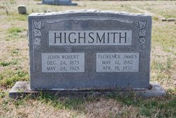
John Robert Highsmith
| Birth | : | 24 Dec 1873 Belvoir, Pitt County, North Carolina, USA |
| Death | : | 24 May 1928 Nash County, North Carolina, USA |
| Burial | : | St. Peter and St. Paul Churchyard, Fressingfield, Mid Suffolk District, England |
| Coordinate | : | 52.3487940, 1.3190390 |
| Description | : | Son of Robert Serle Highsmith and Millie Andrew Williams. Husband of Florence Agusta James. He was a lumberman. He was buried on May 25, 1928. |
frequently asked questions (FAQ):
-
Where is John Robert Highsmith's memorial?
John Robert Highsmith's memorial is located at: St. Peter and St. Paul Churchyard, Fressingfield, Mid Suffolk District, England.
-
When did John Robert Highsmith death?
John Robert Highsmith death on 24 May 1928 in Nash County, North Carolina, USA
-
Where are the coordinates of the John Robert Highsmith's memorial?
Latitude: 52.3487940
Longitude: 1.3190390
Family Members:
Parent
Spouse
Siblings

Flowers:


Nearby Cemetories:
1. St. Peter and St. Paul Churchyard
Fressingfield, Mid Suffolk District, England
Coordinate: 52.3487940, 1.3190390
2. Baptist Churchyard
Fressingfield, Mid Suffolk District, England
Coordinate: 52.3481570, 1.3216200
3. Fressingfield Methodist Churchyard
Fressingfield, Mid Suffolk District, England
Coordinate: 52.3472430, 1.3133970
4. Fressingfield Cemetery
Fressingfield, Mid Suffolk District, England
Coordinate: 52.3392240, 1.3135440
5. Metfield Cemetery
Metfield, Mid Suffolk District, England
Coordinate: 52.3678410, 1.3635810
6. Saint Mary Magdalene Churchyard
Metfield, Mid Suffolk District, England
Coordinate: 52.3773540, 1.3538467
7. Stradbroke Cemetery
Stradbroke, Mid Suffolk District, England
Coordinate: 52.3187700, 1.2831900
8. Saint John the Baptist Churchyard
Metfield, Mid Suffolk District, England
Coordinate: 52.3728810, 1.3689930
9. All Saints Churchyard
Stradbroke, Mid Suffolk District, England
Coordinate: 52.3186110, 1.2733720
10. St Peter Churchyard
Needham, South Norfolk District, England
Coordinate: 52.3896320, 1.2773700
11. All Saints Churchyard
Mendham, Mid Suffolk District, England
Coordinate: 52.3976310, 1.3349670
12. Laxfield Cemetery
Laxfield, Mid Suffolk District, England
Coordinate: 52.3022920, 1.3575990
13. St. Margaret's Churchyard
Syleham, Mid Suffolk District, England
Coordinate: 52.3641870, 1.2372060
14. Saint Mary's Churchyard
Cratfield, Suffolk Coastal District, England
Coordinate: 52.3227330, 1.3940450
15. Baptist's Church Burial Ground
Laxfield, Mid Suffolk District, England
Coordinate: 52.3015500, 1.3627300
16. St. Peter and St. Paul Churchyard
Brockdish, South Norfolk District, England
Coordinate: 52.3705240, 1.2366100
17. All Saints Churchyard
Laxfield, Mid Suffolk District, England
Coordinate: 52.3020950, 1.3663410
18. Church of the Assumption of the Blessed Virgin Mar
Redenhall, South Norfolk District, England
Coordinate: 52.4104780, 1.3272680
19. St. James' Churchyard
South Elmham St James, Waveney District, England
Coordinate: 52.3796890, 1.4113370
20. St Mary Churchyard
Horham, Mid Suffolk District, England
Coordinate: 52.3056620, 1.2408640
21. Horham Baptist Church
Horham, Mid Suffolk District, England
Coordinate: 52.2965910, 1.2536000
22. St. Margaret's Churchyard of Antioch
Linstead Parva, Suffolk Coastal District, England
Coordinate: 52.3477630, 1.4302960
23. St George's Churchyard
South Elmham St Cross, Waveney District, England
Coordinate: 52.4080410, 1.3794272
24. Saint John The Baptist Churchyard
Denham, Mid Suffolk District, England
Coordinate: 52.3275300, 1.2101200