
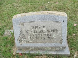
John Ryland Napier Sr.
| Birth | : | 23 Nov 1849 Nelson County, Virginia, USA |
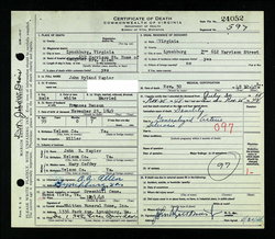
| Death | : | 30 Nov 1948 |
| Burial | : | Green Hill Cemetery, Buena Vista, Buena Vista City, USA |
| Coordinate | : | 37.7300200, -79.3758200 |
frequently asked questions (FAQ):
-
Where is John Ryland Napier Sr.'s memorial?
John Ryland Napier Sr.'s memorial is located at: Green Hill Cemetery, Buena Vista, Buena Vista City, USA.
-
When did John Ryland Napier Sr. death?
John Ryland Napier Sr. death on 30 Nov 1948 in
-
Where are the coordinates of the John Ryland Napier Sr.'s memorial?
Latitude: 37.7300200
Longitude: -79.3758200
Family Members:
Parent
Siblings

Children


Nearby Cemetories:
1. Green Hill Mausoleum
Buena Vista, Buena Vista City, USA
Coordinate: 37.7286700, -79.3759300
2. Hico Cemetery
Monroe, Amherst County, USA
Coordinate: 37.6875910, -79.3291640
3. Lipscombe-Garrett Cemetery
Amherst County, USA
Coordinate: 37.6834000, -79.3317000
4. Evergreen Cemetery
Lexington, Lexington City, USA
Coordinate: 37.7803001, -79.4321976
5. Oak Grove Cemetery
Lexington, Lexington City, USA
Coordinate: 37.7808300, -79.4450600
6. Virginia Military Institute Museum
Lexington, Lexington City, USA
Coordinate: 37.7899950, -79.4355080
7. Lee Chapel Museum
Lexington, Lexington City, USA
Coordinate: 37.7873740, -79.4417470
8. Grace Episcopal Church Columbarium
Lexington, Lexington City, USA
Coordinate: 37.7866290, -79.4431810
9. Clarence Davis Farm Cemetery
Oronoco, Amherst County, USA
Coordinate: 37.7495540, -79.2767500
10. The Meadow
Lexington, Lexington City, USA
Coordinate: 37.7757000, -79.4615900
11. Oronoco Church of the Brethren Cemetery
Oronoco, Amherst County, USA
Coordinate: 37.7447020, -79.2724990
12. Richeson Cemetery
Allwood, Amherst County, USA
Coordinate: 37.6811000, -79.2779000
13. Roberts Cemetery
Monroe, Amherst County, USA
Coordinate: 37.6519012, -79.3052979
14. Asberry Methodist Church Cemetery
Oronoco, Amherst County, USA
Coordinate: 37.7372208, -79.2538910
15. Hylton Cemetery
Allwood, Amherst County, USA
Coordinate: 37.6887500, -79.2643170
16. Tyree off Slapp Creek Cemetery
Willow, Amherst County, USA
Coordinate: 37.6763890, -79.2595980
17. Mount Horeb United Methodist Church Cemetery
Amherst, Amherst County, USA
Coordinate: 37.7106911, -79.2419758
18. Hartless Cemetery
Allwood, Amherst County, USA
Coordinate: 37.6695710, -79.2577740
19. Whitten Family Cemetery
Willow, Amherst County, USA
Coordinate: 37.6932210, -79.2405210
20. Jennings Family Cemetery
Willow, Amherst County, USA
Coordinate: 37.7012790, -79.2342110
21. Pera Road Cemetery
Pera, Amherst County, USA
Coordinate: 37.6189315, -79.3161628
22. Bridge Hill Cemetery
Alto, Amherst County, USA
Coordinate: 37.7709570, -79.2309650
23. Tomlinson Family Cemetery
Forks of Buffalo, Amherst County, USA
Coordinate: 37.7029090, -79.2248080
24. Ernest L. White Cemetery
Monroe, Amherst County, USA
Coordinate: 37.6179680, -79.3098330