

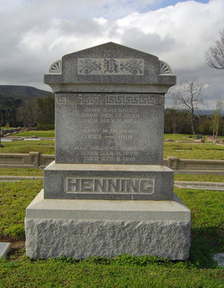
John S. Henning
| Birth | : | 17 Sep 1829 |
| Death | : | 7 May 1914 |
| Burial | : | Lompoc Evergreen Cemetery, Lompoc, Santa Barbara County, USA |
| Coordinate | : | 34.6296997, -120.4477997 |
| Description | : | Henning Will Filed A petition for the probate of the will of John Sanor Henning, who died at Lompoc. May 7, 1914, was filed with the superior court by Attorney A. G. Balaam of Lompoc. The estate is valued at $5OOO and consists of Lompoc property and stock in the Lompoc Oil Development company, the Santa Maria Planning Mill company, the Tally-Ho Oil company, the Lompoc Warehouse company, and Home Protection Association of Lompoc. The will was written entirely by the testator, September 3, 1912. He was 83 years old. All the estate is left to the widow. —Santa Barbara News. (Source:... Read More |
frequently asked questions (FAQ):
-
Where is John S. Henning's memorial?
John S. Henning's memorial is located at: Lompoc Evergreen Cemetery, Lompoc, Santa Barbara County, USA.
-
When did John S. Henning death?
John S. Henning death on 7 May 1914 in
-
Where are the coordinates of the John S. Henning's memorial?
Latitude: 34.6296997
Longitude: -120.4477997
Family Members:
Parent
Spouse

Siblings
Children
Flowers:


Nearby Cemetories:
1. Lompoc Evergreen Cemetery
Lompoc, Santa Barbara County, USA
Coordinate: 34.6296997, -120.4477997
2. Mission La Purisima Concepcion Cemetery
Lompoc, Santa Barbara County, USA
Coordinate: 34.6716652, -120.4216690
3. Saint Mary's Episcopal Memory Garden
Lompoc, Santa Barbara County, USA
Coordinate: 34.6807100, -120.4533500
4. Guillermo Eduardo de la Guerra Burial Site
Los Alamos, Santa Barbara County, USA
Coordinate: 34.7500000, -120.3500000
5. Los Alamos Cemetery
Los Alamos, Santa Barbara County, USA
Coordinate: 34.7327995, -120.2807999
6. Pine Grove Cemetery
Santa Barbara County, USA
Coordinate: 34.8550430, -120.4185950
7. Solvang Cemetery
Solvang, Santa Barbara County, USA
Coordinate: 34.6017000, -120.1443920
8. Mission Santa Ines Cemetery
Solvang, Santa Barbara County, USA
Coordinate: 34.5943880, -120.1365550
9. Saint Mark's-in-the-Valley Church Mem. Garden
Los Olivos, Santa Barbara County, USA
Coordinate: 34.6662590, -120.1177210
10. San Ramon Chapel Cemetery
Santa Barbara County, USA
Coordinate: 34.8478012, -120.2394028
11. Oak Hill Cemetery
Ballard, Santa Barbara County, USA
Coordinate: 34.6324997, -120.1106033
12. Santa Maria Cemetery District
Santa Maria, Santa Barbara County, USA
Coordinate: 34.9369011, -120.4253006
13. Dudley-Hoffman Memory Gardens Columbarium
Santa Maria, Santa Barbara County, USA
Coordinate: 34.9388480, -120.4215260
14. Bethel Lutheran Church Resurrection Garden
Santa Maria, Santa Barbara County, USA
Coordinate: 34.9415700, -120.4279900
15. Ontiveros Cemetery
Los Alamos, Santa Barbara County, USA
Coordinate: 34.8897000, -120.2334900
16. Our Lady of Guadalupe Catholic Cemetery
Guadalupe, Santa Barbara County, USA
Coordinate: 34.9284800, -120.5911300
17. Rancho del Cielo Cemetery
Santa Barbara, Santa Barbara County, USA
Coordinate: 34.5304780, -120.0758920
18. Guadalupe Cemetery
Guadalupe, Santa Barbara County, USA
Coordinate: 34.9582863, -120.5741501
19. Capuchin Cemetery
Santa Ynez, Santa Barbara County, USA
Coordinate: 34.6442860, -120.0270440
20. Saint Joseph of Cupertino Province Cemetery
San Luis Obispo County, USA
Coordinate: 35.0718803, -120.5263519
21. Saint John's Lutheran Church Columbarium
Arroyo Grande, San Luis Obispo County, USA
Coordinate: 35.1032070, -120.5808630
22. Halcyon Cemetery
Halcyon, San Luis Obispo County, USA
Coordinate: 35.1062000, -120.5994990
23. Saint Barnabas Memorial Garden
Arroyo Grande, San Luis Obispo County, USA
Coordinate: 35.1179910, -120.5706380
24. Arroyo Grande Cemetery
Arroyo Grande, San Luis Obispo County, USA
Coordinate: 35.1230011, -120.5930634