
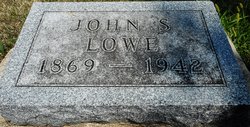

John Samuel Lowe
| Birth | : | 28 Jan 1869 New Market, Platte County, Missouri, USA |
| Death | : | 24 Mar 1942 Pawnee County, Nebraska, USA |
| Burial | : | Pawnee City Cemetery, Pawnee City, Pawnee County, USA |
| Coordinate | : | 40.1109009, -96.1608810 |
| Plot | : | Orig. 213- 1 |
| Description | : | Son of William A. & Sarah Dodson Lowe. Married to Florence E. Stratton June 1, 1898 in Pawnee County, Nebraska. (Pawnee Library, book of obits in Pawnee Republican.) (Pawnee Republican, Apr. 2, 1942.) JOHN S. LOWE John Samuel Lowe was born Jan. 28, 1869, at New Market, Mo. He was the third child born to Wm. A. and Sara A. Lowe. In 1885 the family moved to St. Joseph, Mo., where John worked in dry goods stores. Later he went to Beatrice to accept a position as a dry goods salesman. From Beatrice he came to Pawnee City in 1894 to work in the B. D.... Read More |
frequently asked questions (FAQ):
-
Where is John Samuel Lowe's memorial?
John Samuel Lowe's memorial is located at: Pawnee City Cemetery, Pawnee City, Pawnee County, USA.
-
When did John Samuel Lowe death?
John Samuel Lowe death on 24 Mar 1942 in Pawnee County, Nebraska, USA
-
Where are the coordinates of the John Samuel Lowe's memorial?
Latitude: 40.1109009
Longitude: -96.1608810
Family Members:
Parent
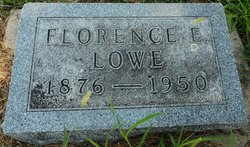
Spouse
Siblings
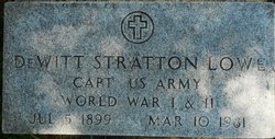
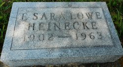
Children
Flowers:


Nearby Cemetories:
1. Pawnee City Cemetery
Pawnee City, Pawnee County, USA
Coordinate: 40.1109009, -96.1608810
2. East Amish Cemetery
Table Rock, Pawnee County, USA
Coordinate: 40.1310000, -96.0854000
3. Evergreen Cemetery
Pawnee County, USA
Coordinate: 40.0485992, -96.1417007
4. Pleasant Valley Cemetery
Pawnee County, USA
Coordinate: 40.0299988, -96.1554794
5. Table Rock Cemetery
Table Rock, Pawnee County, USA
Coordinate: 40.1791400, -96.1037400
6. Prairie Star Pioneer Cemetery
Du Bois, Pawnee County, USA
Coordinate: 40.0293000, -96.1041000
7. Beranek Cemetery
Table Rock, Pawnee County, USA
Coordinate: 40.2042007, -96.1607971
8. Pleasant Ridge Cemetery
Du Bois, Pawnee County, USA
Coordinate: 40.0156000, -96.1494000
9. West Branch Cemetery
Pawnee County, USA
Coordinate: 40.0787940, -96.2797160
10. Saint Anthonys Cemetery
Steinauer, Pawnee County, USA
Coordinate: 40.2075005, -96.2189026
11. Johnson Creek Cemetery
Pawnee City, Pawnee County, USA
Coordinate: 40.0270000, -96.2465000
12. Clear Creek Cemetery
Table Rock, Pawnee County, USA
Coordinate: 40.2193985, -96.1391983
13. Bohemian Cemetery
Table Rock, Pawnee County, USA
Coordinate: 40.1786003, -96.0374985
14. Saint Peters Evangelican Cemetery
Du Bois, Pawnee County, USA
Coordinate: 40.0010000, -96.1095000
15. Dry Branch Pioneer Cemetery
Richardson County, USA
Coordinate: 40.1292000, -96.0100021
16. DuBois Cemetery
Du Bois, Pawnee County, USA
Coordinate: 40.0231018, -96.0488968
17. Bohemian Cemetery
Richardson County, USA
Coordinate: 40.1175003, -95.9955978
18. Saint Johns Cemetery
Table Rock, Pawnee County, USA
Coordinate: 40.2148000, -96.0657000
19. Salems Cemetery
Steinauer, Pawnee County, USA
Coordinate: 40.2166000, -96.2555000
20. McCaffrey Cemetery
Nemaha County, USA
Coordinate: 39.9827100, -96.1474500
21. Madden Cemetery
Axtell, Marshall County, USA
Coordinate: 39.9866800, -96.2490300
22. Friedens United Church of Christ Cemetery
Bern, Nemaha County, USA
Coordinate: 39.9929008, -96.0529480
23. Saint Peters Lutheran Church Cemetery
Steinauer, Pawnee County, USA
Coordinate: 40.2555000, -96.1801000
24. Cincinnati Cemetery
Du Bois, Pawnee County, USA
Coordinate: 40.0042000, -96.0274963